


108 – GA8377 – HERTZ STUDIO SRL
Main authors: arch. Monica Crețu, arch. Sergiu-Dorian Leucă, arch. Alexandru-Ștefan Vasiliu, arch. Radu Constantin, arch. Adelina-Ștefania Popa
Colaboratori specialități: landscape arch. Sorin Ciorapciu, eng. Ovidiu Chițu
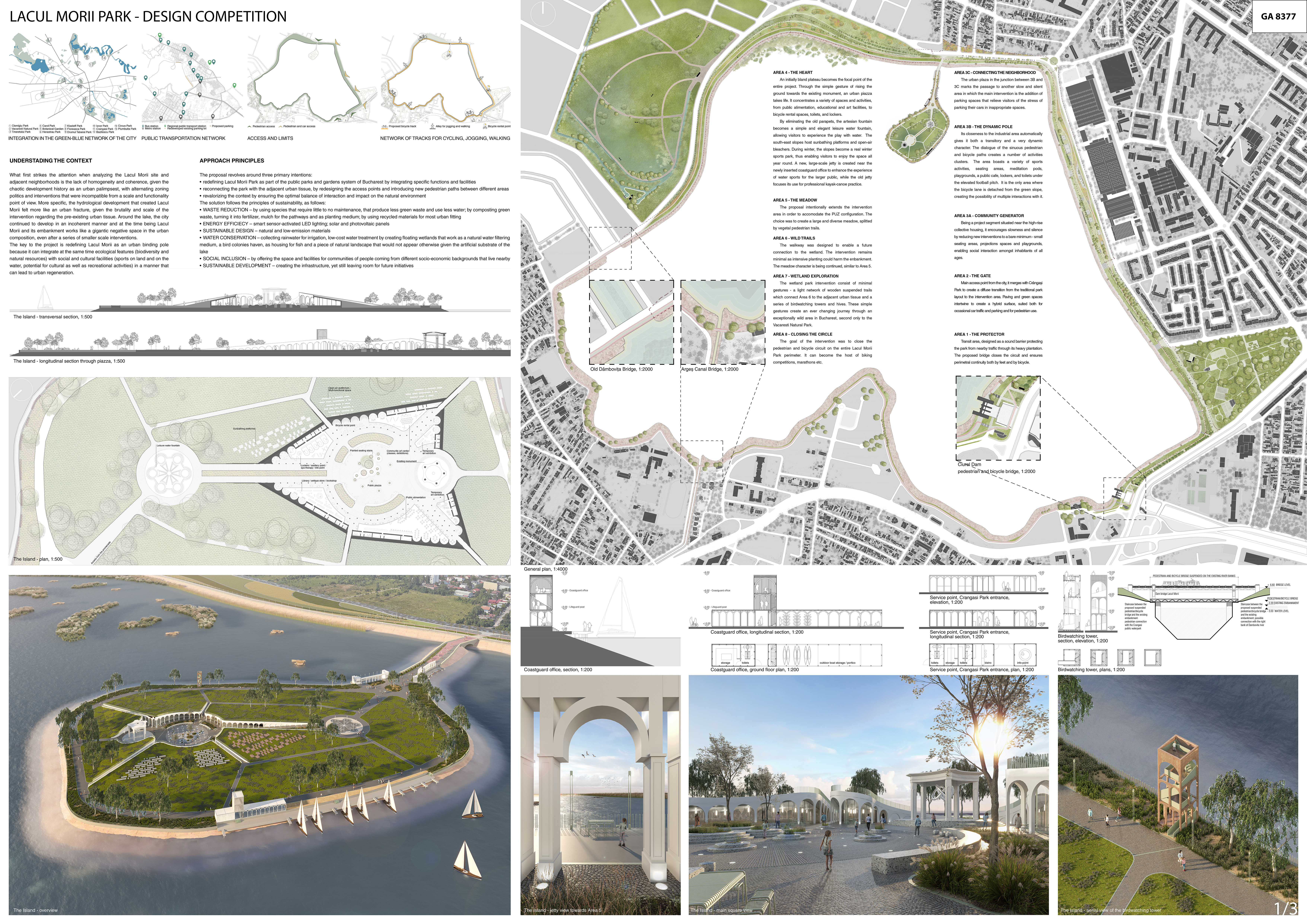
UNDERSTANDING THE CONTEXT
What first strikes the attention when analyzing the Lacul Morii site and adjacent neighborhoods is the lack of homogeneity and coherence, given the chaotic development history as an urban palimpsest, with alternating zoning politics and interventions that were incompatible from a scale and functionality point of view. More specific, the hydrological development that created Lacul Morii felt more like an urban fracture, given the brutality and scale of the intervention regarding the pre-existing urban tissue. Around the lake, the city continued to develop in an incoherent manner and at the time being Lacul Morii and its embankment works like a gigantic negative space in the urban composition, even after a series of smaller scale interventions.
The key to the project is redefining Lacul Morii as an urban binding pole because it can integrate at the same time ecological features (biodiversity and natural resources) with social and cultural facilities (sports on land and on the water, potential for cultural as well as recreational activities) in a manner that can lead to urban regeneration.
APPROACH PRINCIPLES
The proposal revolves around three primary intentions:
- redefining Lacul Morii Park as part of the public parks and gardens system of Bucharest by integrating specific functions and facilities
- reconnecting the park with the adjacent urban tissue, by redesigning the access points and introducing new pedestrian paths between different areas
- revalorizing the context by ensuring the optimal balance of interaction and impact on the natural environment
The solution follows the principles of sustainability, as follows:
- WASTE REDUCTION – by using species that require little to no maintenance, that produce less green waste and use less water; by composting green waste, turning it into fertilizer, mulch for the pathways and as planting medium; by using recycled materials for most urban fitting
- ENERGY EFFICIECY – smart sensor-activated LED lighting; solar and photovoltaic panels
- SUSTAINABLE DESIGN – natural and low-emission materials
- WATER CONSERVATION – collecting rainwater for irrigation, low-cost water treatment by creating floating wetlands that work as a natural water filtering medium, a bird colonies haven, as housing for fish and a piece of natural landscape that would not appear otherwise given the artificial substrate of the lake
- SOCIAL INCLUSION – by offering the space and facilities for communities of people coming from different socio-economic backgrounds that live nearby
- SUSTAINABLE DEVELOPMENT – creating the infrastructure, yet still leaving room for future initiatives
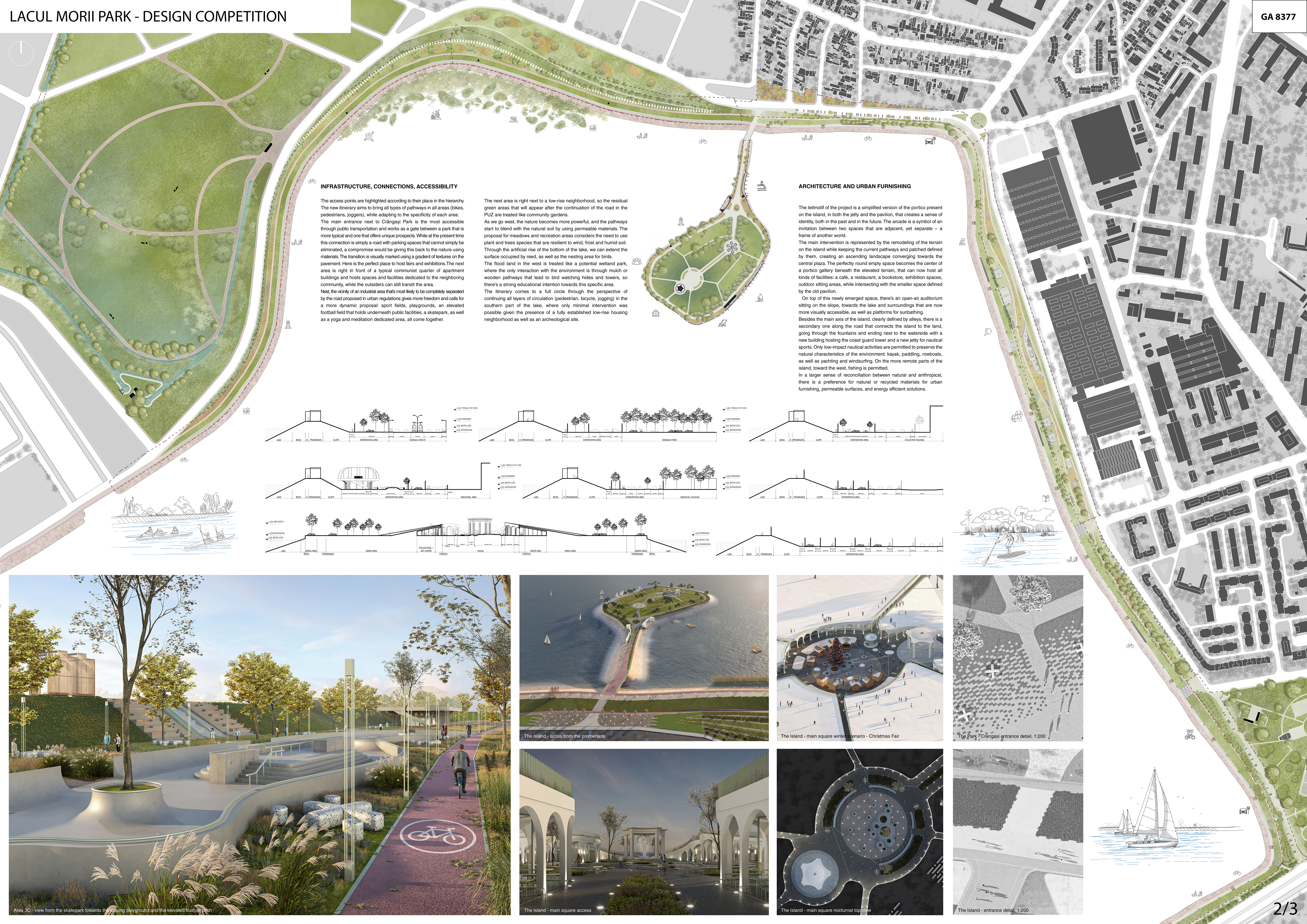
INFRASTRUCTURE, CONNECTIONS, ACCESSIBILITY
The access points are highlighted according to their place in the hierarchy.
The new itinerary aims to bring all types of pathways in all areas (bikes, pedestrians, joggers), while adapting to the specificity of each area:
The main entrance next to Crângași Park is the most accessible through public transportation and works as a gate between a park that is more typical and one that offers unique prospects. While at the present time this connection is simply a road with parking spaces that cannot simply be eliminated, a compromise would be giving this back to the nature using materials. The transition is visually marked using a gradient of textures on the pavement. Here is the perfect place to host fairs and exhibitions.
The next area is right in front of a typical communist quarter of apartment buildings and hosts spaces and facilities dedicated to the neighboring community, while the outsiders can still transit the area.
Next, the vicinity of an industrial area that’s most likely to be completely separated by the road proposed in urban regulations gives more freedom and calls for a more dynamic proposal: sport fields, playgrounds, an elevated football field that holds underneath public facilities, a skatepark, as well as a yoga and meditation dedicated area, all come together.
The next area is right next to a low-rise neighborhood, so the residual green areas that will appear after the continuation of the road in the PUZ are treated like community gardens.
As we go west, the nature becomes more powerful, and the pathways start to blend with the natural soil by using permeable materials. The proposal for meadows and recreation areas considers the need to use plant and trees species that are resilient to wind, frost and humid soil.
Through the artificial rise of the bottom of the lake, we can extend the surface occupied by reed, as well as the nesting area for birds.
The flood land in the west is treated like a potential wetland park, where the only interaction with the environment is through mulch or wooden pathways that lead to bird watching hides and towers, so there’s a strong educational intention towards this specific area.
The itinerary comes to a full circle through the perspective of continuing all layers of circulation (pedestrian, bicycle, jogging) in the southern part of the lake, where only minimal intervention was possible given the presence of a fully established low-rise housing neighborhood as well as an archeological site.
ARCHITECTURE AND URBAN FURNISHING
The leitmotif of the project is a simplified version of the portico present on the island, in both the jetty and the pavilion, that creates a sense of identity, both in the past and in the future. The arcade is a symbol of an invitation between two spaces that are adjacent, yet separate – a frame of another world.
The main intervention is represented by the remodeling of the terrain on the island while keeping the current pathways and patched defined by them, creating an ascending landscape converging towards the central plaza. The perfectly round empty space becomes the center of a portico gallery beneath the elevated terrain, that can now host all kinds of facilities: a café, a restaurant, a bookstore, exhibition spaces, outdoor sitting areas, while intersecting with the smaller space defined by the old pavilion.
On top of this newly emerged space, there’s an open-air auditorium sitting on the slope, towards the lake and surroundings that are now more visually accessible, as well as platforms for sunbathing.
Besides the main axis of the island, clearly defined by alleys, there is a secondary one along the road that connects the island to the land, going through the fountains and ending next to the waterside with a new building hosting the coast guard tower and a new jetty for nautical sports. Only low-impact nautical activities are permitted to preserve the natural characteristics of the environment: kayak, paddling, rowboats, as well as yachting and windsurfing. On the more remote parts of the island, toward the west, fishing is permitted.
In a larger sense of reconciliation between natural and anthropical, there is a preference for natural or recycled materials for urban furnishing, permeable surfaces, and energy efficient solutions.
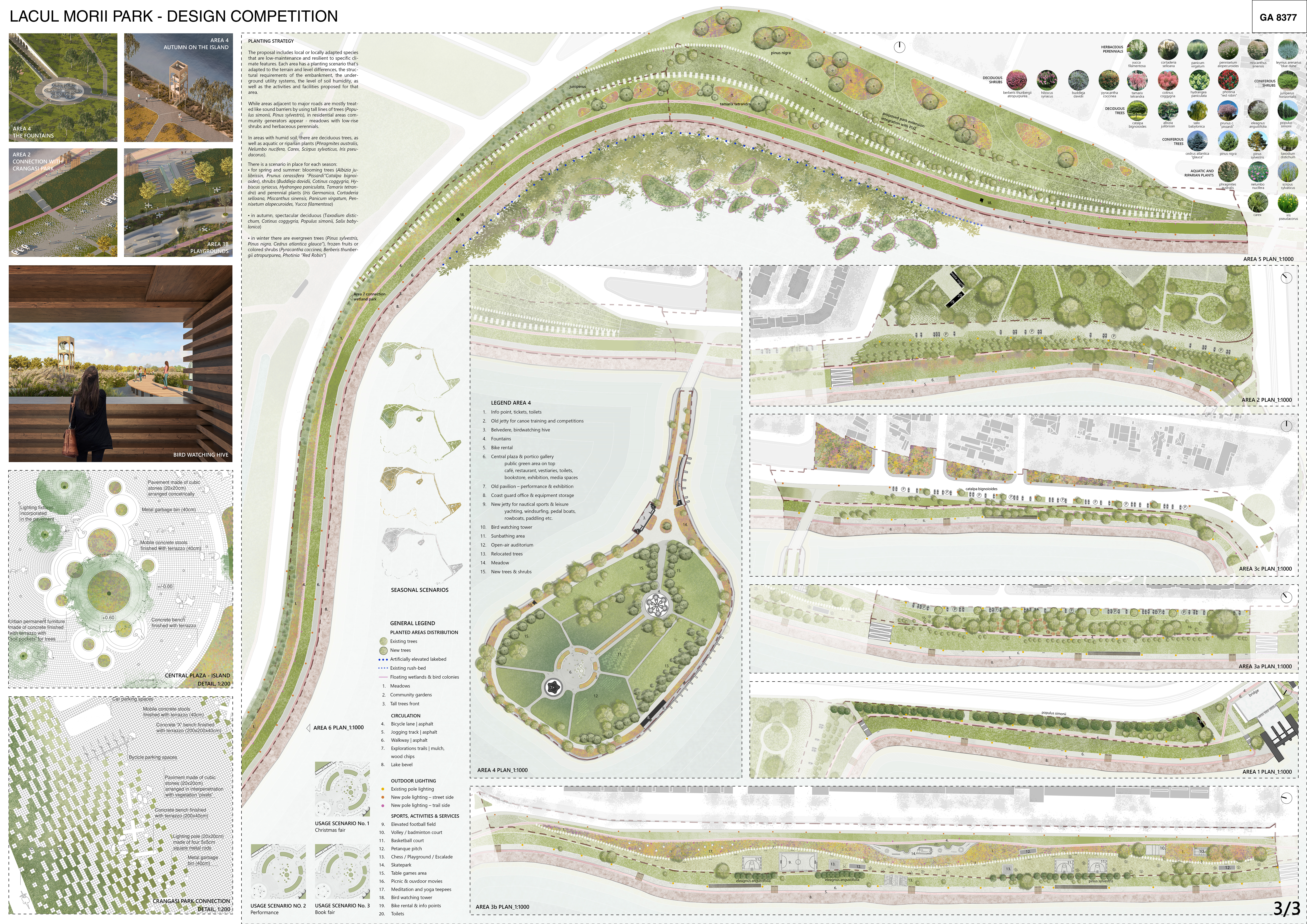
PLANTING STRATEGY
The proposal includes local or locally adapted species that are low-maintenance and resilient to specific climate features. Each area has a planting scenario that’s adapted to the terrain and level differences, the structural requirements of the embankment, the underground utility systems, the level of soil humidity, as well as the activities and facilities proposed for that area.
While areas adjacent to major roads are mostly treated like sound barriers by using tall lines of trees (Populus simonii, Pinus sylvestris), in residential areas community generators appear – meadows with low-rise shrubs and herbaceous perennials.
In areas with humid soil, there are deciduous trees, as well as aquatic or riparian plants (Phragmites australis, Nelumbo nucifera, Carex, Scirpus sylvaticus, Iris pseudacorus)
There is a scenario in place for each season:
- for spring and summer: blooming trees (Albizia julibrissin, Prunus cerassifera “Pissardi”Catalpa bignoioides), shrubs (Buddleja davidii, Cotinus coggygria, Hybiscus syriacus, Hydrangea paniculata, Tamarix tetrandra) and perennial plants (Iris Germanica, Cortaderia selloana, Miscanthus sinensis, Panicum virgatum, Pennisetum alopecuroides, Yucca filamentosa)
- in autumn, spectacular deciduous (Taxodium disticchum, Cotinus coggygria, Populus simonii, Salix babylonica)
- in winter there are evergreen trees (Pinus sylvestris, Pinus nigra, Cedrus atlantica glauca”), frozen fruits or colored shrubs (Pyracantha coccinea, Berberis thunbergii atropurpurea, Photinia “Red Robin”)
AREA 1 – THE PROTECTOR
Transit area, designed as a sound barrier protecting the park from nearby traffic through its heavy plantation.
The proposed bridge closes the circuit and ensures perimetral continuity both by feet and by bicycle.
AREA 2 – THE GATE
Main access point from the city, it merges with Crângași Park to create a diffuse transition from the traditional park layout to the intervention area. Paving and green spaces intertwine to create a hybrid surface, suited both for occasional car traffic and parking and for pedestrian use.
AREA 3A – COMMUNITY GENERATOR
Being a project segment situated near the high-rise collective housing, it encourages slowness and silence by reducing new interventions to a bare minimum – small seating areas, projections spaces and playgrounds, enabling social interaction amongst inhabitants of all ages.
AREA 3B – THE DYNAMIC POLE
Its closeness to the industrial area automatically gives it both a transitory and a very dynamic character. The dialogue of the sinuous pedestrian and bicycle paths creates a number of activities clusters.
The area boasts a variety of sports activities, seating areas, meditation pods, playgrounds, a public cafe, lockers, and toilets under the elevated football pitch.
It is the only area where the bicycle lane is detached from the green slope, creating the possibility of multiple interactions with it.
AREA 3C – CONNECTING THE NEIGHBORHOOD
The urban plaza in the junction between 3B and 3C marks the passage to another slow and silent area in which the main intervention is the addition of parking spaces that relieve visitors of the stress of parking their cars in inappropriate spaces.
AREA 4 – THE HEART
An initially bland plateau becomes the focal point of the entire project. Through the simple gesture of rising the ground towards the existing monument, an urban piazza takes life. It concentrates a variety of spaces and activities, from public alimentation, educational and art facilities, to bicycle rental spaces, toilets, and lockers.
By eliminating the old parapets, the artesian fountain becomes a simple and elegant leisure water fountain, allowing visitors to experience the play with water.
The south-east slopes host sunbathing platforms and open-air bleachers. During winter, the slopes become a real winter sports park, thus enabling visitors to enjoy the space all year round.
A new, large-scale jetty is created near the newly inserted coastguard office to enhance the experience of water sports for the larger public, while the old jetty focuses its use for professional kayak-canoe practice.
AREA 5 – THE MEADOW
The proposal intentionally extends the intervention area in order to accommodate the PUZ configuration. The choice was to create a large and diverse meadow, split by vegetal pedestrian trails.
AREA 6 – WILD TRAILS
The walkway was designed to enable a future connection to the wetland. The intervention remains minimal as intensive planting could harm the embankment. The meadow character is being continued, similar to Area 5.
AREA 7 – WETLAND EXPLORATION
The wetland park intervention consists of minimal gestures – a light network of wooden suspended trails which connect Area 6 to the adjacent urban tissue and a series of birdwatching towers and hives. These simple gestures create an ever-changing journey through an exceptionally wild area in Bucharest, second only to the Văcărești Natural Park.
AREA 8 – CLOSING THE CIRCLE
The goal of the intervention was to close the pedestrian and bicycle circuit on the entire Lacul Morii Park perimeter. It can become the host of biking competitions, marathons etc.