


100 – RB1994 – PRÁCTICA Arquitectura y Urbanismo SLP – STUDIO DE PEISAJ ANA HORHAT SRL
Main authors: arch. Jaime Daroca, arch. José Mayoral, arch. José Ramón Sierra, arch. peis. Horhat Ana-Maria
Architectural collaborators: peis. Georgiana NISTOR, arch. Teodora PASCU, peis. Felicia RADOVICIU, arch. Ivona SVINȚI-NECHITA, arch. Costan SVINȚI, arch. peis. Raul Brito, arch. peis. María Ignacia Jerez, arch. Joaquin Troncoso, arch. Miguel Bergera
Specialty collaborators: Bogdan Simmionescu (Rendering)
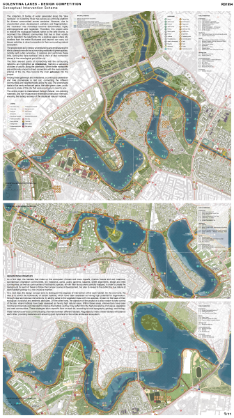
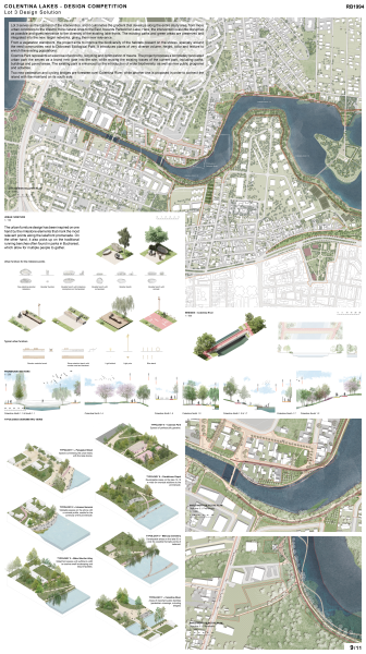
CONCEPTUAL INTERVENTION SCHEME
The collection of bodies of water generated along the “lake necklace” on Colentina River has serves as a thriving platform for diverse communities across centuries. However, due to uncontrolled urban development, pollution and fragmentation, the “necklace” has nowadays become disconnected, highly anthropogenized and neglected. Therefore, this project aims to restore the ecological habitats native to the lake shores, to reconnect the different communities that live in their vicinity and to transform the lakefronts into a positive space where city dwellers from the entire Bucharest and beyond can carry out leisure activities in direct connection to their surrounding natural ecosystem.
The project does so by deeply understanding and emphasizing the site’s connections with the surrounding networks of green spaces, mobility and public amenities. It restores and reinforces these links, turning the “lake necklace” into a chain of vital connection pieces in the neurological grid of the city.
The most relevant points of connectivity with the surrounding networks are highlighted as milestones, marking a sequence of nodes of activity along the lakefronts. When these milestones are additionally placed in direct connection with the main mobility arteries of the city, they become the main gateways into the project.
Among these gateways and milestones, a continuous pedestrian and bike promenade is laid out, connecting the different communities and neighborhoods along the way. The promenade leads to five newly enhanced parks, that offer green, open, public spaces to areas of the city that were previously in need to one.
The entire project is materialized through natural, non-polluting materials, and non-invasive and reversible construction methods, ensuring the lasting recovery of the displaced natural habitats.
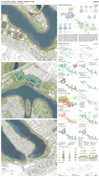
Vegetation strategy
As a first step, the habitats that make up this ecosystem (forests and trees massifs, riparian forests and wet meadows, spontaneous vegetation communities, dry meadows, parks, public gardens, squares, street alignments, sedge and reed communities, as well as communities of hydrophilic species, all with their fauna) were carefully mapped, in order to create the background for each of these to follow their proper course of development, but also to reveal to the public the true nature of each habitat typology in a non-invasive manner.
As a next step, the design concept aims to distinguish the degrees of intervention within each habitat. On the one hand, the idea is to enrich the biodiversity of certain habitats, which have been assessed as having high potential for regeneration, through clear and precise interventions, by adding value to the vegetation base with new species, chosen on the basis of their ecological, functional and aesthetic attributes. On the other hand, the objective of the project is to allow nature to take control of the site, where habitats have been assessed as having high natural value. Within these areas, interventions have been minimal and discrete and intended to improve the habitat, as they may suffer from the high prevalence of invasive vegetation and reed communities. These strategies take a specific form on each lot, according to local topography, geology, and biology.
Water networks serve as communicating channels between different habitats. Regulated by water, these habitats will balance each other, providing resilience and ensuring good dynamics for the whole landscape ecosystem.
Gateways and milestones
The project breaks down and rationalizes the entire promenade along the fronts of the lakefronts in order to make it more accessible for all the inhabitants of the city. Gateways are projected in those points where the promenade meets the main mobility arteries. Between gateways, as series of milestones mark the way as in ancient Roman roads, while also offering points of activity (loaded with urban furniture, pavilions and rooms for outdoor activities) in those spaces that are already significant to the different neighborhoods around the lakes. They become a new network for sustainable mobility, ecological regeneration and leisure.
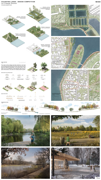
Urban furniture
The urban furniture design has been inspired on one hand by the milestone elements that mark the most relevant points along the lakefront promenade. On the other hand, it also picks up on the traditional running benches often found in parks in Bucharest, which allow for multiple people to gather.
Pavilions
Different pavilions are projected on the various milestone locations along the entire site. On one hand, typical small pavilions ranging from 16 to 50 sqm and housing programs like restrooms, kiosks, cafés or exhibition rooms are scattered along the entire lakefront promenade. On the other hand, site-specific pavilions are designed for each of the five secondary objective in the three lots, housing the programs that each of these specific sites currently lack.
These pavilions are designed as temporary and reversible constructions made out of natural and recyclable materials, while also offering a strong and durable configuration. Natural boulders serve as support elements as well as above-ground foundations, and they link back to the concept of the milestone that marks the most relevant points along the way. The construction is covered by a modular, wooden, grid canopy and enclosed with glass panels over metal framework. The assemble and disassembly process is quick, efficient and cheap.
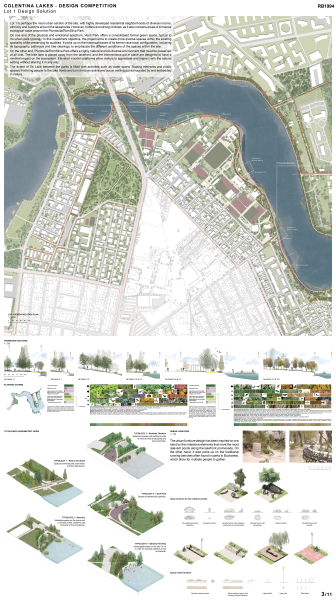
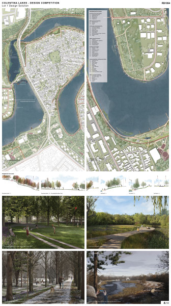
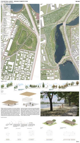
LOT 1 – 2nd MENTION
Lot 1 is perhaps the most urban section of the site, with highly developed residential neighborhoods of diverse income, ethnicity and customs around the lakeshores. However, it offers and strong contrast, as it also contains areas of immense ecological value around the Plumbuita/RomSilva Park.
On one end of the physical and emotional spectrum, Verdi Park offers a consolidated formal green space, typical to its urban park typology. In this investment objective, the project aims to create more diverse spaces within the existing spatiality while preserving its qualities. It picks up on the historical traces of its former race track configuration, including its topography, pathways and tree clearings, to emphasize the different conditions of the spaces within the site.
On the other end, Plumbuita/RomSilva Park offers a highly natural and bio-diverse environment that must be preserved at all cost. The bike lane is placed away from the lakefront, and the interventions put in place are designed to have a minimal impact on the ecosystem. Elevated wooden platforms allow visitors to appreciate and interact with the natural setting without altering it in any way.
The extent of Tei Lake between the parks is filled with activities such as water sports, floating elements and public spaces that bring people to the lake fronts and turn it into an active and social melting pot surrounded by and embedded in nature.
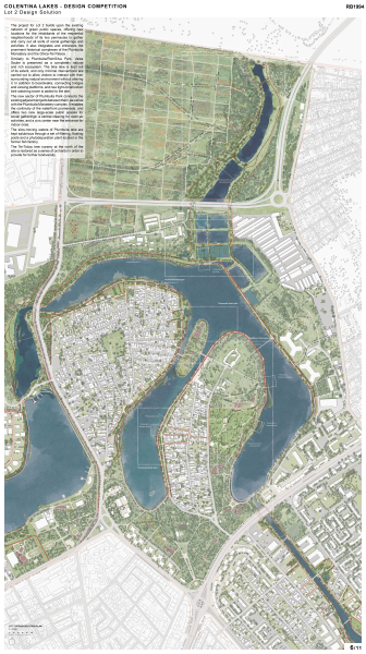
LOT 2 – 2nd MENTION
The project for Lot 2 builds upon the existing network of green public spaces, offering new locations for the inhabitants of the residential neighborhoods of its two peninsulas to gather and carry out all sorts of social gatherings and activities. It also integrates and enhances the prominent historical complexes of the Plumbuita Monastery and the Ghica-Tei Palace.
Similarly to Plumbuita/RomSilva Park, Valea Saulei is preserved as a completely natural and rich ecosystem. The bike lake is kept out of its extent, and only minimal interventions are carried out to allow visitors to interact with their surrounding natural environment without altering it. In addition to boardwalks, connecting bridges and viewing platforms, and new light-construction bird-watching tower is added to the site.
The new sector of Plumbuita Park connects the existing adjacent projects between them, as well as with the Plumbuita Monastery complex. It enables the continuity of the waterfront promenade, and offers two new large-scale public spaces for social gatherings: a central clearing for open-air activities, and a civic center near the entrance for indoor ones.
The slow-moving waters of Plumbuita lake are kept salubrious through a set of filtering, floating pools and a phytodepuration plant located in the former fish factory.
The Tei-Toboc tree nursery at the north of the site is restored as a series of orchards in order to provide for further biodiversity.
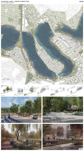
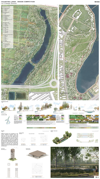
LOT 3 – 1st MENTION
Lot 3 serves as the East end of the intervention, and it culminates the gradient that develops along the entire study area, from more urban conditions to the West to more natural ones to the East, towards Pantelimon Lake. Here, the intervention is as little disruptive as possible and gives relevance to the diversity of the existing lake fronts. The existing paths and green areas are preserved and integrated into the new, larger networks, giving them new relevance.
From a vegetation standpoint, the project aims to improve the biodiversity of the habitats present on the shores, especially around the reed communities next to Dobroești Ecological Park. It introduces plants of very diverse volume, height, color and texture to enrich the existing populations.
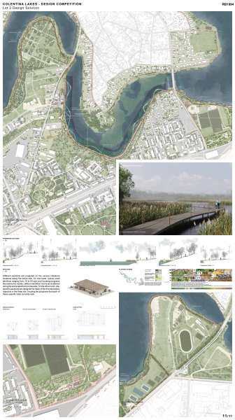
Cosmos Park represents an exercise of economy, recycling and optimization of means. The project proposes a completely renovated urban park the serves as a brand-new gate into the site, while reusing the existing traces of the current park, including paths, buildings and paved areas. The existing park is enhanced by the introduction of wider biodiversity, as well as new public programs and activities.
Two new pedestrian and cycling bridges are foreseen over Colentina River, while another one is proposed in order to connect the island with the mainland on its south side.