


101 – CC2024 – PUNCT BIROU DE ARHITECTURĂ SRL
Main authors: Andrei Bacoșcă, Mădălina Doroftei, Ruxandra Grigoraș, Lázár Csaba, Mădălina Perju, Daniel Șerban

LOT 3 – 2nd MENTION
Conceptual Intervention Framework
The Colentina Lakes are not merely a green-blue spine within a large city but rather a visceral display of hydrology, metropolitan areas and landscape. The development of such an extensive and complex system requires not only a vision but also a clear effort in investigation and restoration. The outcome is a series of urban and landscape acupuncture interventions at various scales, where the dosing and correlation with the hinterland – the area beyond the intervention limit – can hardly be too sensitive or specific, in this phase. On one hand, there are very different places along the shores, with varying degrees of accessibility and exposure, and numerous blockages; on the other, there seem to be many similar situations where similar proposals seem self-evident yet are difficult to replicate. Undoubtedly, the question will arise as to whether a unified approach is possible or even opportune, which in the end may present more of a challenge than a necessity.
Ultimately, the response to the basic requirement of making the entire intervention area accessible and interconnected can itself generate a certain expressiveness through the complexity of technical solutions implemented for resolving access, transit and relationships between different levels, adapted to the particularities of each location. The seriality of these principle solutions, their specific technical implementations and the use of similar morphologies for developed elements – whether architectural or landscaping, can project a possibility and a concept for implementation.
Even so, a project of such magnitude and scope can almost never be fully completed, not only due to the long and sometimes difficult phasing but also to the immense dynamism of the adjacent urban and metropolitan area.
In outlining a strategy at the scale of the whole, the presented proposal relies on several intervention principles, succinctly described below:
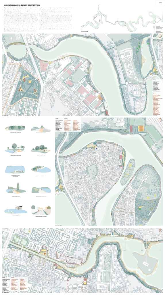
- Continuity of the mobility corridor through pedestrian and bicycle-dedicated surfaces. Creating convenient connections for both pedestrians and cyclists between the different successive subzones of the intervention corridor.
- Varying and separating the pedestrian and bicycle paths in areas with steep transverse slopes or in certain locations where the pedestrian path can be favoured by opening valuable perspectives, accompanied by rest areas, sometimes in the proximity of the water surface.
- Separating the pedestrian path from the bicycle path in sections where there are local streets parallel to the shore, which, through restructuring, receive traffic-calming measures and allow bicycle transit (e.g., Tei-Toboc Peninsula, part of the Plumbuita Peninsula).
- Prioritizing pedestrian traffic at circulation nodes.
- Configuring adjacent streets in a shared space regime with minimal prospect and one-way car traffic, wherever possible.
- Introducing, where the street prospect allows, tree rows interspersed with longitudinal parking spaces.
- Delineating planted strips between property boundaries and the street, in the case of very narrow streets and entrances (a solution similar to Varna Street).
- Varying the route and its position in relation to the shores by locally diverting portions of the perimeter pathways / roads, thus creating space for public areas or developments in the immediate vicinity of the water (e.g., Tei-Toboc Peninsula, the Colentina Canal area).
- Using similar configurations of a significant portion of the alleys and other elements used in the development, with recognizable morphologies that reinforce the continuity of the public space across its different sectors.
- Capitalizing on valuable perspectives from areas with large water surfaces that highlight the morphology of the lake system.
- Introducing different scales in the development of the intervention corridor subzones, such as ample lawns in the main parks: Verdi, Plumbuita, Tei, the student sports base, or consolidating previously excessively fragmented areas (e.g., in Tei-Toboc Peninsula, Cosmos Park). Even though each case explores specific spatial characteristics – whether it is the placement on a ridge with a wide perspective towards the water (in Tei Park), the proximity to the shore in an area previously arranged for swimming (student sports base), or a central plateau immersed in the middle of the park (Plumbuita) – it always imparts a different character to the lawn. Verdi Park, with its clear, compact delineation, distinct and non-tangent to the lake system, receives a distinct identity. In its case, the composition relies on a more fluid line morphology, a composition that contrasts with the existing double row of trees of the median alley.
- Repurposing and refurbishing existing circulations and facilities/functional areas (e.g., elements from the student sports base). Traces of previous developments, from the lakes’ more glorious eras, exist in various states of preservation, often requiring “urban archaeology” operations.
- Soft developments in areas with a pronounced natural character (e.g., Petricani Swamp, Saulei Valley, Dobroești Park area).
- Using modular structures for various functions of the public space network: rain shelters, bird observatories, boat storage, commercial or food service points, toilets, etc., which also serve as landmarks along the routes.
- Pavilions, pontoons and lake walkways use a mix of engineered wood and metal for structure and drilled metal piles for the base. Impermeabilized solid and engineered wood is specified for walking and contact surfaces.
- New mineral areas employ mostly permeable surfaces of stabilized aggregates.
- Paths and stairs are made of concrete and asphalt, and can be therefore easily maintained and repaired.
- Vegetation strategy:
- Using native tree species, arranged in regular formations, marks the intervention and introduces accents at key points along the route (e.g., rows of Populus Nigra Italica marking important crossing points, etc.).
- Irregularly placing trees to complement existing clusters, where it is considered necessary to consolidate vegetation masses. Additionally, removing certain tree and shrub specimens from poorly maintained areas with excessive spontaneous vegetation growth.
- Planting shrubs to accentuate the proximity of paths or access points, as well as for the screening of backyards adjacent to the intervention area.
- Introducing ground cover/perennial plant surfaces to mark important routes and configurations within the development.
- A reduced percentage of mowed grass surfaces – mainly in designated areas within lawns or adjacent to certain circulation zones, with the rest being designated as un-mowed meadow areas.
- Utilizing water plants to highlight and conserve existing elements: former enclosures/swimming pools demarcated in the lake basins, presently out of use.
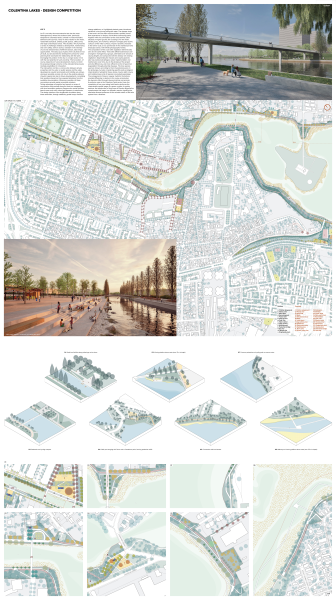
About lot 3
Lot 3 is not only the most extensive but also the most heterogeneous, where the southern bank, previously tangential to urbanized areas, unfolds in broad meanders between built-up areas, rarely in direct relation to the water, residential backyards, existing public spaces, utility zones, and large undeveloped areas. This situation, which presents a series of challenges related to development, maintenance, and even safety, with an obvious variation in the intensity of use and attractiveness of different sectors, also brings opportunities. The status quo of parts of the city that are not yet built, but are planned for development, allows for urban planning that maximizes the relationship with the bank, leveraging this position in the city on a larger scale, in line with the real potential of such proximity. Their evolution, of course, depends on future development visions, to which the proposed design scheme on the allocated strips leaves multiple possibilities for interaction.
The intervention corridor, a narrow strip between private properties and the water or public spaces and the water, developed as a public promenade and mobility axis, allows, whenever possible, access not only to the existing network of public spaces but also to future developments, correlating their positions based on the proposed situations from the available documentation. Whenever possible, all these connections provide easily accessible solutions.
Taking advantage of irregular land parcels, a series of construction-free pockets along the bank are equipped with local amenities, in relative accordance with sectoral demographics: gardens, playgrounds, sports facilities, beach areas, and even urban-type squares or waterfronts. The design solution of the lengthwise circulation along these amenities, through setbacks, gentle loops, direction change platforms, or highlighted planted areas, introduces variations in the journey along the water. The steeper slope of the land in this lot often requires distinct profiles, tiered flow separations on slopes, and inclined connecting paths. Together with the connections to the areas behind, often situated on higher ground, the crossings over the water, existing locks, and numerous direction changes given by the contours of the water surfaces, impart a dynamic character to the entire route, a true promenade in the architectural and landscape sense, with infinite photographic frames.
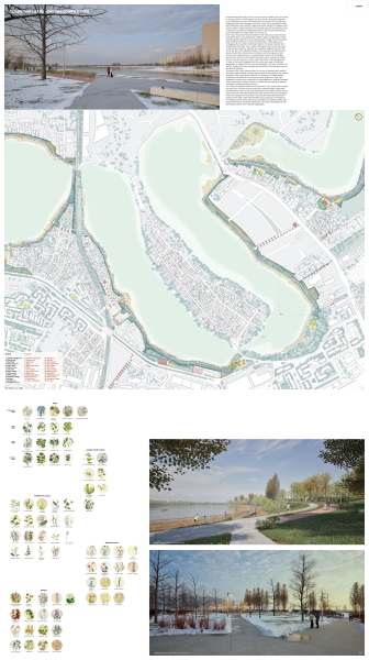
The composition of this route with vegetation elements also aims for the same effect. Trees with different demeanours are arranged in homogeneous groups, alternated over sectors of varying lengths and composed with the already rich existing vegetation. Segmenting the masses and varying species also has practical advantages: easier implementation and maintenance over time, due to the phasing of the project and site differences, and more efficient control of specimen degradation through potential diseases. The tree species used are chosen according to their character/presence in the landscape, but also considering specific pedo-ecological characteristics: hydrophilic trees, dense crowns, light crowns, and notable trees (a list of species is provided separately).
The arrangement of trees in regular, rhythmic formations, oriented differently in relation to the route, accentuates the dynamic effect through diverse rhythms and accents. A particular case is the Colentina Canal sector. Here, the completion of tree rows along both banks reinforces the characteristic spatial image of a green corridor. In certain sections, the introduction of long rows of Populus Nigra Italica complements this image in a dramatic manner, signalling the otherwise discreet presence of this valuable sector of the lake system from a distance.
Complementing the trees, the use of shrubs serves to flank areas near paths or access points, to furnish slopes, and to screen the backyards adjacent to the intervention corridor. The introduction of surfaces with ground cover vegetation/perennials highlights important routes and configurations within the development and protects certain directional changes. In addition to the reeds present in large areas, the use of aquatic plants is proposed as a way to enhance and preserve existing elements: former enclosures/swimming pools delineated in the lake basins, now out of use.
In the case of Cosmos Park, the expansion with new areas to the east and towards the lake is accompanied by a clearer spatial reorganization: while maintaining the positions of some existing paths, a large central, elongated area is defined, oriented in an east-west direction, containing a group of playgrounds. Its position and shape allow for the visual hierarchy and amplification of the park and a clearer emphasis on the main access point on the western boundary, towards the residential neighbourhood, and the exit to the lake in the opposite direction. The new layout of directions and access points offers more natural connections with the adjacent street structure and organizes flows in a subordinate manner, from the edges towards the central area and further towards the lake, through the added areas on the east side. As in other cases, the surface of the playgrounds is made of sand and integrated into the central area made of stabilized aggregates, as opposed to the concrete alleyways. For further contrast, but also for shading, this area is planted with multi-stem, thornless specimens of Gleditsia Triacanthos.
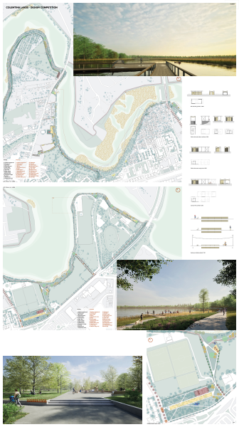
Throughout Lot 3, light constructions, in the form of pavilions with modular structures made of metal and engineered wood, are provided for the various amenities of the public space network: rain shelters, bird observatories, boathouses, commercial or food service points, toilets, etc. Their light, middle-tech architecture is specified for implementation in different contexts without becoming a foreign presence, but also has the capacity to become orientation landmarks along the routes.
The choice of materials follows three main criteria. The construction of alleys and stairs from concrete and of bicycle lanes from asphalt, besides reasonable implementation costs, aims at easy maintenance and simpler repairs. On the other hand, soft, reversible interventions with reduced visual and ecological impact are employed in areas with a pronounced natural character and in relation to the water: gravel paths, solid and laminated wood for walking surfaces and contact areas, pontoons and waterway paths with metal infrastructure and drilled metal piles, and mineral embankments with permeable surfaces from stabilized aggregates.