


121 – AJ1001 – JB ARHITECTURA, ADN BIROU DE ARHITECTURĂ, BEROS ABDUL ARHITECȚI ASOCIAȚI
Autori principali: JBA – Johannes Andreas Bertleff, Dana Cucoreanu; ADNBA – Andrei Șerbescu, Eduard Untaru, Roberta Frumușelu, Adrian Untaru; BAA – Christian Beros
Co-autor: Alexandru Belenyi, Diana Valentina Bogdan, Liviu Creoșteanu, Raluca Grecea, Andrei Mitrea
Colaboratori arhitectură: Amina Alchihabi, Sebastian Balaci, Mara Bejan, Ruxandra Chiriță, Simina Cîrneanu, Iris Comănescu, Ilinca Mărăcine, Andrada Neagu, Sorin Olteanu, Andreas Samanis, Rebecca Tomoială, Ionuț Ursachi, Adrian Bratu (Visualizations), Andrei Răzvan (Visualizations), Antonia Gherasim
Colaboratori specialități: Horia Preduș (Sistematizare Verticală)
“Proiectul identifică în mod convingător calitățile existente ale patrimoniului industrial, rămășițele intervențiilor trecute, urmele construite și sistemele naturale, cum ar fi vegetația și râul Timiș, ca elemente esențiale pentru o nouă viziune asupra Platformei Rulmentul din Brașov.
Conceptul se concentrează pe reabilitarea sitului, caracterizat drept un peisaj industrial neierarhic, prin reutilizarea elementelor existente și reactivarea unor zone mai mari, cum ar fi cartierele rezidențiale recente, pentru a forma un țesut urban centrat în jurul unui nou parc public, conectându-l la orașul Brașov.
Juriul susține perspectiva proiectului conform căreia este necesară dezvoltarea unei strategii la nivelul întregului oraș pentru a consolida legăturile, în special în ceea ce privește infrastructura și furnizarea de noi facilități (de exemplu, școli și grădinițe). Propunerea sugerează adăugarea a două noi inele de legătură în sud (Zaharia Stancu și Henri Coandă) prin sensuri giratorii și extinderea conexiunilor către nordul comunei Sânpetru. Acest concept este eficient deoarece pune accent pe trasee prietenoase pentru pietoni și bicicliști, menținând coeziunea sitului fără întreruperi majore datorate infrastructurii rutiere.
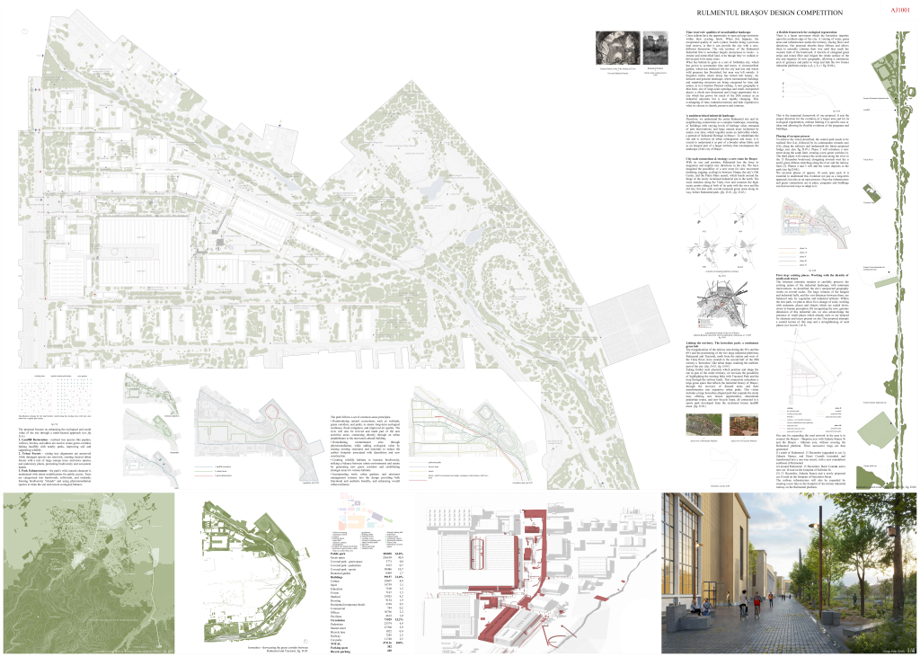
Proiectul oferă o viziune urbană care permite regenerarea socială și ecologică fără a limita utilizarea sau dezvoltările viitoare. Faza propusă, împărțită în patru etape de câte 10 ani fiecare, este convingătoare, începând cu noua structură de parc public. Echilibrul între spațiul destinat parcului și suprafețele construite respectă cerințele proiectului, cu următoarea împărțire:
- 63% parc public (aproximativ 50% parc, 10% sporturi în sala acoperită C25, 1,5% parc interior în sala C25)
- 21% suprafețe construite
- 15,2% infrastructură (5% trasee pietonale, 6% spații comune, 0,4% piste pentru biciclete, 2,5% parcări, 1,5% căi ferate)
Viziunea oferă o schimbare convingătoare de scară, bazată pe consolidarea a ceea ce există deja, oferind noi momente în locuri autentice, descoperite și cartografiate în verdele și solul existent între hangare și hale industriale. Acest nou parc public central este realizat prin intervenție și gestionare minime. Dezvoltarea sistemului natural și a vegetației din jurul râului Timiș în nord este un element de legătură și de îmbogățire a parcului, în special între cele două dealuri ale depozitului de deșeuri.
Apreciem această soluție pentru autenticitatea sa.
Per ansamblu, este un concept profund analizat, bine dezvoltat și vizionar, care are potențialul de a crea un sit unic pentru locuitorii Brașovului și, eventual, ca investiție comună cu Sânpetru. Acest proiect poate fi un catalizator pentru regenerarea nordului Brașovului, precum și un incubator pentru o nouă dezvoltare urbană, economică, socială și culturală pentru întreaga regiune. Juriul recomandă realizarea cu celeritate a acestui proiect unic. Acest proces ar trebui să fie însoțit de un consiliu interdisciplinar format din mai mulți experți și discipline diferite pentru a asigura implementarea cu succes pe termen lung a conceptului .
Propunerea poate fi un prototip pentru gestionarea fostelor situri industriale din România și un exemplu inovator în Europa.
Time reservoir: qualities of an unfamiliar landscape
Cities seldom have the opportunity to open up large territories within their existing limits. When this happens, the exceptional quality of such a place, besides being a precious land reserve, is that it can provide the city with a new, different dimension. The vast territory of the Rulmentul Industrial Site is nowadays largely anonymous to locals – a remote and untravelled land, even though they’ve walked or driven past it for many years.
What lies behind its gates is a sort of forbidden city, which has grown to accumulate time and traces. A circumscribed garden, which has sheltered life the city had lost and where wild greenery has flourished, but man was left outside. A forgotten realm, where decay has turned into beauty. An intricate and genuine landscape, where monumental buildings and surprising structures are being conquered by time and nature, as in a timeless Piranesi etching. A new geography is thus born, one of large-scale openings and small, unexpected places: a whole new dimension and a huge opportunity for a city which has grown for much of the 20th century as an industrial epicentre but is now rapidly changing. This overlapping of time, industrial memory and lush vegetation is what we choose to cherish, preserve and continue.
A non-hierarchical industrial landscape
Therefore, we understand the entire Rulmentul site and its neighbouring connections as a complex landscape, consisting of buildings with varying levels of heritage value, remnants of past interventions, and large unused areas reclaimed by nature over time, which together create an indivisible whole: a portrait of Industrial Heritage in Brasov. To rehabilitate the site and to envision its urban reintegration and reuse, it is crucial to understand it as part of a broader urban fabric and as an integral part of a larger territory that encompasses the landscape of the city of Brașov.
City-scale connections & strategy: a new route for Brașov
With its size and position, Rulmentul has the force to magnetize and imprint new directions in the city. We have imagined the possibility of a new route for slow movement (trekking, jogging, cycling) in between Tâmpa, the city’s Old Center, and the Piatra Mare massif, which bends around the hinge of the newly reclaimed industrial site in the north. The route stretches along the Timiș river and connects the high, scenic points sitting at both of its ends with the river and the old city, but also with several (unused) green areas along its way, before Rulmentul park.
Linking the territory. The horseshoe park: a continuous green belt
The reorganization of the railway area during the 50’s and the 60’s and the positioning of the two large industrial platforms, Rulmentul and Tractorul, north from the station and west of the Timiș River, have created in the second half of the 20th century a ‘horseshoe’-like urban shape, marking the northern part of the city.
Taking further such elements which position and shape the site as part of the wider territory, we envision the possibility of highlighting the existing links with Tractorul Park and the loop through the railway lands. This connection articulates a large green space that reflects the industrial history of Brașov, through the recovery of disused areas and their transformation into expansive urban parks. This vision includes a large horseshoe-shaped park that expands the study area, offering educational pedestrian routes, and new bicycle loops, all connected to a sports park developed from the reclaimed former landfill areas.
A flexible framework for ecological regeneration
There is a latent movement which the horseshoe imprints upon the northern edge of the city. A veining of water, green areas and infrastructure marks the territory, tracing flows and directions. Our proposal absorbs these ribbons and allows them to naturally continue their way until they reach the western limit of the boulevard. A fascicle of elongated green strips and routes filter and irrigate the whole surface of the site and organize its new geography, allowing a continuous arch of greenery and parks to wrap and link the two former industrial platforms.
This is the important framework of our proposal. It sets the proper direction for the evolution of a larger area and for its ecological regeneration, without limiting it to specific uses or ideas and allowing for flexible evolution of the programs and buildings.
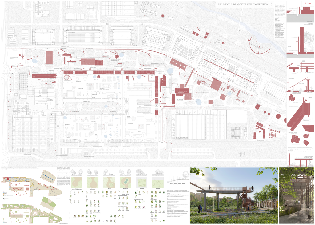
Phasing of an open process
To achieve the vision described, the central park needs to be realized first (1a), followed by its continuation towards east (1b), along the railways and underneath the future proposed bridge. Phase 2 will introduce a new street along the south limit, creating a new green corridor (ε). The third phase will connect the north area along the river to the 13 December boulevard, elongating towards west the α and β green ribbons stretching along the river and the railway lines (3).Phases 4 and 5 will add the waste deposits to the park.
We envision phases of approx. 10 years span each. It is essential to understand this evolution not just as a long-term approach, but also as an open process. Once the infrastructure and green connections are in place, programs and buildings can find several ways to adapt to it.
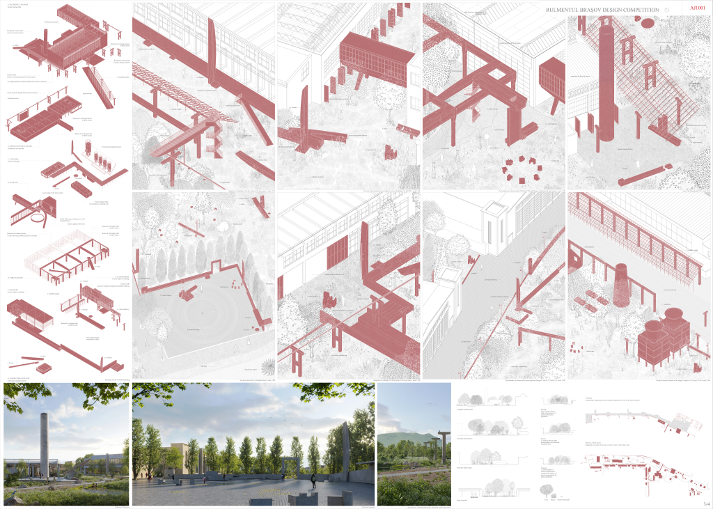
First step: existing places. Working with the identity of small-scale traces
The foremost intention remains to carefully preserve the existing nature of the industrial landscape, with minimum interventions. As described, the site’s unexpected geography works on several scales. The huge volumes of the hangars and industrial halls, and the vast distances between them, are balanced only by vegetation and industrial artifacts. Within the new park, we plan to allow for a change of scale, working with moments, places and objects which are scaled down, closer to human perception. By recognizing the new, genuine dimension of this industrial site, we also acknowledge the presence of small places which already exist or are induced by elements and traces present on site. Our proposal attempts a careful lecture of this map and a strengthening of such places.