


116 – CF8842 – CUMULUS ARCHITECTURE SRL – ATELIER FOAIE VERDE SRL
Main authors: arch. Soare Adrian
Co-authors: arch. Busuioc Flavius, peisagist Triboi Nicolas
Architectural collaborators: arch. Ionescu Ancuța, arch. Badarau Iulian, std. arh. Vrabie Cristina, std. arch. Misosniky Luca, arch. Neag Bianca Maria, std. arch. Statescu Maria, std. arch. Bigiu Stefania, std. arch. Stanescu Andrei
Collaborator 3D Render: arch. Cumpanasoiu Andrei, arch. Horia Ene, arch. Cosmin Pantelimon
Architecture consultant: arch. Eliza Yokina, arch. Teodor Frolu
Landscaping collaborators: SC ATELIER FOAIE VERDE SRL, peis. Arina Boariu, peis. Yanis Pelletier, arch. Codruta Pop
Speciality collaborators: eng. Ionica Razvan, arch. Remi Lelievre; Environmental conservation specialist: Barbulescu Dan; Administrative specialist: Cristina Dedu
LOT 1 – 3rd PRIZE
“ This project proposed nature-based solutions with rain water collection in Verdi Park. The jury appreciated that this project emphasised the connection between the surrounding neighbourhoods and the study areas through the water management strategy. The jury also noted that this team put forward a long term 50-year strategy for restoration of the landscape and was one of the few teams that proposed a planting strategy. The jury felt that the scheme for the pavilions and architectural elements could have been more developed and questioned the position of the bridges.” – appreciation of the Jury

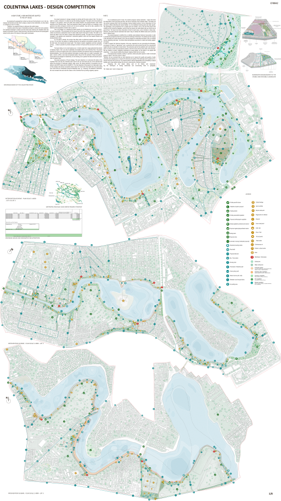
A NEW FUTURE, A NEW WATERSCAPE ADAPTED TO THE CITY SCALE
By analyzing the geographical context we discover that Bucharest is not a flat city. Actually, the flat does not exist, there is always a slope of a few centimeters, of a few meters or sometimes of even 10 meters.
Therefore, our proposal follows to rediscover the subtle slopes.
Colentina Lakes show signs of remarkable ecological, cultural and scenic potential. The Colentina landscape is drawn by all the small scars made by the rainwater which has flowed for thousands of years in these territories. We observe and discover the hydrographic network which gives all its beauty to these gentle landscapes.
PART 1
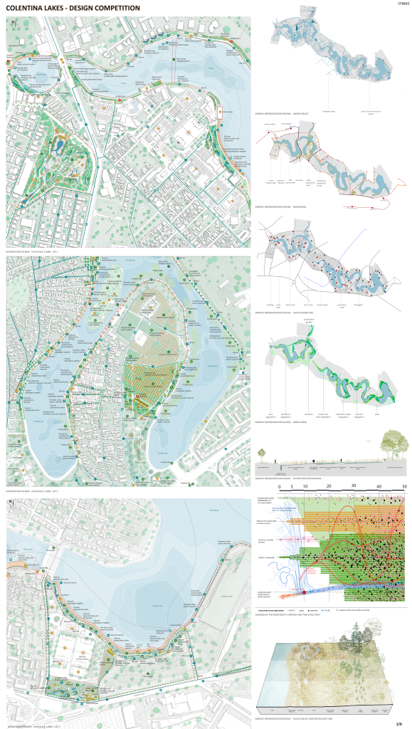
Our project proposes to manage rainwater by starting with the place where it falls. The drop of water is a value, a resource, it is what can save the existing ecosystem. The water will be recovered and managed in rain-gardens, which will gently flow towards filtration and phytopurification areas before returning to the Colentina Lakes. These new objectives linked to water will allow us to redesign a more generous city where ecological corridors will not only be aesthetic, they will be vital, essential to the balance of the ecosystems of which man is a part of.
Thus, the strategy is to manange the natural spaces by not interfering too much and ‘’recycle’’ as much as possible. The promenade and the bicycle lane which they represent the tool through which visitors can discover a perspective closer to nature rotate around small pools of water. This water is collected and taken to the river where it always been attracted by gravity. The water will be recovered and managed in rain-gardens and sometimes in productive gardens, which will flow towards filtration and phytopurification areas.
So, the water is thereby, the solution that offers both an arhitectural aesthetic and an ecological one. On one hand, the pleasure of walking among the rain-gardens surrounded by aquatic flora, on the other hand, the recycled and reused water. This network of green (vegetation) and blue (rainwater, springs…) makes it possible to provide ecological corridors for fauna and flora but also for soft circulations.
The Saulei Valley is not a small watercourse, it collects water from a large watershed that extends to Baneasa Airport. This is an area of potentially recoverable water for the Colentina River.
The project proposes to recover the watercourses and to preserve protection and treatment areas by decantation and phytoremediation.
One of the best protection techniques to protect water is to make it accessible. Kayakers, canoers, SUPers, seek clean and pleasant waters, they will be the sentinels of these ecosystems. Some areas will be refuges for biodiversity, for bird nesting, but in general the lakes will become accessible for aquatic hikes.
Our project proposes a 50-year strategy. The main objective is to restructure the banks of the Colentina River and also the Colentina itself, and for this we must think and act on the elements that define the processes of landscape creation: water cycles, the natural potential of ecosystems and our ability to work WITH nature and not AGAINST it. The main objective of the project is to make water clean, to find complex and diverse ecosystems where nature will invite itself, like hawks that cross the planet from South Africa to Scandinavia using the Walachian road, by “choosing” the wetlands of Wallachia. We must recreate links and invite this nature on the Colentina River by finding migratory species.
PART 2
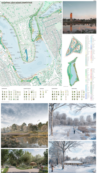
As an architectural point of view, the solution proposes vertical landmarks – towers that allow the observation of the local fauna and flora, but also an overview of the Colentina Lakes. The towers are like vertical sculptures that fit into the landscape, having multiple functions, from an observatory for flora and fauna, without disturbing the natural habitat, to a non-traditional learning place and study spaces. The advantages of the perspective from a height point are multiple, such as the fact that ground level visibility can be limited by vegetation, and the view from above can reveal details that you could miss at ground level. The towers also allow observation of hard-to-reach areas, such as treetops or steep areas. Moreover, the towers become landmarks that make it easy to identify the different areas and to perceive them in different ways.
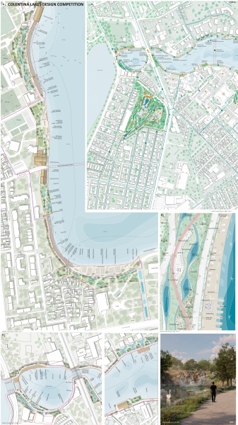
Our project proposes to redefine the co-visibility zones between historical monuments in order to recreate the perspectives that have structured the landscape of Bucharest. The wetland and the mystery of the reed beds are a basic element, this is why we propose to renaturalize the banks of the co-visibility zone by replanting reed areas. To reinforce these atmospheres we propose to create new floating vegetated islands.
In order to support the historical character of the area, especially the one surrounding the Monastery, we propose to create an “agricultural” park, a productive and social orchard that will be an educational support but also an activator of social bonds. This productive park will be aesthetic and it will become a place of cultural, artistic and educational activities. Here the human will be at the center of the activities. We can imagine a nursery, integration workshops for young people, for the elderly or for people with disabilities… a new physical relationship between religious belief and civil society.
The proposal also includes a variety of pavilions, kiosks and public spaces in order to stimulate people to spend more time closer to nature.
Therefore, we can conclude that our main objectives are to improve the quality and quantity of water (rainwater and underground), to improve the diversity and quality of the landscape and to protect and rediscover the blue lines in the city. Our proposal seeks to reduce fragmentation and vulnerability of natural habitats and to take wildlife biology into account, preserving the existing ecosystem.
Designing the city means taking care of its history and implementing the techniques of finding testimonies and reconnecting them to geography.
The “tabula rasa” must no longer exist.
LOT 2 – 8th place
COLENTINA LIFESCAPE
A NEW FUTURE, A NEW WATERSCAPE ADAPTED TO THE CITY SCALE. Colentina needs a new and functional waterscape, because water is life. If we want to create recreational facilities we need to save the ecosistem, we need to improve the water management not only near lakes, but in all the city.
« If he tells me all he knows
Riverman, Nick Drake
‘Bout the way his river flows
And all night shows
In summertime »
By analyzing the geographical context we discover that Bucharest is not a flat city. The flat does not exist, there is always a slope, of a few centimeters, of a few meters sometimes of 10 meters.
NO DRAMATIC MOUNTAINS HERE, ONLY SUBTLE SLOPES TO REDISCOVER.
Colentina river and lakes are today already shows signs of remarkable ecological, cultural and scenic potential. Its vast scale, beautiful winding creeks and extensive wetlands.
The Colentina landscape is drawn by all the small scars made by the rainwater which has flowed for thousands of years in these territories. We observe and discover the hydrographic network which gives all its beauty to these gentle landscapes.
Our project proposes to manage rainwater by starting with the place where it falls. The drop of water is a value, a resource, it is what can save the river. We cannot continue to “throw” it into dirty waters, we must collect it, and gently take it towards the river where it has always been attracted by gravity.
The water will be recovered and managed in rain-gardens, which will gently flow towards filtration and phytopurification areas before returning to the Colentina River. These new objectives linked to water will allow us to redesign a more generous city where ecological corridors will not only be aesthetic, they will be vital, essential to the balance of the ecosystems of which man is a part!
Using the green and blue frames to organize the territory makes it possible to preserve, to find a great cohérence. This network of green (vegetation) and blue (rainwater, springs…) makes it possible to provide ecological corridors for fauna and flora but also for soft circulations, pedestrains and vicycles.
Mains objectives are :
- To save the Colentina river,
- To improve the quality of water,
- To improve the quantity of water ( rainwater and underground water)
- To improve the quality and diversity of the landscape, reconnecting with the urban waterscape
- To reduce fragmentation and the vulnerability of natural habitats and species habitats, and take their movements into account in the context of climate change
- To implement the water quality abs quantity objectives set by the river basin managment plan
- To take wildlife biology into account
- To facilite the genetic exchanges necessary to the survival of wildlife species
- To protect and redicover the blue lines in the city ; urban or natural talweg
The transformation of Colentina river based on rainwater managment and natural solutions should be a model of continued public engagement
The scale and unusual nature of this project have the potential to generate a great deal of interest and enthusiasm at public meetings. We needs, desires and dreams.
We propose a lot of scenic passive uses, ecological restoration and habitat creation. But in the same time we encurage educationnal activities, waterfront recreation, new opportunities for large scale recreational activities, commercial activities…
Colentina lifescape is both a place ans a process.
Lifescape is an ecological process of environmental reclamation and renewal on a vast scale, recovering not only the health and biodiversity of ecosystems across the site, but also the spirit and imagination of people who will use the new park. Lifescape is about the dynamic cultivation of new ecologies – —ecologies of soil, air and water; of vegetation and wildlife; of program and human activity; of financing, stewardship and adaptive management; of environmental technology, renewable energy and education; and of new forms of interaction among people, nature, technology and the passage of time.
FIND THE HISTORICAL LANDSCAPE
The Ghica-Tei and Plumbuita neighborhoods represent one of the historical gateways to the city of Bucharest. We must imagine the city protected by wetlands and mysterious forests.
On a 10m high promontory the Ghica family built a conac with the main entrance facing south, with a garden/forest planted with lime trees ( Tilia sp.) (Gradina Tei), and to the north, a romantic and mysterious belvedere over the marshes of the Colentina river, with in the middle of this “landscape painting”, the monastery of Plumbuita. This relationship with nature exists in several historical sites in the region (Mogosoaia, Buftea…)
Even today, people come to drink and bottle fresh, pure water from a historic spring at the foot of the Conac Ghica. It is difficult to imagine the historical landscape of these monuments, yet it is there in some details, the reeds, the slopes, the trees, the bell towers of the monastery and the palace church….
The Ghica family donated the entire palace and park to the city for good use, and today it seems appropriate to recover the strength, beauty and usefulness of these historical landscapes because they had a strong biodiversity, an undeniable beauty.
Our project proposes to redefine the co-visibility zones between historical monuments in order to recreate the perspectives that have structured the landscape of Bucharest. The wetland and the mystery of the reed beds are a basic element, this is why we propose to renaturalize the banks of the co-visibility zone by replanting reed areas. To reinforce these atmospheres we propose to create new floating vegetated islands
Designing the city means taking care of its history and implementing the techniques of finding testimonies and reconnecting them to geography.
The “tabula rasa” must no longer exist.
PRODUCTIVE AND SOCIAL LANDSCAPE
The monastery was built on an island in the middle of a wild and mysterious nature, but obviously the surrounding landscape was also composed of a productive landscape with orchards, meadows, vegetable areas. In order to support the historical character of the park, we propose to create an “agricultural” park, a productive and social orchard that will be an educational support but also an activator of social bonds.
This productive park will be aesthetic and it will become a place of cultural, artistic activities… a place different from other parks. Here the human will be at the center of the activities. We can imagine a nursery, integration workshops for young people, for the elderly or for people with disabilities… a new physical relationship between religious belief and civil society.
KNOW, LOVE, PROTECT AND TREAT WATER
The Saulei Valley is not a small watercourse, it collects water from a large watershed that extends to Baneasa Airport. This is an area of 1500ha, or 3 600 000 mc of potentially recoverable water for the Colentina River. The project proposes to recover the watercourses and to preserve protection and treatment areas by decantation and phytoremediation.
One of the best protection techniques to protect water is to make it accessible. Kayakers, canoers, SUPers, seek clean and pleasant waters, they will be the sentinels of these ecosystems. Some areas will be refuges for biodiversity, for bird nesting, but in general the lakes will become accessible for aquatic hikes.
THE SWIMMING POINT AND THE MIGRATION LINE
Our project proposes a 50-year strategy. The main objective is to restructure the banks of the Colentina River, but the Colentina itself, and for this we must think and act on the elements that define the processes of landscape creation: water cycles, the natural potential of ecosystems and our ability to work WITH nature and not AGAINST it. The main objective of the project is to make water clean, to find complex and diverse ecosystems where nature will invite itself, like the SOIMI that crosses the planet from South Africa to Scandinavia using the Walachian road, by “choosing” the wetlands of Wallachia… The natural area of Vacaresti is a remarkable biotope where we find more than half of the birds observable in the UNESCO Danube Delta biosphere reserve. We must recreate links and invite this nature on the Colentina River by finding migratory species.
WATCHTOWERS : A NETWORK OF OBSERVATION AND LEARNING POINTS
Our proposal offers a discovery of the city’s water. An aesthetic but also scientific discovery like the towers which could become real sentinels of the environment. Landscape observation towers, meeting places, learning places but also places for monitoring the quality of water and air, a sort of thermometer, barometer on the evolution of the health of our territory.
Like the Genoese towers monitored the shores of the seas, our towers will monitor and create the new landscape of the Colentina River.