


124 – OO9539 – ATELIER MENOU SRL
Main authors: dr. arch. Miruna Moldovan, arch. Alexandru Andrei Haraga, peis. Alexandra Mara Buz, stud. arch. Daria Odette Burdea-Balazs, stud. arch. Daria Sanda Mălan, stud. arch. Leonid Secher, stud. arch. Mădălin Constantin Stanciu, arch. Daciana Briana Vancea
LOT 1 – MENTION
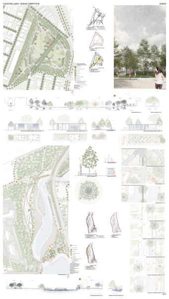
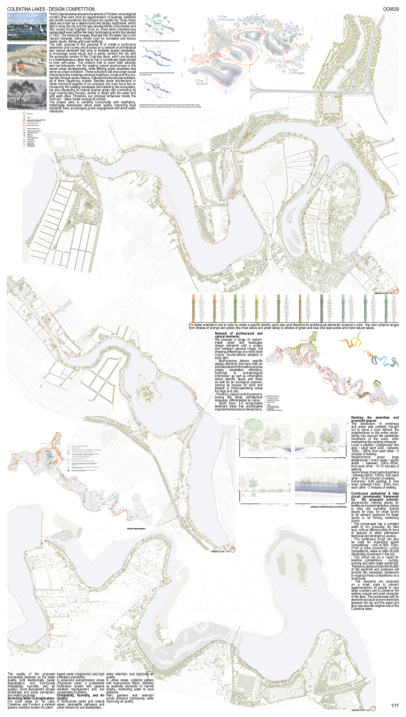
The 6 Colentina lakes are part of a network of 15 lakes: an ecological corridor (that were once an agglomeration of swamps, wetlands and prolific ecosystems) that crosses the capital city. Today these lakes are known as a destructured and sloppy membrane, which fails to bring the city and the new developments of Bucharest and Ilfov county closer together. Even so, these lakes’ potential was appreciated even before the major landscaping works that started in 1933. The historical images illustrate that the lakes had a rich natural character, being mostly used for recreation and leisure (water sports, fishing and even bathing).
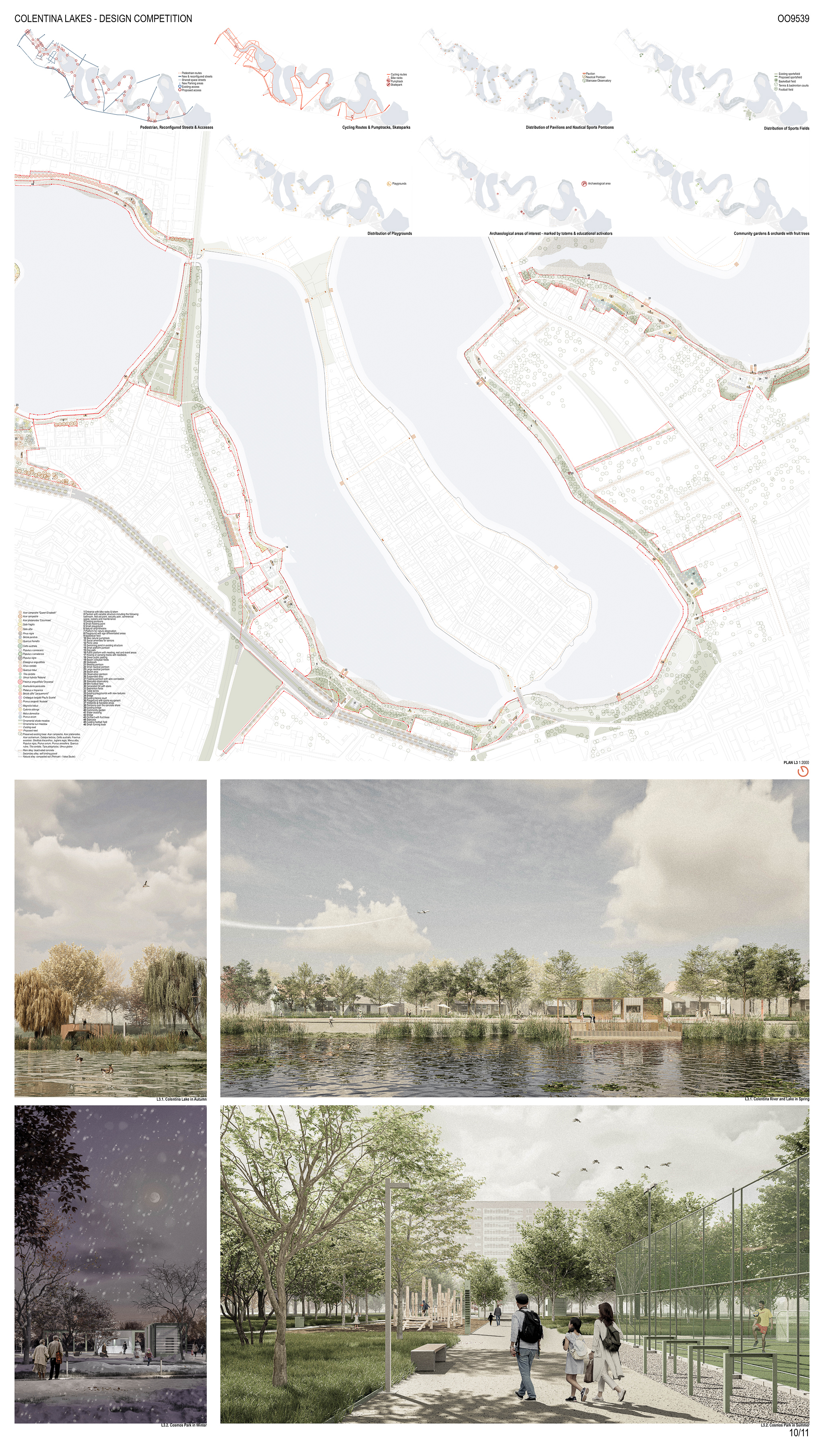
The main purpose of this proposal is to create a continuous pedestrian and cycling circuit based on a network of architectural and natural elements that aims to facilitate spatial orientation, to encourage social equity and to easily connect the city with the ecological corridor of the Colentina lakes, which are located in a heterogeneous urban tissue that is sometimes destructured or even peri-urban. This network tries to insert itself naturally and non-intrusively into the existing natural environment or the recent urban developments, while offering public amenities that serve as urban activators.
These activators will encourage social interactions like meetings amongst neighbors, locals and why not, tourists, through sports, leisure, cultural and educational activities, all of them happening outside. Besides these architectural or rather functional aspects of our proposal, the main focus lies on conserving the existing landscape and restoring the ecosystem, but also expanding its natural riparian areas and connecting its local communities (human, animal or floral) with the water and with each other. Therefore, our proposal enhances mostly the Petricani – Valea Saulei ecological corridor.
The project aims to combine functionality with aesthetics, challenging stereotypes about water quality, improving local residents’ lives, encouraging public engagement and direct water interaction.
Network of architectural and natural elements:
We propose a range of custom-made urban and landscape design elements with a unitary and coherent general image, but showing differences at a micro level (colors, functionalities) adapted to each lake:
- Multi-purpose totems: specific design elements that have both an educational and informative purpose (maps, orientation directions, historical & archaeological information as well as information about specific fauna and flora) as well as an ecological purpose, serving as houses for birds and insects or thirst-quenching areas for dogs and cats.
- Pavilions, playgrounds & pontoons: having the same architectural language, differentiated by color.
- Totem trees: 3-5 recognizable landmark trees that accentuates important entrances or intersections.
Ranking the amenities and proposed spaces:
The distribution of entrances and areas was carefully thought out to serve a local interest, the neighborhood or the entire sector, taking into account the pedestrian movement of the users, while maintaining the existing character.
Local: a pavilion / playground/ rest area / small sport area – between 150m. – 300m. from each other – 5 minutes of walking
Neighborhood areas: large playgrounds / event areas / sports areas – between 300m.-500m. from each other – 10-15 minutes of walking
Sector areas: major parks & gardens – between 600m.-1000m. from each other – 15-20 minutes of walking
Entrances: both existing & new ones – between 150m. – 300m. from each other – 5 minutes of walking
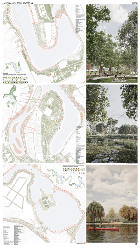
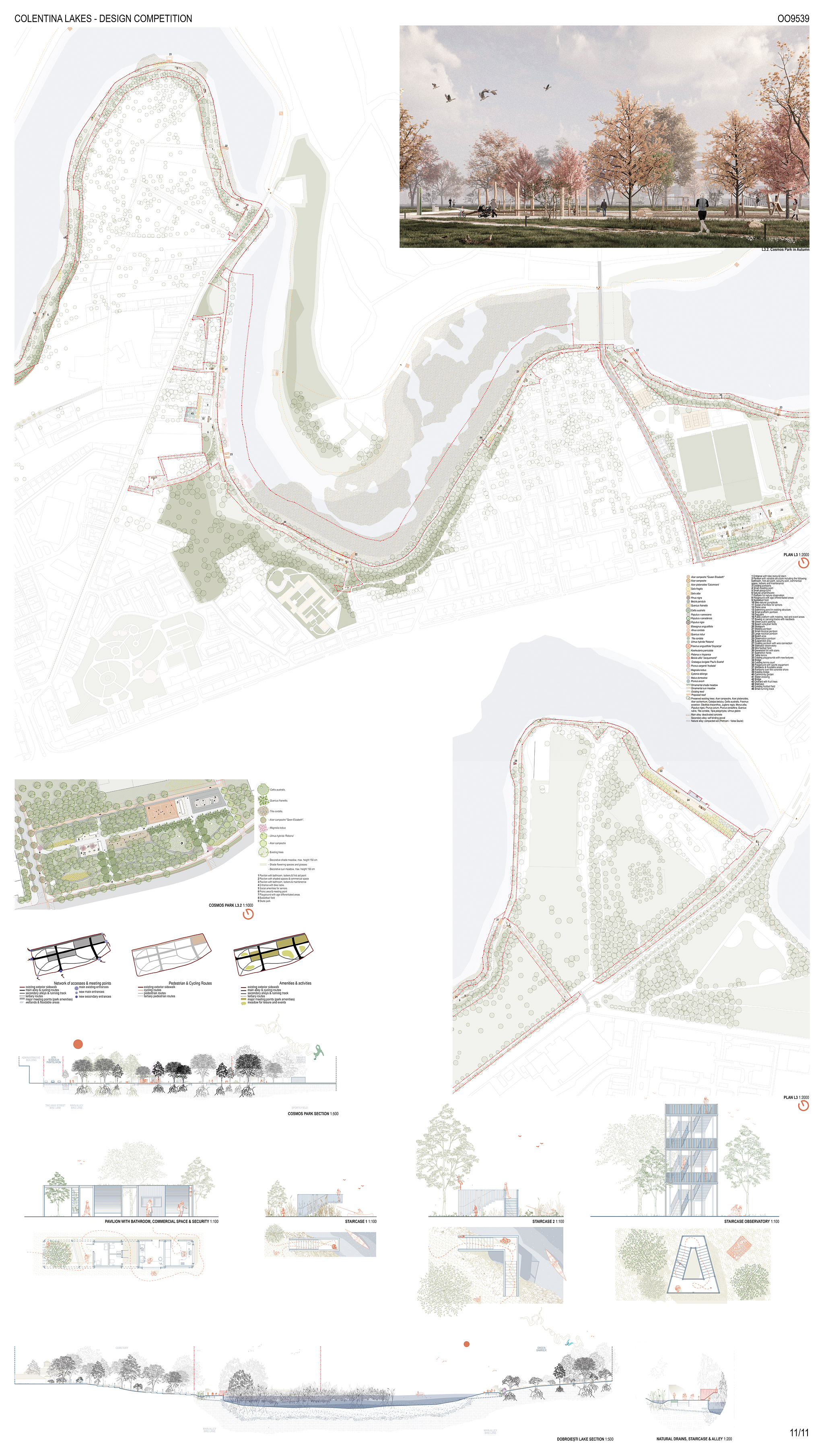
Continuous pedestrian & bike circuit (promenade) framework for the proposed network: playgrounds, meeting places for breaks and social interaction, places to relax and sunbathe, special places for dogs, for urban sports or for seniors, pontoons for water sports or for fishing, swimming ponds.
- The promenade has a constant width of 4m (including the bike lane, without differentiating the level or texture) to allow permanent technical and emergency access.
- This continuous circuit can also be used for organizing sports competitions – runs of 5km, 10km, 21km or 42km (marathon), cycling competitions, skate or roller circuits stimulating movement in the city.
- This circuit can be a basis for triathlon competitions – cycling, running and open-water swimming. The layout, design and fair distribution of the pavilions and pontoons will provide the necessary framework to organize these competitions on a local scale.
- The elements are proposed on a small scale to prevent agglomerations of people in very large numbers and to preserve the existing natural and quiet character of the area. The promenade with its elements act as an active membrane between the city and the water and thus resumes the original role of the Colentina lakes.
The quality of the proposed promenade depends on the water quality, both aesthetically (water degradation) and functionally (floodability, humidity, and air quality). Given Bucharest’s climate challenges and public perception, the project proposes:
Reversing Water Eutrophication:
For small areas on Tei Lake, Colentina, and Fundeni: a minimal passive reedbed system for plant-based water oxygenation and light infiltration prevention.
In advanced eutrophication zones (Plumbuita Lake): a sustainable biofiltration system with passive reedbed management and two oxygenating fountains.
Floodability, Humidity, and Air Quality:
In flood-prone parks and natural areas: permeable pathways and urban forests for soil stabilization, water retention, and improved air quality.
In urban areas: collector gutters with hydrocarbon filters, doubling as aesthetic elements on narrow streets, redirecting water to local wetlands.
Rain gardens and retention ponds enhance biodiversity while improving air quality.
Restoring an ecosystem:
In the case of an ecosystem, this means restoring both its quantity and its quality, especially as regards its physical state, its chemical state, its species composition, its structure, and its ability to function as a complex interconnected habitat taking into account external influences. The restoration process begins as soon as the restoration measures have been put in place, but this does not immediately result in the ecosystems reaching a good condition. It could take some time before the ecosystem reaches that stage.
This is because different habitats recover at different rates. Experience has shown that a river or floodplain, for instance, might take a few years to reach its full ecological potential. A natural forest, raised bog or dry grassland, on the other hand, could take several decades or more to regain the full complex mix of plant and animal species that characterize it.
Restored sites should also be protected from degrading again to ensure they reach and are maintained in a good condition. The EU Biodiversity Strategy commits EU Member States to protect 30% of the EU territory for nature by 2030, of which 10% should be strictly protected. Restoration should therefore work hand in hand with this protection target to maximize the benefits.
Typical restoration measures:
- Forests: Diversify the age structure and tree species composition; protect large, old and senescent trees; progressively convert monocultures and replace fast growing exotics with native tree species better adapted to local conditions; increase amounts of dead / decaying wood, block drains, create open clearings; restrict large-scale clear-felling operations and introduce ‘close to nature’ forest management practices.
- Rivers, lakes and alluvial habitats: Remove lateral and longitudinal barriers to improve the flow of the river and improve its connectivity up and down stream; re-meander the river to allow more natural river flow; reconnect the river with the surrounding flood plains.
- Urban ecosystems: Introduce green features into the urban landscape (shady tree lines, green roofs and walls); create sustainable urban drainage systems and reduce areas of impermeable concrete; increase green areas such as urban forests and parks and use natural vegetation to provide shelter for biodiversity; reduce use of fertilizers and pesticides; remove alien species.
In the urban environment, biodiversity-rich green spaces – such as urban parks and forests, urban wetlands, community allotments, tree-lined avenues, green walls and roofs – can help render cities more sustainable, livable and resilient. They can also offer solutions to major urban environmental problems, such as air and water pollution, noise, heatwaves and floods, and provide ample opportunities for recreation, relaxation, social interaction, education and discovery.
LOT 2 – 2nd PRIZE
“ The jury felt that this team presented a serious and professional project. The responses were respectful of the brief requirements and there is a good attention to detail. The architectural elements need further refinement. The rendered images showed a sensitivity to design and illustrated well the landscape character proposed. The jury felt that some of the interventions were too discrete to create a strong identity for the project. The team proposed an interesting planting strategy. Water was used in a naturalistic way in Plumbuita Park. The jury felt that the scheme was however not as strong in concept or detailing as the winning team.” – appreciation of the Jury
The 6 Colentina lakes are part of a network of 15 lakes: an ecological corridor (that were once an agglomeration of swamps, wetlands and prolific ecosystems) that crosses the capital city. Today these lakes are known as a destructured and sloppy membrane, which fails to bring the city and the new developments of Bucharest and Ilfov county closer together. Even so, these lakes’ potential was appreciated even before the major landscaping works that started in 1933. The historical images illustrate that the lakes had a rich natural character, being mostly used for recreation and leisure (water sports, fishing and even bathing).
The main purpose of this proposal is to create a continuous pedestrian and cycling circuit based on a network of architectural and natural elements that aims to facilitate spatial orientation, to encourage social equity and to easily connect the city with the ecological corridor of the Colentina lakes, which are located in a heterogeneous urban tissue that is sometimes destructured or even peri-urban. This network tries to insert itself naturally and non-intrusively into the existing natural environment or the recent urban developments, while offering public amenities that serve as urban activators.
These activators will encourage social interactions like meetings amongst neighbors, locals and why not, tourists, through sports, leisure, cultural and educational activities, all of them happening outside. Besides these architectural or rather functional aspects of our proposal, the main focus lies on conserving the existing landscape and restoring the ecosystem, but also expanding its natural riparian areas and connecting its local communities (human, animal or floral) with the water and with each other. Therefore, our proposal enhances mostly the Petricani – Valea Saulei ecological corridor.
The project aims to combine functionality with aesthetics, challenging stereotypes about water quality, improving local residents’ lives, encouraging public engagement and direct water interaction.
Network of architectural and natural elements:
We propose a range of custom-made urban and landscape design elements with a unitary and coherent general image, but showing differences at a micro level (colors, functionalities) adapted to each lake:
– Multi-purpose totems: specific design elements that have both an educational and informative purpose (maps, orientation directions, historical & archaeological information as well as information about specific fauna and flora) as well as an ecological purpose, serving as houses for birds and insects or thirst-quenching areas for dogs and cats.
– Pavilions, playgrounds & pontoons: having the same architectural language, differentiated by colour.
– Totem trees: 3-5 recognizable landmark trees that accentuates important entrances or intersections.
Ranking the amenities and proposed spaces:
The distribution of entrances and areas was carefully thought out to serve a local interest, the neighborhood or the entire sector, taking into account the pedestrian movement of the users, while maintaining the existing character.
Local: a pavilion / playground/ rest area / small sport area – between 150m. – 300m. from each other – 5 minutes of walking
Neighborhood areas: large playgrounds / event areas / sports areas – between 300m.-500m. from each other – 10-15 minutes of walking
Sector areas: major parks & gardens – between 600m.-1000m. from each other – 15-20 minutes of walking
Entrances: both existing & new ones – between 150m. – 300m. from each other – 5 minutes of walking
Continuous pedestrian & bike circuit (promenade) framework for the proposed network: playgrounds, meeting places for breaks and social interaction, places to relax and sunbathe, special places for dogs, for urban sports or for seniors, pontoons for water sports or for fishing, swimming ponds.
- The promenade has a constant width of 4m (including the bike lane, without differentiating the level or texture) to allow permanent technical and emergency access.
- This continuous circuit can also be used for organizing sports competitions – runs of 5km, 10km, 21km or 42km (marathon), cycling competitions, skate or roller circuits stimulating movement in the city.
- This circuit can be a basis for triathlon competitions – cycling, running and open-water swimming. The layout, design and fair distribution of the pavilions and pontoons will provide the necessary framework to organize these competitions on a local scale.
- The elements are proposed on a small scale to prevent agglomerations of people in very large numbers and to preserve the existing natural and quiet character of the area. The promenade with its elements act as an active membrane between the city and the water and thus resumes the original role of the Colentina lakes.
The quality of the proposed promenade depends on the water quality, both aesthetically (water degradation) and functionally (floodability, humidity, and air quality). Given Bucharest’s climate challenges and public perception, the project proposes:
Reversing Water Eutrophication:
For small areas on Tei Lake, Colentina, and Fundeni: a minimal passive reedbed system for plant-based water oxygenation and light infiltration prevention.
In advanced eutrophication zones (Plumbuita Lake): a sustainable biofiltration system with passive reedbed management and two oxygenating fountains.
Floodability, Humidity, and Air Quality:
In flood-prone parks and natural areas: permeable pathways and urban forests for soil stabilization, water retention, and improved air quality.
In urban areas: collector gutters with hydrocarbon filters, doubling as aesthetic elements on narrow streets, redirecting water to local wetlands.
Rain gardens and retention ponds enhance biodiversity while improving air quality.
Restoring an ecosystem:
In the case of an ecosystem, this means restoring both its quantity and its quality, especially as regards its physical state, its chemical state, its species composition, its structure, and its ability to function as a complex interconnected habitat taking into account external influences. The restoration process begins as soon as the restoration measures have been put in place, but this does not immediately result in the ecosystems reaching a good condition. It could take some time before the ecosystem reaches that stage.
This is because different habitats recover at different rates. Experience has shown that a river or floodplain, for instance, might take a few years to reach its full ecological potential. A natural forest, raised bog or dry grassland, on the other hand, could take several decades or more to regain the full complex mix of plant and animal species that characterize it.
Restored sites should also be protected from degrading again to ensure they reach and are maintained in a good condition. The EU Biodiversity Strategy commits EU Member States to protect 30% of the EU territory for nature by 2030, of which 10% should be strictly protected. Restoration should therefore work hand in hand with this protection target to maximize the benefits.
Typical restoration measures:
- Forests: Diversify the age structure and tree species composition; protect large, old and senescent trees; progressively convert monocultures and replace fast growing exotics with native tree species better adapted to local conditions; increase amounts of dead / decaying wood, block drains, create open clearings; restrict large-scale clear-felling operations and introduce ‘close to nature’ forest management practices.
- Rivers, lakes and alluvial habitats: Remove lateral and longitudinal barriers to improve the flow of the river and improve its connectivity up and down stream; re-meander the river to allow more natural river flow; reconnect the river with the surrounding flood plains.
- Urban ecosystems: Introduce green features into the urban landscape (shady tree lines, green roofs and walls); create sustainable urban drainage systems and reduce areas of impermeable concrete; increase green areas such as urban forests and parks and use natural vegetation to provide shelter for biodiversity; reduce use of fertilisers and pesticides; remove alien species.
In the urban environment, biodiversity-rich green spaces – such as urban parks and forests, urban wetlands, community allotments, tree-lined avenues, green walls and roofs – can help render cities more sustainable, liveable and resilient. They can also offer solutions to major urban environmental problems, such as air and water pollution, noise, heatwaves and floods, and provide ample opportunities for recreation, relaxation, social interaction, education and discovery.
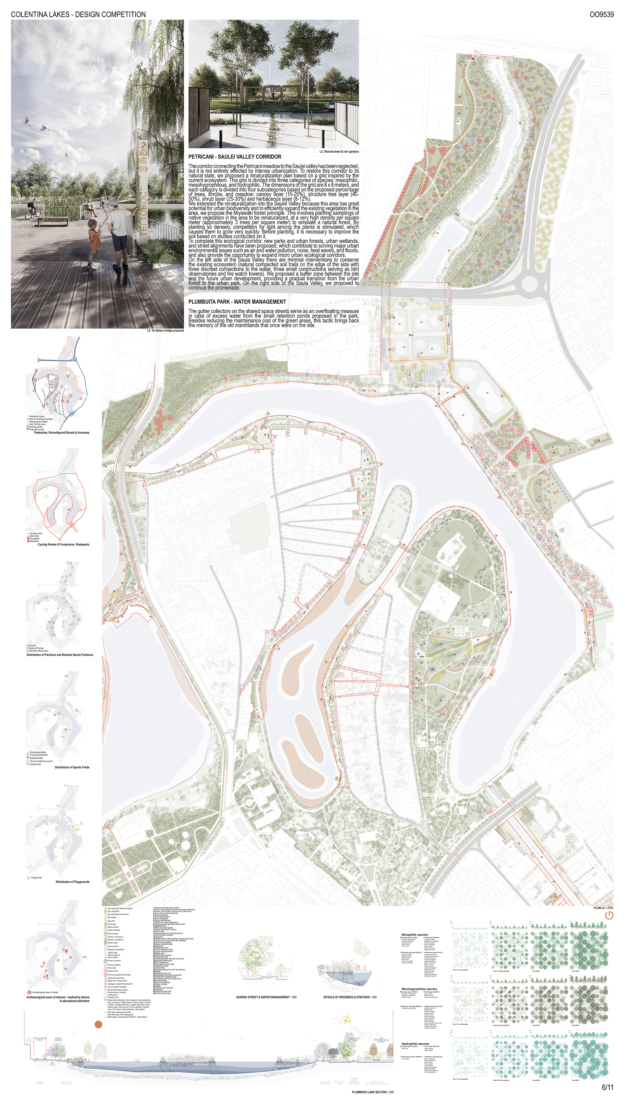
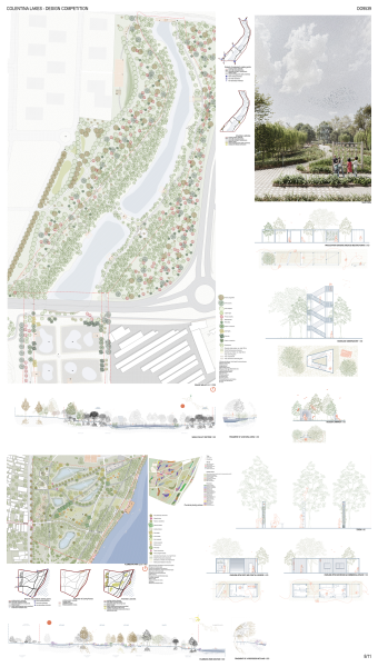
PETRICANI – SAULEI VALLEY CORRIDOR
The corridor connecting the Petricani meadow to the Saulei valley has been neglected, but it is not entirely affected by intense urbanization. To restore this corridor to its natural state, we proposed a renaturalization plan based on a grid inspired by the current ecosystem. This grid is divided into three categories of species: mesophilic, mesohygrophilous, and hydrophilic. The dimensions of the grid are 8 x 8 meters, and each category is divided into four subcategories based on the proposed percentage of trees, shrubs, and meadow: canopy layer (15-20%), structure tree layer (40-50%), shrub layer (25-30%) and herbaceous layer (8-12%).
We extended the renaturalization into the Saulei Valley because this area has great potential for urban biodiversity and to efficiently expand the existing vegetation in the area, we propose the Miyawaki forest principle. This involves planting saplings of native vegetation in the area to be renaturalized, at a very high density per square meter (approximately 3 trees per square meter) to simulate a natural forest. By planting so densely, competition for light among the plants is stimulated, which causes them to grow very quickly. Before planting, it is necessary to improve the soil based on studies conducted on it.
To complete this ecological corridor, new parks and urban forests, urban wetlands, and street alignments have been proposed, which contribute to solving major urban environmental issues such as air and water pollution, noise, heat waves, and floods, and also provide the opportunity to expand micro urban ecological corridors.
PLUMBUITA PARK – WATER MANAGEMENT
The gutter collectors on the shared space streets serve as an overfloating measure in case of excess water from the small retention ponds proposed in the park. Besides reducing the maintenance cost of the green areas, this tactic brings back the memory of the old marshlands that once were on the site.
LOT 3 – 2nd PRIZE
“ This team proposed discrete, neutral interventions which the jury felt were feasible and realistic schemes. The careful insertion of the built elements in the natural environment was noted. The proposals illustrated good connectivity to the surrounding neighborhoods. The response to the canal portion of the project was appreciated as intensifying the visitor experience and enlarging the space at the end of the canal. The response to Colentina Park showed a good balance between the existing and the proposed. This team found hidden spaces within the scheme to activate and enhance. Overall, the jury felt that there was not enough innovation and original thinking in this scheme compared to the winner.” – appreciation of the Jury
The 6 Colentina lakes are part of a network of 15 lakes: an ecological corridor (that were once an agglomeration of swamps, wetlands and prolific ecosystems) that crosses the capital city. Today these lakes are known as a destructured and sloppy membrane, which fails to bring the city and the new developments of Bucharest and Ilfov county closer together. Even so, these lakes’ potential was appreciated even before the major landscaping works that started in 1933. The historical images illustrate that the lakes had a rich natural character, being mostly used for recreation and leisure (water sports, fishing and even bathing).
The main purpose of this proposal is to create a continuous pedestrian and cycling circuit based on a network of architectural and natural elements that aims to facilitate spatial orientation, to encourage social equity and to easily connect the city with the ecological corridor of the Colentina lakes, which are located in a heterogeneous urban tissue that is sometimes destructured or even peri-urban. This network tries to insert itself naturally and non-intrusively into the existing natural environment or the recent urban developments, while offering public amenities that serve as urban activators.
These activators will encourage social interactions like meetings amongst neighbors, locals and why not, tourists, through sports, leisure, cultural and educational activities, all of them happening outside. Besides these architectural or rather functional aspects of our proposal, the main focus lies on conserving the existing landscape and restoring the ecosystem, but also expanding its natural riparian areas and connecting its local communities (human, animal or floral) with the water and with each other. Therefore, our proposal enhances mostly the Petricani – Valea Saulei ecological corridor.
The project aims to combine functionality with aesthetics, challenging stereotypes about water quality, improving local residents’ lives, encouraging public engagement and direct water interaction.
Network of architectural and natural elements:
We propose a range of custom-made urban and landscape design elements with a unitary and coherent general image, but showing differences at a micro level (colors, functionalities) adapted to each lake:
- Multi-purpose totems: specific design elements that have both an educational and informative purpose (maps, orientation directions, historical & archaeological information as well as information about specific fauna and flora) as well as an ecological purpose, serving as houses for birds and insects or thirst-quenching areas for dogs and cats.
- Pavilions, playgrounds & pontoons: having the same architectural language, differentiated by color.
- Totem trees: 3-5 recognizable landmark trees that accentuates important entrances or intersections.
Ranking the amenities and proposed spaces:
The distribution of entrances and areas was carefully thought out to serve a local interest, the neighborhood or the entire sector, taking into account the pedestrian movement of the users, while maintaining the existing character.
Local: a pavilion / playground/ rest area / small sport area – between 150m. – 300m. from each other – 5 minutes of walking
Neighborhood areas: large playgrounds / event areas / sports areas – between 300m.-500m. from each other – 10-15 minutes of walking
Sector areas: major parks & gardens – between 600m.-1000m. from each other – 15-20 minutes of walking
Entrances: both existing & new ones – between 150m. – 300m. from each other – 5 minutes of walking
Continuous pedestrian & bike circuit (promenade) framework for the proposed network: playgrounds, meeting places for breaks and social interaction, places to relax and sunbathe, special places for dogs, for urban sports or for seniors, pontoons for water sports or for fishing, swimming ponds.
- The promenade has a constant width of 4m (including the bike lane, without differentiating the level or texture) to allow permanent technical and emergency access.
- This continuous circuit can also be used for organizing sports competitions – runs of 5km, 10km, 21km or 42km (marathon), cycling competitions, skate or roller circuits stimulating movement in the city.
- This circuit can be a basis for triathlon competitions – cycling, running and open-water swimming. The layout, design and fair distribution of the pavilions and pontoons will provide the necessary framework to organize these competitions on a local scale.
- The elements are proposed on a small scale to prevent agglomerations of people in very large numbers and to preserve the existing natural and quiet character of the area. The promenade with its elements act as an active membrane between the city and the water and thus resumes the original role of the Colentina lakes.
The quality of the proposed promenade depends on the water quality, both aesthetically (water degradation) and functionally (floodability, humidity, and air quality). Given Bucharest’s climate challenges and public perception, the project proposes:
Reversing Water Eutrophication:
For small areas on Tei Lake, Colentina, and Fundeni: a minimal passive reedbed system for plant-based water oxygenation and light infiltration prevention.
In advanced eutrophication zones (Plumbuita Lake): a sustainable biofiltration system with passive reedbed management and two oxygenating fountains.
Floodability, Humidity, and Air Quality:
In flood-prone parks and natural areas: permeable pathways and urban forests for soil stabilization, water retention, and improved air quality.
In urban areas: collector gutters with hydrocarbon filters, doubling as aesthetic elements on narrow streets, redirecting water to local wetlands.
Rain gardens and retention ponds enhance biodiversity while improving air quality.
Restoring an ecosystem:
In the case of an ecosystem, this means restoring both its quantity and its quality, especially as regards its physical state, its chemical state, its species composition, its structure, and its ability to function as a complex interconnected habitat taking into account external influences. The restoration process begins as soon as the restoration measures have been put in place, but this does not immediately result in the ecosystems reaching a good condition. It could take some time before the ecosystem reaches that stage.
This is because different habitats recover at different rates. Experience has shown that a river or floodplain, for instance, might take a few years to reach its full ecological potential. A natural forest, raised bog or dry grassland, on the other hand, could take several decades or more to regain the full complex mix of plant and animal species that characterize it.
Restored sites should also be protected from degrading again to ensure they reach and are maintained in a good condition. The EU Biodiversity Strategy commits EU Member States to protect 30% of the EU territory for nature by 2030, of which 10% should be strictly protected. Restoration should therefore work hand in hand with this protection target to maximize the benefits.
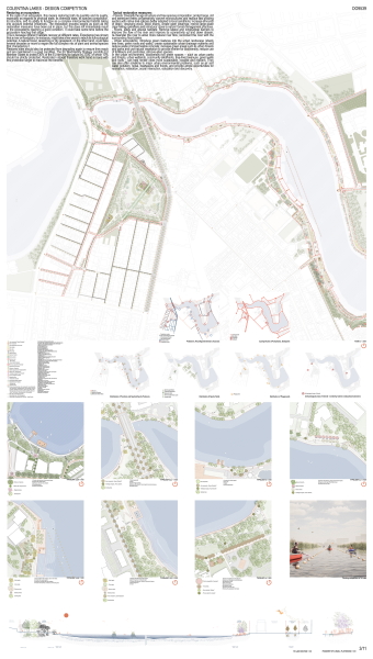
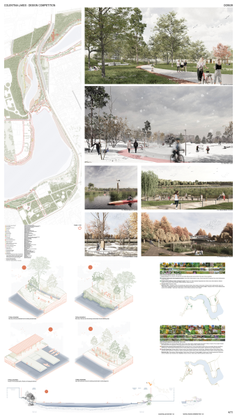
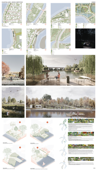
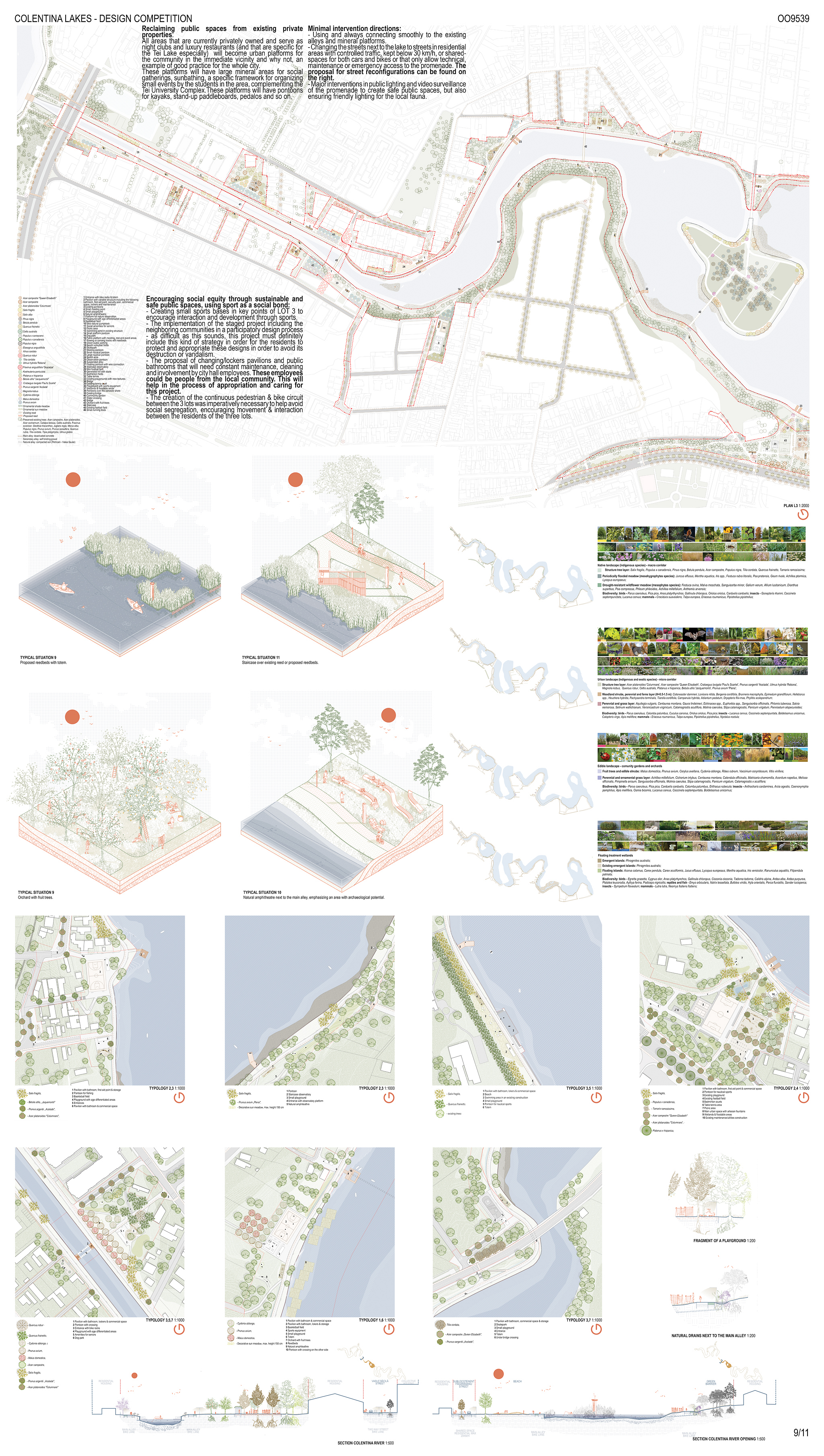
Reclaiming public spaces from existing private properties:
All areas that are currently privately owned and serve as night clubs and luxury restaurants (and that are specific for the Tei Lake especially) will become urban platforms for the community in the immediate vicinity and why not, an example of good practice for the whole city.
These platforms will have large mineral areas for social gatherings, sunbathing, a specific framework for organizing small events by the students in the area, complementing the Tei University Complex.These platforms will have pontoons for kayaks, stand-up paddleboards, pedalos and so on.
Minimal intervention directions:
- Using and always connecting smoothly to the existing alleys and mineral platforms.
- Changing the streets next to the lake to streets in residential areas with controlled traffic, kept below 30 km/h, or shared-spaces for both cars and bikes or that only allow technical, maintenance or emergency access to the promenade. The proposal for street reconfigurations can be found on the right.
- Major interventions in public lighting and video surveillance of the promenade to create safe public spaces, but also ensuring friendly lighting for the local fauna.
Encouraging social equity through sustainable and safe public spaces, using sport as a social bond:
- Creating small sports bases in key points of LOT 3 to encourage interaction and development through sports.
- The implementation of the staged project including the neighboring communities in a participatory design process – as difficult as this sounds, this project must definitely include this kind of strategy in order for the residents to protect and appropriate these designs in order to avoid its destruction or vandalism.
- The proposal of changing/lockers pavilions and public bathrooms that will need constant maintenance, cleaning and involvement by city hall employees. These employees could be people from the local community. This will help in the process of appropriation and caring for this project.
- The creation of the continuous pedestrian & bike circuit between the 3 lots was imperatively necessary to help avoid social segregation, encouraging movement & interaction between the residents of the three lots.