





112 – TU3737 – NORMA ARHITECTURĂ ȘI URBANISM SRL, BOCA ȘTEFANIA-LILIANA BIA, RECREATIV ARHITECTURA PEISAGERA SRL


Main Author: Boca Ștefania Liliana, Fleșeriu Alexandru Nicolae, Kotro-Kosztandi Anna, Olteanu Alexandra, Péter Alexandra, Péter Eszter, Uglea Claudia Andreea
Specialty collaborators: Water management specialist Tetelea Cristian Demostene
“The project stands out for its clear urban gesture and consistent design approach. In contrast to the treeless esplanade along the Danube, Mircea Square is envisioned as a vibrant green space, populated with a diverse mix of tree species. The newly proportioned square is designed to appear like a clearing within the “urban forest”, offering a strong spatial identity and sense of place.
The square is paved entirely with cobblestones, using a combination of reclaimed and new materials, ensuring durability, a high-quality aesthetic, but also emphasizing a commitment to local heritage.
The proposal demonstrates a deep understanding of the site, addressing its historical foundations while incorporating memory-based design gestures. The water management strategy and planting concept are well considered, creating a dialogue not only with the historic city but also with the modern urban context.” – appreciation of the Jury
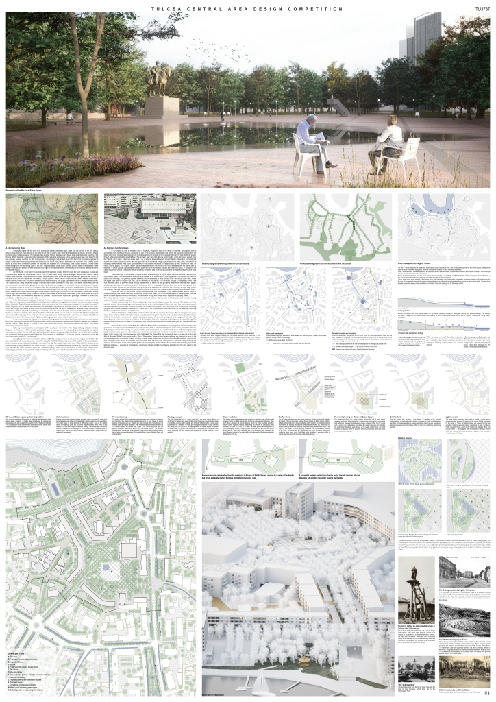
A City Formed by Water
Our project begins with the study of an existing, yet scarcely perceptible layer. Maps from the first half of the 19th century depict a city surprisingly unlike the one we see today. In the area of today’s urban center, the maps depict an estuary – or liman – shaped by the Danube’s restless presence. The Holocene Delta sculpted Tulcea’s topography and its soft soils, while the ancient branches of the Danube (Sfântu Gheorghe, Sulina, and Chilia) interlaced with this estuarine landscape to form a dense, aqueous web. Over time, this gulf was gradually covered, and from the 19th century onward, the city began to build itself upon it. We found that the lowest-lying areas of today’s Tulcea trace with uncanny precision the contours of that former watery terrain, depicted in the 1830 map. Thus, Tulcea’s center stands on a land once surrendered to water. For centuries, this area was not a defined edge, but a mutable threshold, a liminal space where solid ground met the shifting pulse of the river. Regina Elisabeta Street (today Corneliu Gavrilov Street) and Basarabiei Street (today Păcii Street) are believed to have formed two soft edges of the historic shoreline, often flooded by the river and flanking the banks of the former estuary.
As with the city, so too were the people shaped by the presence of water. Even time itself, the way it was sensed, marked, and understood, was inseparable from the natural world. Time in Tulcea flowed through multiple languages, calendars, and cultures. Jewish traders, Greek mariners, Turkish artisans, and Lipovan fishermen each moved to their own temporal cadences, guided by tide, rainfall, by the cycles of sun and moon. By the late 19th century, a simple question – “What time is it?”-might elicit the answer: “Alaturka or alafranka?” Muslim time or Christian time? For the city’s Muslims, time was anchored in daily prayer, calibrated to the sun’s passage across the sky. The muezzin’s call, rising above the rooftops, functioned as a public timekeeper-a living clock. For Jewish communities, the day commenced with the evening’s first glimpse of the moon. For Christians, time began at sunrise, the first hour marked by dawn. The port, too, had its own tempo. At sunrise, the streets were filled with the creaking of wooden carts rolling steadily toward the Danube. During times of drought, fishermen and traders from Isaccea could travel along a route that today bears the name Isaccea Street. On the map above, it appears as a dotted line, indicating that it was passable only during dry periods. When the water levels in the Danube’s estuary rose too high, merchants were forced to alter their course. Tulcea followed a natural tempo: fluid, messy, plural, and unhurried. In a city of multiple communities and multiple times, water was the constant. It dictated routes, rhythms and gatherings. There was no single clock, until later on – only the sun, the river, and the sky.
In the 19th century, the city began to change. The former estuary was completely covered with stone and rockery, and by the mid-1800s, new urban zones emerged-Ceair (now the city center) and Ceamuria (roughly the area between the quay and today’s Isaccea Street). Streets like Regina Elisabeta and Basarabiei, which once bordered the former estuary, were paved with the so-called “red marble.” Strada Progresului and the Bazaar also appeared, while Babadag and Isaccea streets extended across land that had once been water. Carol Park emerged too-Tulcea’s very own Corso, a promenade of urban life. The spirit of these streets, especially through their interwar architecture, embodied a more European image of a historical center. The newly built streets were paved with cobbled stone, known in Turkish as caldarâm or kaldarîm. More refined streets like 14 Noiembrie Street were covered with macadam. The Ottomans adapted the well known scottish technique of the macadam with two compacted layers of broken stone: the upper finer and tamped while still wet. Together, the streets of the city wove a web of gutters and drainage systems, guiding water through the city.
In more recent history, the city centre has hardened. Drainage systems were buried and the soft earth was covered in asphalt, thus public space forgot how to absorb. During the socialist period the city center was reshaped again Danube’s presence was contained, drained, bordered. Water became a problem to solve, not a presence to live with. Greenery was trimmed and aligned. Time turned linear and space became mineral.

Following the administrative decentralization of the country and the creation of the Regional Design Institutes (Institute Regionale de Proiectare – I.R.P.), socialist architecture began to pursue a form of local specificity, a discourse that only gained mainstream momentum after the 1967 plenary of the Union of Architects. In secondary cities like Tulcea, the so-called local specificity was represented through generic, symbolic gestures. The colonnade on Unirii Street, in Tulcea for instance, was meant to evoke the atmosphere of the old bazaar, but only faintly.
During this period, the new civic square (Mircea cel Bătrân) was conceived as a vast, open void, largely detached from the older urban fabric. Like many interventions across Romania after the 1958-1959 planning decrees that established the systematization sketch, this civic centre proclaimed itself as the new heart of the city. The socialist vision of the early 1960s called for development to begin within the existing urban fabric and radiate outward. In doing so, it overlaid itself onto the historical city, becoming an “ordering” layer. After the fall of the communist regime, the socialist layer began to be seen as an obstacle. Its monumental emptiness was increasingly questioned, its form gradually reshaped. Ironically, what was once a tool of erasure became, in turn, subject to erasure.
An Approach that Remembers
In our project, we seek to resist this cycle of forgetting, recognizing each of the layers as essential. Our proposal aims to acknowledge their conflicts, intentions, and traces as part of the complex sedimentation that defines the city today. Starting from the former estuary, our proposal reopens the ground to what has always lain beneath it. We propose to listen, and to trace the former estuary through subtle topographies that slow the flow of the rainwater, open joints that allow the soil to breathe, and to reintroduce shaded areas that hold the rain in place. Tulcea has always been a city of balance: between flood and drought, hillside and wetland, community and solitude. We believe that the city centre can once again learn to live with water through a public space that filters, slows, and collects – a landscape that remembers. Here, public space becomes a living system: responsive to change, shaped by time, designed for water, for nature, and for people. This biophilic design approach responds to both the needs of the city’s inhabitants and the natural logic of rainwater — whose growing unpredictability in recent years has led to increasingly frequent and hazardous floods. In reimagining the central square, we uncover a hotspot for the city’s renewal, the central area of the city is a point zero where an eco-resilient future might begin.
The socialist layer is reinterpreted through a renewed understanding of its original spatial intentions. We draw inspiration from the pavement layout of Mircea cel Bătrân Square, once envisioned as an ordered grid—a defining gesture of the socialist city, meant to assert a new civic logic. This geometry signaled openness and monumentality, in sharp contrast to the 19th-century urban fabric, where the largest voids were the bazaar, Păcii Park, and the riverbanks of the Danube. In our proposal, this grid is recomposed, woven anew from alternating bands of pavement and a carefully planted matrix of trees. The new grid gently reframes the vastness of the square, establishing a soft edge and restoring a sense of intimacy and rhythm to a space that had long been monumental and exposed. At its heart, a central void is preserved—an intentional clearing for gathering, adaptation, and collective use. It becomes an open stage for civic life, while also offering a respectful pause within the layered histories of the site. Here, one can observe traces of Regina Elisabeta Street.
Around the void, the tree-covered zones introduce slowness and permanence. These shaded pockets become places of stillness, reflection, and retreat—balancing the openness of the central space with the contemplative quiet of planted ground. The new Mircea cel Bătrân Square is not built from scratch, but transformed through what already exists: vegetation, topography, traces.
The existing planted areas are reimagined as retention ponds and gardens, allowing water to collect, pause, and permeate—turning ecological function into spatial expression.
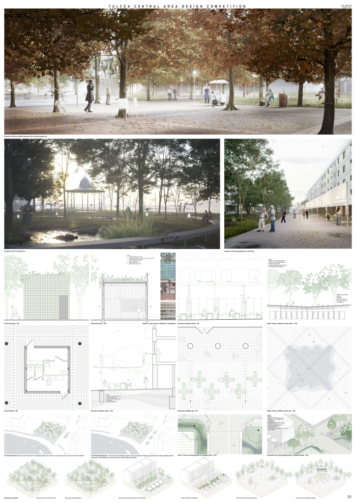
The grid extends toward Unirii Street, establishing a direct spatial dialogue between the two areas. This gesture reinforces continuity between two previously fragmented areas of the city center, transforming Unirii Street into more than just a transit route, it becomes a space of movement and encounter. A corridor for circulation, conversation, and civic energy, while simultaneously continuing the green spine of trees and swales toward the Trei Fântâni area. In this way, ecological function and urban life are interwoven, redefining the street as both connective tissue and public space.
The Trei Fântâni area is both spatially enriched and imbued with new meaning. The paved surface is reimagined as a gently sloped terrain that draws the three fountains closer to the public, transforming them into an interactive landscape. No longer distant objects of display, the fountains become part of a playable topography—a space of movement, cooling, and direct engagement with water. The sloped geometry invites both children and adults to inhabit the space differently, responding to light, sound, and seasonal change. The pavement itself is composed of a blend of recovered and new materials: reclaimed stones from the existing site are integrated with new cobbles.
Once part of the historic Carol I Park, the Trei Fântâni Park remains one of the few surviving fragments of Tulcea’s early public green areas. Our proposal preserves this memory, subtly reshaping it into a coherent, contemporary park, a water garden that embraces its hydrological context while honoring its layered past. The park is reimagined as a retention landscape, a soft, shaded garden that functions as both public space and water infrastructure. At its heart, a circular bench recalls the ornamental circle that once anchored the former “public garden,” lost during the expansion of the Delta Hotel. Trei Fântâni Park also becomes the home of a new cultural axis—the Alley of Minorities. While Tulcea already hosts a “Park of Personalities,” where busts of prominent figures are displayed, a group of five busts representing five personalities of ethnic minorities currently stands isolated in a roundabout (Minorities’ Roundabout), disconnected from meaningful public context. Our proposal repositions these busts within the park, offering them a dedicated setting of dignity and reflection. The redesigned park is not an isolated gesture. A proposed green corridor links it to the broader riverbank, offering the potential for future continuity—a sequence of ecological and civic pockets stitched together by landscape, extending from the city’s interior to the Danube’s edge.