


117 – CC1752 – POSTER SRL
Main authors: Irina Meliță, Ștefan Simion, Claudia Ileana Trufaș, Cristian Andrei Bădescu
Coauthors: Luca Misosniky, Elena Florea
Specialty collaborators: peis. Cornelius Gavril
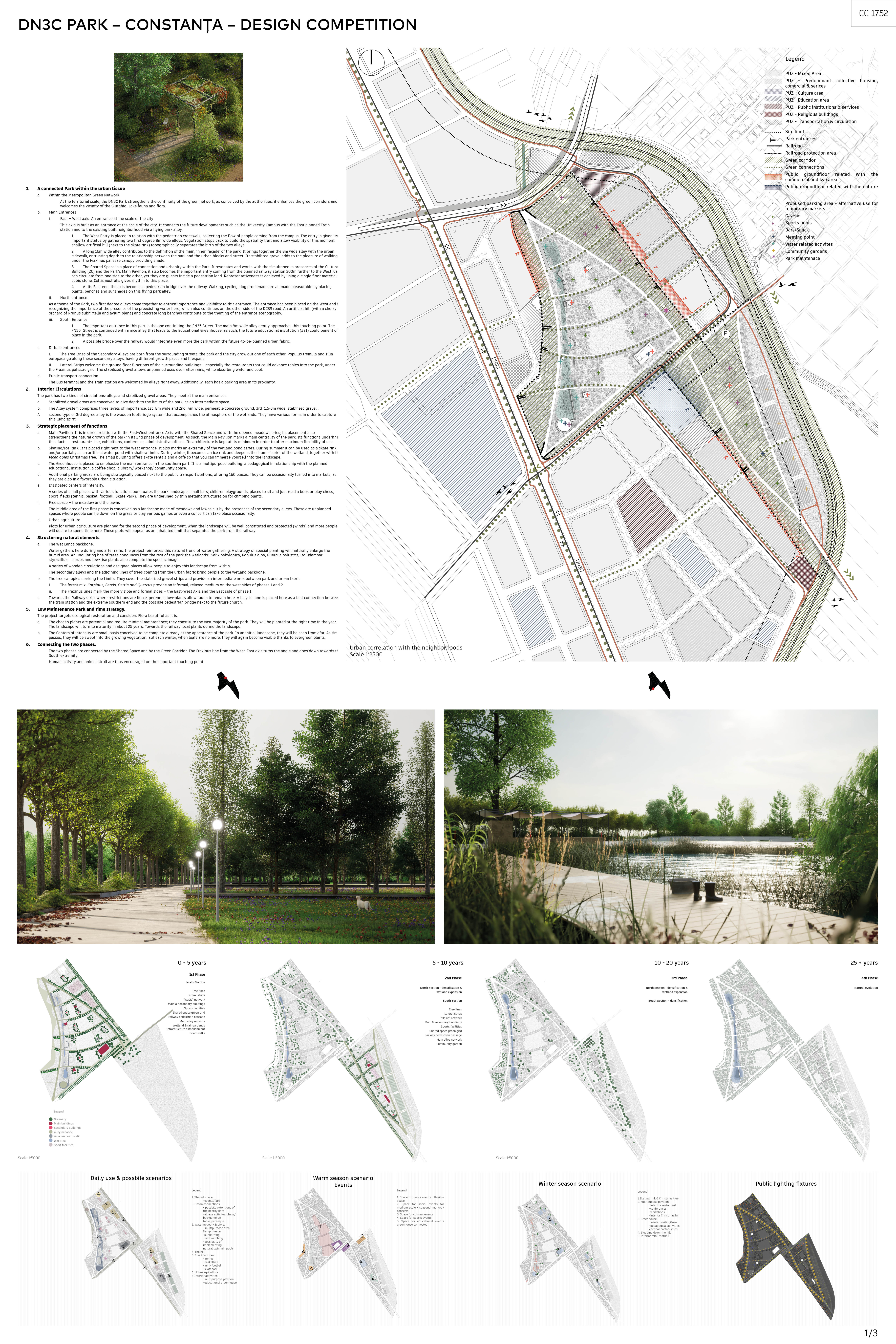
A connected Park within the urban tissue
- Within the Metropolitan Green Network
At the territorial scale, the DN3C Park strengthens the continuity of the green network, as conceived by the authorities: it enhances the green corridors and welcomes the vicinity of the Siutghiol Lake fauna and flora.
- Main Entrances
- East – West axis. An entrance at the scale of the city
This axis is built as an entrance at the scale of the city. It connects the future developments such as the University Campus with the East planned Train station and to the existing built neighborhood via a flying park alley.
- The West Entry is placed in relation with the pedestrian crosswalk, collecting the flow of people coming from the campus. The entry is given its important status by gathering two first degree 8m wide alleys. Vegetation steps back to build the spatiality trait and allow visibility of this moment. A shallow artificial hill (next to the skate rink) topographically separates the birth of the two alleys.
- A long 16m wide alley contributes to the definition of the main, inner ‘façade’ of the park. It brings together the 8m wide alley with the urban sidewalk, entrusting depth to the relationship between the park and the urban blocks and street. Its stabilized gravel adds to the pleasure of walking under the Fraxinus palissae canopy providing shade.
- The Shared Space is a place of connection and urbanity within the Park. It resonates and works with the simultaneous presences of the Cultural Building (ZC) and the Park’s Main Pavilion; it also becomes the important entry coming from the planned railway station 200m further to the West. Cars can circulate from one side to the other, yet they are guests inside a pedestrian land. Representativeness is achieved by using a single floor material: cubic stone. Celtis australis gives rhythm to this place.
- At its East end, the axis becomes a pedestrian bridge over the railway. Walking, cycling, dog promenade are all made pleasurable by placing plants, benches and sunshades on this flying park alley.
- North entrance.
As a theme of the Park, two first degree alleys come together to entrust importance and visibility to this entrance. The entrance has been placed on the West end in recognizing the importance of the presence of the preexisting water here, which also continues on the other side of the DC89 road. An artificial hill (with a cherry orchard of Prunus subhirtella and avium plena) and concrete long benches contribute to the theming of the entrance scenography.
- South Entrance
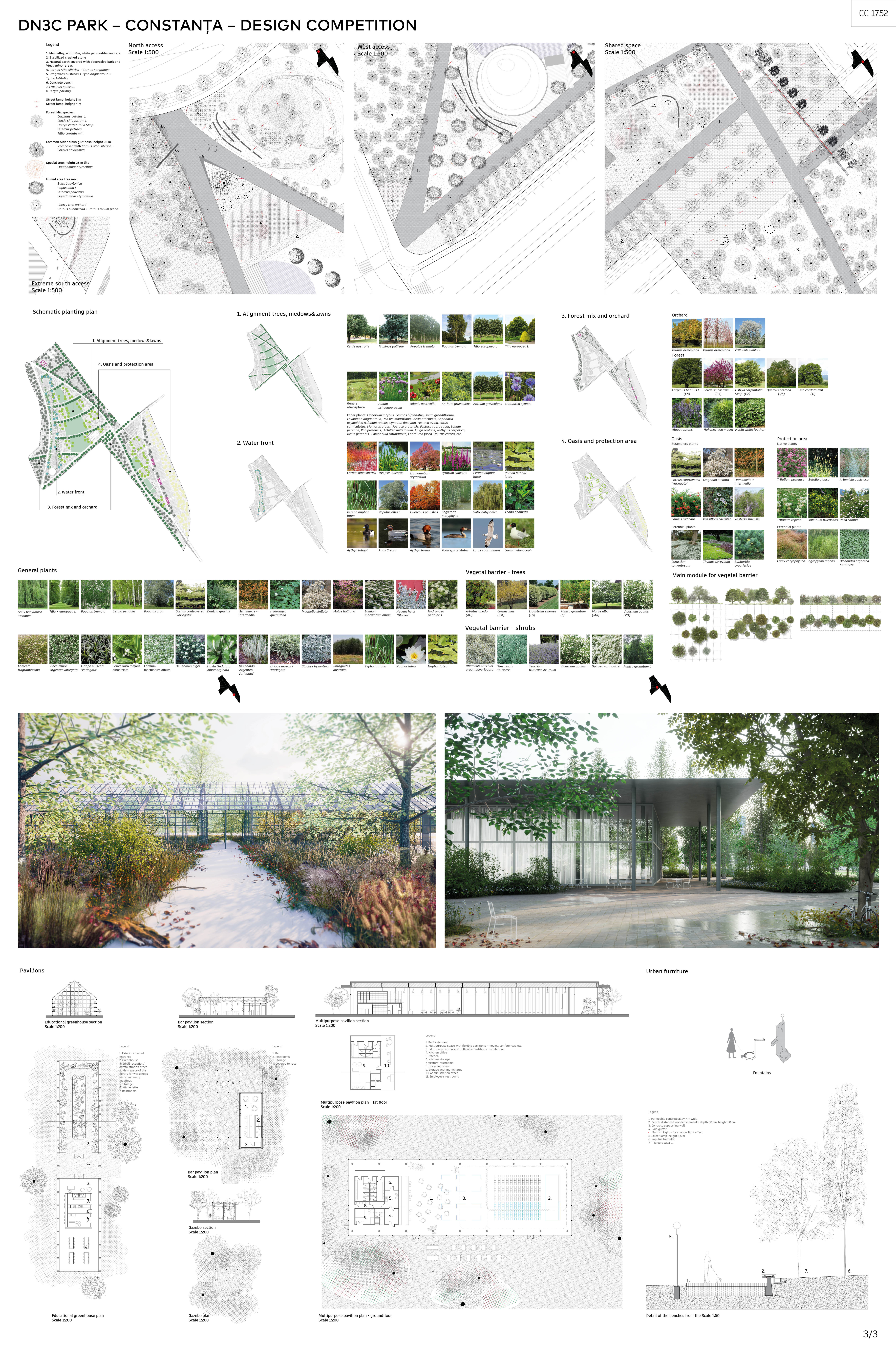
- The important entrance in this part is the one continuing the FN35 Street. The main 8m wide alley gently approaches this touching point. The FN35 Street is continued with a nice alley that leads to the Educational Greenhouse; as such, the future educational institution (ZE1) could benefit of a place in the park.
- A possible bridge over the railway would integrate even more the park within the future-to-be-planned urban fabric.
- Diffuse entrances
- The Tree Lines of the Secondary Alleys are born from the surrounding streets: the park and the city grow out one of each other. Populus tremula and Tilia europaea go along these secondary alleys, having different growth paces and lifespans.
- Lateral Strips welcome the ground floor functions of the surrounding buildings – especially the restaurants that could advance tables into the park, under the Fraxinus palissae grid. The stabilized gravel allows unplanned uses even after rains, while absorbing water and cool.
- Public transport connection.
The Bus terminal and the Train station are welcomed by alleys right away. Additionally, each has a parking area in its proximity.
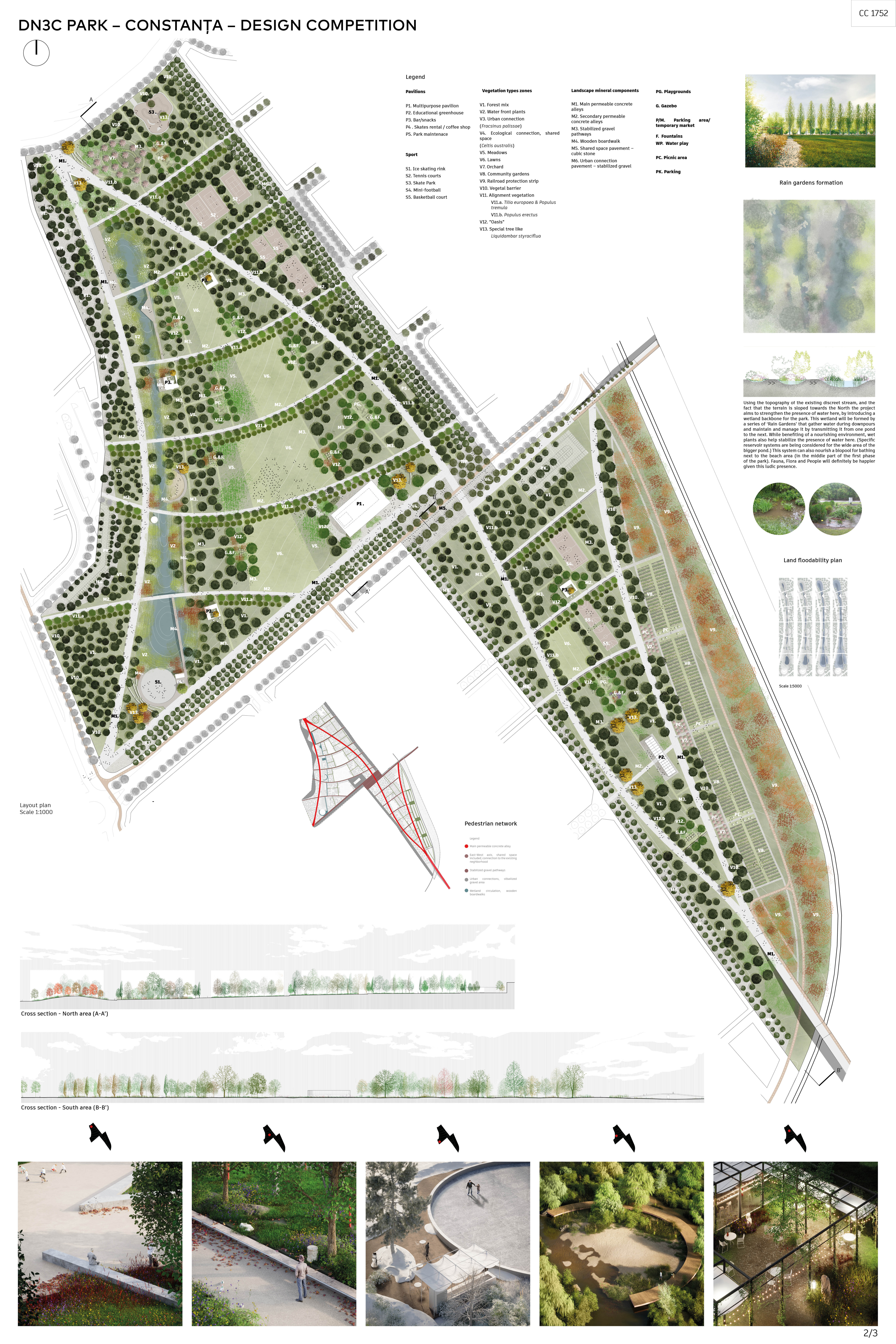
- Interior Circulations
The park has two kinds of circulations: alleys and stabilized gravel areas. They meet at the main entrances.
- Stabilized gravel areas are conceived to give depth to the limits of the park, as an intermediate space.
- The Alley system comprises three levels of importance: 1st_8m wide and 2nd_4m wide, permeable concrete ground; 3rd_1,5-3m wide, stabilized gravel .
A second type of 3rd degree alley is the wooden footbridge system that accomplishes the atmosphere of the wetlands. They have various forms in order to capture this ludic spirit.
- Strategic placement of functions
- Main Pavilion. It is in direct relation with the East-West entrance Axis, with the Shared Space and with the opened meadow series; its placement also strengthens the natural growth of the park in its 2nd phase of development. As such, the Main Pavilion marks a main centrality of the park. Its functions underline this fact: restaurant-bar, exhibitions, conference, administrative offices. Its architecture is kept at its minimum in order to offer maximum flexibility of use.
- Skating/Ice Rink. It is placed right next to the West entrance. It also marks an extremity of the wetland pond series. During summer it can be used as a skate rink and/or partially as an artificial water pond with shallow limits. During winter, it becomes an ice rink and deepens the ‘humid’ spirit of the wetland, together with the Picea abies Christmas tree. The small building offers skate rentals and a café so that you can immerse yourself into the landscape.
- The Greenhouse is placed to emphasize the main entrance in the southern part. It is a multipurpose building: a pedagogical in relationship with the planned educational institution, a coffee shop, a library/ workshop/ community space.
- Additional parking areas are being strategically placed next to the public transport stations, offering 160 places. They can be occasionally turned into markets, as they are also in a favorable urban situation.
- Dissipated centers of intensity.
A series of small places with various functions punctuates the park landscape: small bars, children playgrounds, places to sit and just read a book or play chess, sport fields (tennis, basket, football, Skate Park). They are underlined by thin metallic structures on for climbing plants.
- Free space – the meadow and the lawns
The middle area of the first phase is conceived as a landscape made of meadows and lawns cut by the presences of the secondary alleys. These are unplanned spaces where people can lie down on the grass or play various games or even a concert can take place occasionally.
- Urban agriculture
Plots for urban agriculture are planned for the second phase of development, when the landscape will be well constituted and protected (winds) and more people will desire to spend time here. These plots will appear as an inhabited limit that separates the park from the railway.
- Structuring natural elements
- The Wet Lands backbone.
Water gathers here during and after rains; the project reinforces this natural trend of water gathering. A strategy of special planting will naturally enlarge the humid area. An undulating line of trees announces from the rest of the park the wetlands: Salix babylonica, Populus alba, Quercus palustris, Liquidambar styraciflua; shrubs and low-rise plants also complete the specific image.
A series of wooden circulations and designed places allow people to enjoy this landscape from within.
The secondary alleys and the adjoining lines of trees coming from the urban fabric bring people to the wetland backbone.
- The tree canopies marking the Limits. They cover the stabilized gravel strips and provide an intermediate area between park and urban fabric.
- The forest mix. Carpinus, Cercis, Ostria and Quercus provide an informal, relaxed medium on the west sides of phases 1 and 2.
- The Fraxinus lines mark the more visible and formal sides – the East-West Axis and the East side of phase 1.
- Towards the Railway strip, where restrictions are fierce, perennial low-plants allow fauna to remain here. A bicycle lane is placed here as a fast connection between the train station and the extreme southern end and the possible pedestrian bridge next to the future church.
- Low Maintenance Park and time strategy.
The project targets ecological restoration and considers Flora beautiful as it is.
- The chosen plants are perennial and require minimal maintenance; they constitute the vast majority of the park. They will be planted at the right time in the year. The landscape will turn to maturity in about 25 years. Towards the railway local plants define the landscape.
- The Centers of intensity are small oasis conceived to be complete already at the appearance of the park. In an initial landscape, they will be seen from afar. As time passes, they will be swept into the growing vegetation. But each winter, when leafs are no more, they will again become visible thanks to evergreen plants.
- Connecting the two phases.
The two phases are connected by the Shared Space and by the Green Corridor. The Fraxinus line from the West-East axis turns the angle and goes down towards the South extremity.
Human activity and animal stroll are thus encouraged on the important touching point.