


121 – JD1986 – PRÁCTICA ARQUITECTURA Y URBANISMO SLP
Main authors: Práctica Arquitectura y Urbanismo S.L.P. (Jaime Daroca, José Mayoral and José Ramón Sierra)
Architecture collaborators: Raul Brito, Sarah Aillón, Costan Svinti and Iván Iglesias

Establishing a balance between habitats for people and habitats for flora and fauna, this project aims to foster biodiversity through varied ecosystems, invite a diverse range of people to use the space through different programs and celebrate the surrounding context through a responsive design.
First and foremost, the park DN3C acts as an ecological hub that anchors the green network within Constanța and creates varied ecological habitats to support biodiversity. Leveraging existing conditions, the project works with, not against, the topography and mitigates the strong winds prevalent in the area to create comfortable microclimates.
Additionally, the park DN3C holds the potential to serve as an urban connector, linking the existing and future bike network and pedestrian paths and amplifying surrounding uses and developments. The design creates different scaled green “rooms” that serve as platforms to support day-to-day activities to larger special events, across all seasons. From providing moments of respite to serving as a city-wide asset, the park offers a multitude of invitations to spend time, for residents and visitors alike.
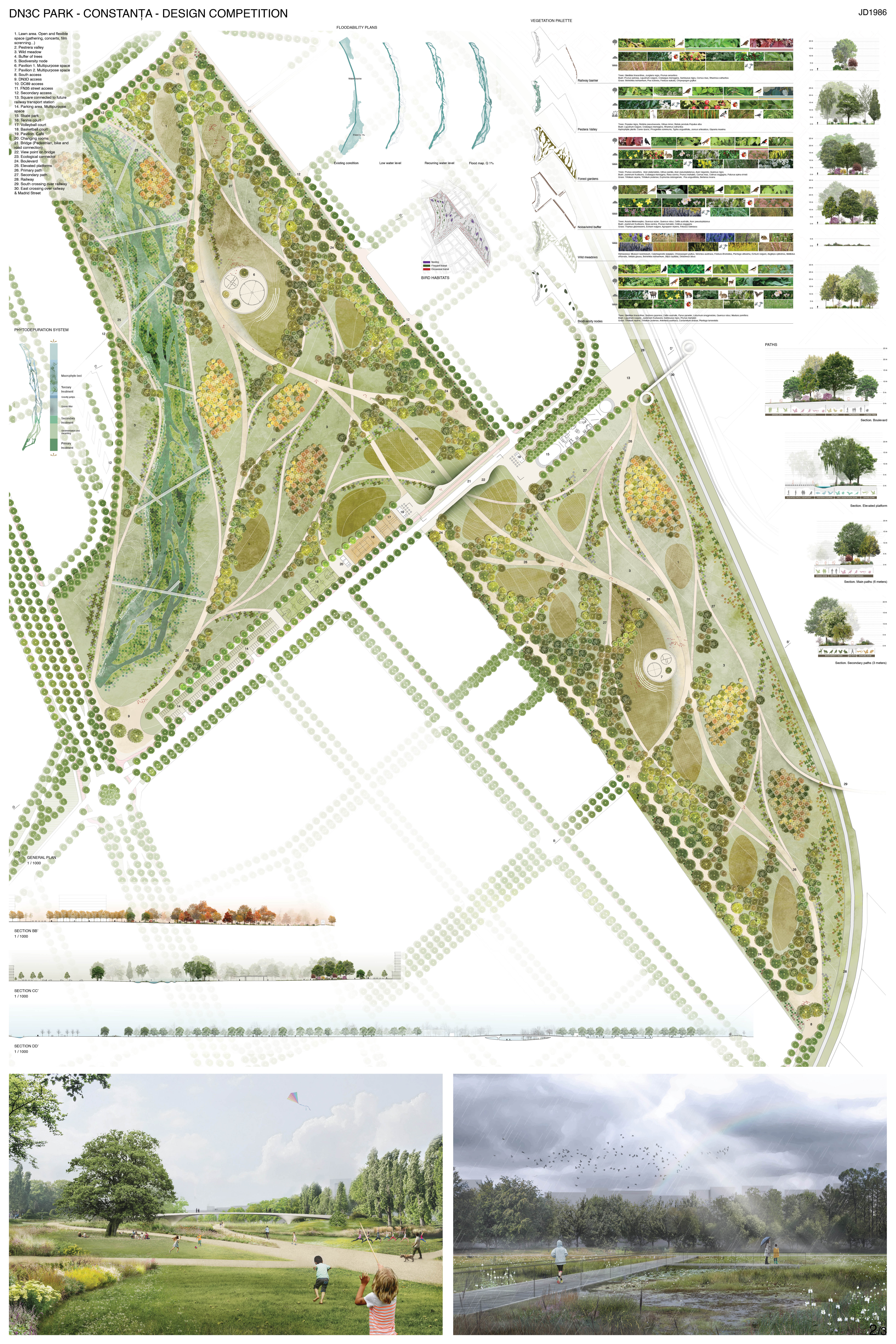
1. Ecological Hub
The park DN3C is envisioned as a key node that reinforces the existing network of green areas within the city of Constanța and serves as a continuation of the green corridors. Thus, the project supports a system of biodiverse nodes that are close to each other to guarantee the continuity of ecological habitats.
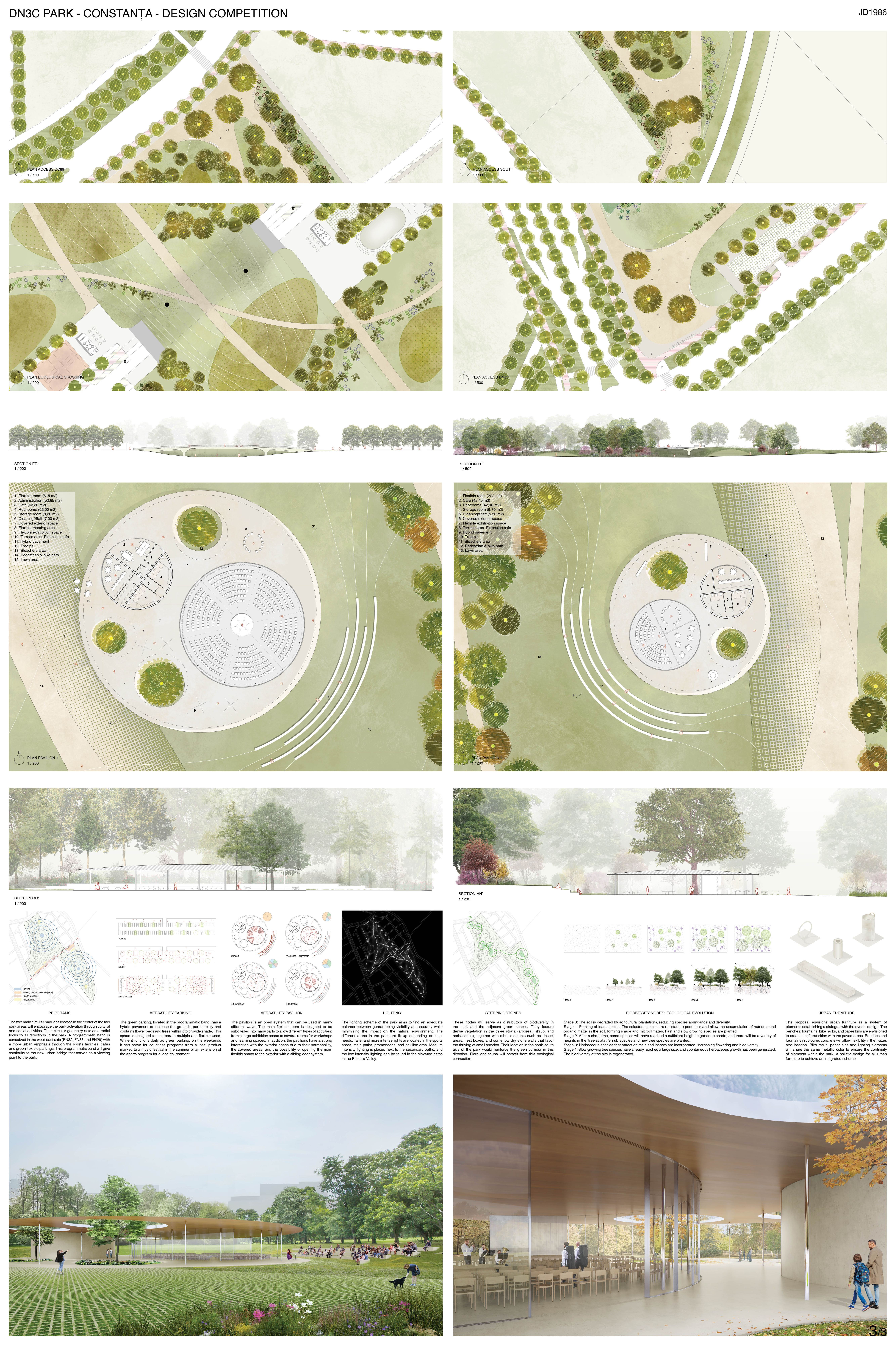
The wind, a fundamental natural input, becomes an important design strategy that shapes the park. A buffer of trees with species such as Acer platanoides and Quercus nigra, among others, is proposed on the two sides adjacent to the residential areas. This tree buffer extends from the site boundaries into the center of the park with a finger-like elongation system that protects from north and west winds as well as blizzard conditions. The buffer acts to create a comfortable microclimate while simultaneously mitigating the noise and allowing for pockets with greater levels of privacy.
The Pestera Valley is a vital park area due to its topography and hydrological nature. As such, the design emphasizes the character of the area by highlighting the topography with an extensive system of water courses that allows for the increase of water transport to the valley, emphasizing its wetland ecosystem and integrating a phytodepuration system for natural purification with the use of species such as Phragmites communis, Typha angustifolia and Juncus articulatus.
Focusing on species that recondition the soil by providing nutrients, the vegetation palette has been curated to allow for the future development of new species while increasing the biodiversity and supporting a greater range of fauna in the area. The species have been carefully selected based on certain performance capacities and attributes, such as their capacity to serve as a wind barrier or their water requirements in the Pestera Valley.
The park is designed with the awareness of limited resources. For this reason, the maintenance cost is taken into consideration by balancing the level of management requirements. Thus, there is a differentiation between the types of surfaces linked to the types of uses. A few areas that require more significant maintenance, such as lawn areas with intensive use and the buffer areas, are balanced by moderate maintenance areas such as the forest gardens and low or zero maintenance areas such as the reservoirs of biodiversity and wild meadows, formed by autochthonous herbaceous vegetation.
2. Urban Connector
The park aims to integrate future urban developments and is envisioned not as a barrier that divides that city, but rather, as an urban link between disparate parts of the city. A range of programs and activities, and an extensive sustainable urban mobility network, invite the local population to explore the park and spend time. The park extends into the urban fabric to create a soft transition from an urban to an ecological environment. Interconnection is proposed by the extension of the Pestera Valley into the immediate context, the bridges in the south and south-east that cross over the railway and into the future Madrid Street, and the continuation of the bike paths proposed by the Sustainable Urban Mobility Plan.
The network of paths aims to stitch the urban fabric while creating interior circulations and itineraries for those that want to wander and recreate around the park. The system of paths has a different hierarchy and materiality. First, two promenades work as an extension of the urban fabric. Second, elevated platforms in Pestera Valley, with less impact on the ground and a permeable pavement. Third, the system of the paths that permeates into the park run parallel to the areas of vegetation while on other occasions cross through, creating a dynamic experience in the park.
The main programmatic components include a programmatic band that runs parallel to the FN 32, FN 33, and FN 26 streets and transition between the urbanized environment and the park. This area crosses the site and is connected through the bridge and links with the railway transport station. In addition, the two main pavilions are located in central locations of both areas A and B as they aim to act as an attractor of activity, inviting the local population to walk through the park. They are designed to be permeable and spill into the park with terraces and activities that can take place both inside and outside.
Considering that the area A and area B of the park will be developed in two distinct stages of implementation, the park is designed to work as two independent systems as well as one interconnected one that guarantees ecological continuity. The project’s program is distributed accordingly since each zone has programmatic components such as pavilions, sports areas, and parking. Also, the systems of paths ensure the independence and future link between the areas.
At its core, this project holds the potential to provide the city of Constanța with a park that fosters connection between the urban and the natural environment, support biodiversity and create a city-wide asset that invites a diverse range of people to spend time, recreate and gather.