


54 – BI2024 – S.C. BAZA. Deschidem orașul SRL AND INTERSCALAR V.O.F., Olanda
Main author: Emilia Maria Duda
Co-author: Matei Bogoescu, Dragoș Dordea, Claudiu Forgaci, Teodora Ganea, Ana Dincă, Zenaida Elena Florea, Andrei Cumpănășoiu
Architecture collaborations: Anca Ioana Forgaci, Judit Taraba
Asociere:
S.C. BAZA. Deschidem orașul SRL
și
INTERSCALAR V.O.F., Olanda, reprezentant Claudiu FORGACI
ALONG, TO & ACROSS: A VISION FOR A RIVER THAT BINDS
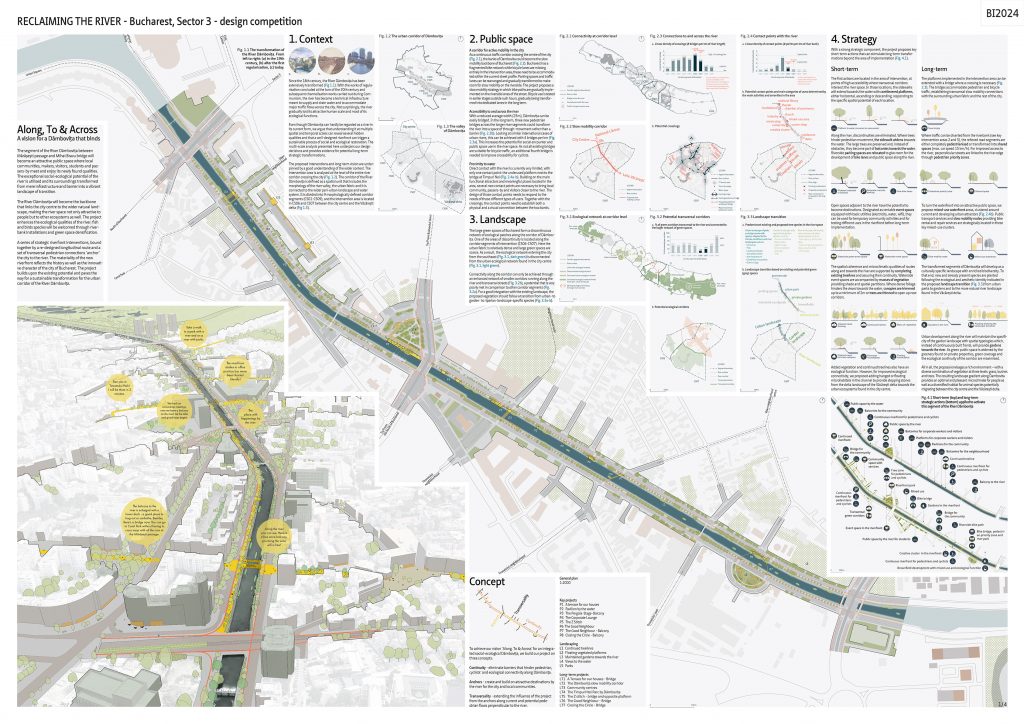
The segment of the River Dâmbovița between Mărășești passage and Mihai Bravu bridge will become an attractive public space where local communities, makers, visitors, students and passers-by meet and enjoy its newly found qualities. The exceptional social-ecological potentials of the river are utilised and its surroundings are transformed from a technical infrastructure and barrier into a vibrant landscape of transition.The River Dâmbovița will become the backbone that links the city centre to the wider natural landscape, making the river space not only attractive to people but to other ecosystems as well. The ecological qualities of the river will be enhanced, fish and birds species will be welcomed through riverbank installations and green space densification. Five strategic riverfront interventions, bound together by a re-designed longitudinal route and a set of enforced transversal pedestrian connections ‘anchor’ the city in the river. The materiality of the new riverfront reflects the history as well as the innovative character of the city of Bucharest. The project builds upon the existing potentials and paves the way for a sustainable transformation for the urban corridor of the River Dâmbovița.
1. CONTEXT
Since Bucharest started to grow as a city in the 18th century, the River Dâmbovița has been extensively transformed. With the works of regularisation concluded at the turn of the 20th century and subsequent channelisation works carried out during Communism, the river has become a technical infrastructure meant to supply and drain water and to accommodate major traffic flows across the city. Not surprisingly, the river gradually lost its attractive human scale and most of its ecological functions.Even though Dâmbovița can hardly be regarded as a river in its current form, we argue that understanding it at multiple spatial and temporal scales can reveal several hidden qualities and that a well-designed riverfront can trigger a sustainable process of social and ecological restoration. The multi-scale analysis presented here underpins our design decisions and provides evidence for potential long-term strategic transformations.The proposed interventions and long-term vision are underpinned by a good understanding of the wider context. The intervention area is analysed at the level of the entire river corridor crossing the city. The corridor of the River Dâmbovița is defined as a spatial unit that includes the morphology of the river valley, the urban fabric and it is connected to the wider peri-urban landscape and water system. To achieve our vision ‘Along, To & Across’ for an integrated social-ecological Dâmbovița, we build our project on three concepts:Continuity – eliminate barriers that hinder pedestrian, cyclists’ and ecological connectivity along Dâmbovița. Anchors – create attractive destinations by the river for the city and local communities. Transversality – extending the influence of the project from the anchors along current and potential pedestrian flows perpendicular to the river.
2. PUBLIC SPACE ANALYSIS
A corridor for active mobility in the city. As a continuous traffic corridor crossing the citycentre, the banks of Dâmbovița could become the slow mobility backbone of Bucharest. Bucharest has a fragmented bike network and bicycle lanes are missing entirely in the intervention area so these need to be accommodated in the current street profile. Parking spaces and the traffic lanes can be rearranged and gradually transformed to make room for slow mobility on the riverside. The project proposes a slow mobility strategy in which bike paths are gradually implemented on the riverside lanes of the street. Bicycle use is tested in earlier stages outside rush hours, gradually being transformed into dedicated lanes on the long term.
Accessibility to and across the river. With a reduced average width (25m), Dâmbovița can be easily bridged. On the long term, three new pedestrian bridges across the longer river segments could transform the river into a space of through-movement rather than a barrier. Looking at similar international cases of urban rivers, this can be achieved with 4 bridges per km. This increases the potential for social encounter and public space use in the river space. As not all existing bridges are suitable for bicycle traffic, an additional fourth bridge is needed to improve crossability for cyclists.
Proximity to water.Direct contact with the river is currently very limited, with only one contact point (the abandoned pontoons) next to the bridge at TimpuriNoi. Building on the main functional attractors and meaningful places located in the area, several new contact points are necessary to bring local community, passers-by and visitors closer to the river. The design of those contact points needs to respond to the needs of those different types of users. Together with the crossings, the contact points need to establish both a physical and a visual connection between the two banks.
3. LANDSCAPE ANALYSIS
The large green spaces of Bucharest form a discontinuous network of ecological patches along the corridor of Dâmbovița. One of the areas of discontinuity is located along the corridor segments of intervention (CS06-CS07). Here the urban fabric is relatively dense and large green spaces are scarce. As a result, the ecological network entering the city from the southeast is disconnected from the urban ecological network found in the city centre. Connectivity along the corridor can only be achieved through an enhanced network of smaller corridors running along the river and transversal streets, a potential that is very poorly met in comparison to other corridor segments. For a good integration with the existing landscape, the proposed vegetation should follow a transition from urban- to garden- to riparian-landscape-specific species.
4. STRATEGY
With a strong strategic component, the project proposes key short-term interventions that can stimulate long-term transformations beyond the area of implementation.Short-term. The first actions are located in the area of intervention, at points of high accessibility where transversal corridors intersect the river space. In those locations, the sidewalks are extended towards the water with cantilevered platforms, either horizontal, ascending or descending, responding to the specific spatial potentials of each location.Along the river, discontinuities are eliminated. Where trees hinder pedestrian movement, the sidewalk is widened towards the water. Where the sidewalk is occupied by large trees, they are preserved and, instead of obstacles, they become part of balconies towards the water. Riverside parking spaces are relocated to give room for the development of bike lanes and public space along the river.Open spaces adjacent to the river can be transformed into destinations. Designated as rentable event spaces equipped with basic utilities (electricity, water, wifi), they can be used for temporary community activities and for testing different uses in the riverfront before long-term implementation.The spatial coherence and microclimatic qualities of routes along and towards the river are supported by continuous treelines in which missing trees are added. Waterside event spaces are supported with masses of vegetation providing shade and spatial partitions. Where views towards the water are hindered by dense foliage, canopies are trimmed up to a minimum of 2m or trees are thinned to open up new corridors.Added vegetation and continued treelines also have an ecological function. However, for improved ecological connectivity, floating microhabitats are added in the channel to provide steppingstones from the delta landscape of the Văcărești delta towards the urban ecosystems found in the city centre.
Longterm. The platforms implemented in the intervention area can be extended with a bridge where a crossing is necessary. The bridges accommodate pedestrian and bicycle traffic, establishing transversal slow mobility connections with the surrounding urban fabric and the rest of the city.Where traffic can be diverted from the riverbank (see key intervention areas 2 and 5), the relieved road segments are either completely pedestrianised or transformed into shared spaces (max. car speed 15 km/h). For improved access to the river, perpendicular streets are linked to the river edge through pedestrian priority zones.To turn the waterfront into an attractive public space, mixed-use waterfront developments, clustered around the current meaningful places are proposed. Public transportation services and slow mobility nodes providing rental and repair services are strategically located in these key mixed-use clusters.The transformed segments of Dâmbovița will develop as a culturally specific landscape with enriched biodiversity. To that end, new and already present species are planted following the ecological and aesthetic identity indicated in the proposed landscape transition from urban parks to gardens and to the more natural river landscape found in the Văcărești delta.Urban development along the river will maintain the specificity of the garden landscape with spatial typologies which, instead of continuously built fronts, will provide gardens towards the river. As green public space is widened with the greenery found on private properties, green coverage and the ecological continuity of the corridor are maximised.All in all, a rich environment—with a diverse combination of vegetation at three levels: grass, bushes and trees—is formed. The resulting landscape gradient along Dambovita provides an optimal and pleasant microclimate for people as well as a diversified habitat for animal species potentially migrating between the city centre and the Văcărești delta.
5. KEY INTERVENTIONS AND DESIGN DETAILS
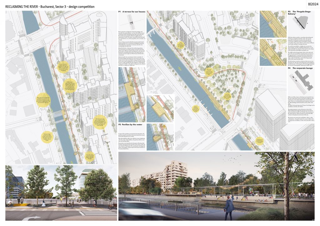
P1 – A terrace for our houses. There used to be a bridge here. Beyond nostalgia, and long after the systematization, one can still read the natural connection of the roads facing each other across the river. The city flowed towards the industrial neighbourhood, sloping down the hill. The slope was partly leveled and held by a wall behind a row of housing blocks, the tie of sides was severed.We turn history around and build connections both inland and towards the river: two terraces to bridge the retaining wall dividing the courtyards, two terraces onto the river, overlooking to the other side.Behind the blocks, in between the overbearing parking lots, the terraces act as both vertical connectors and small public spaces offering residents playgrounds, sport grounds, benches for socializing, bike and car self repair spots, all necessary excuses to get out of their house and tame their environment.Likewise, by the river, one terrace is level, a reminder of the former bridge and a basis for a new one to come, one terrace is lower and accessible by ramp so that the riverside and its views may be enjoyed by us all. The handrail towards the river is wider and tells the story of places, in both typical writing and in Braille. It also allows resting your arms, dreams and souls, or simply your coffee cup.
P2 – Pavilion by the water.Four pavilions accompany the intervention. The pavilions pinpoint secondary transversal streets that connect to the street along the river corridor. If the other platforms offer more collective ways of gathering with stairs, steps, large platforms, the pavilions offer a calmer and more intimate space. The pavilions are inspired by the first parks of Bucharest like Cișmigiu, being built at the end of the 19th century within the river corridor of Dâmbovița. The round kiosks, the allegorical statues, the pergolas, all give input to the formal resolution of the proposed pavilions.
P3 – The ‘Pergola-Stage-Balcony’. With three distinct modules—ascending, descending and reaching out straight towards the water—this structure transforms the sidewalk into a succession of different spaces and relations with the surrounding. These spaces attract a wide variety of different users living, working or crossing in the area.The southernmost platform, straight and covered with a green pergola, acts like a shaded meeting point. It is very easily accessible from all parts of the site, as it is the closest to the intersection and bridge crossing the river.The middle section brings people closer to the water and opens the view towards the concrete pontoon structure on the opposite bank. A visual and functional relationship is established between the banks: the pontoon becomes a stage, a place for festivities, a place that brings people closer to the water from both sides.The third section is raised as a balcony where one can see along the river. The stairs and seating open up the platforms towards the park. In the long term, the road segment behind the structure is downgraded, replacing car traffic with a public space that binds the park to the riverbank.
P4 – The corporate lounge. While most office clusters in Bucharest are located far from waterfronts, the few ones that are adjacent to the central river or the northern lakes fail to connect with the water. There is no continuity between the generic interiors of the office buildings and the beautiful scenery of the water edge.The office cluster growing around TimpuriNoi bridge has the possibility to activate such relation.The project proposes a series of terraces in front of the office buildings that bridge the gap between the abstract work environment and the river corridor; these terraces act like urban devices, which are meant to connect the office workers to the physical environment of the city. The terraces are meant to be used before, within, or after working hours – the perfect space for a cup of coffee in the morning, lunch at midday or a beer with sunset after a day’s work.
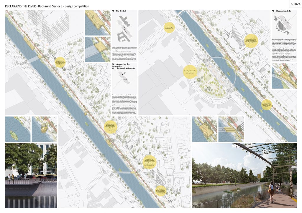
P5 – The Z Stitch. TimpuriNoi articulates public transportation routes, two bank sides, two facing poles – Cantemir and Titulescu universities vs emerging offices. A slow mobility connection between Tineretului neighbourhood and TimpuriNoi neighbourhood emerges in front of the university and east of the office buildings. The pedestrian bridge that forms defines a diagonal relation between university and offices. Long cantilever platforms create space for students and office workers but also for all the people crossing between the left and right banks of the river.
P6/P7 – The Good Neighbour. The corner shop lies in the centre edge of the historical urban fabric, being the only selling point along the riverbank for hundreds of meters. It grew naturally into a landmark, and its owner into a community leader: she knows all neighbours and involves them actively in demands for a public transportation line, stations and a pedestrian crossing bridge to get to the park and market on the other side. She talked to us eagerly.We listened and proposed firstly to extend the meeting and debating space of the community onto a platform on the river, twinning the corner shop. Holding up to 20 social distancing people, the platform acts as regular public space and is the viewing point towards the bridge that shall be build in the second phase – prolonging Călugăreni street by a diagonal bridge that leads to the bus station, market and park on the other side, re-sewing the neighbourhoods together.
P8 Closing the Circle.The southernmost strip of the studied area is passing through a process of radical future transformation. Residential and mixed function interventions substitute former industrial areas and unbuilt plots. In order to address the future urban intensity, we propose to reconnect the two banks with a bridge. Instead of remaking the bridge still existing there on the 1966 map, we propose a new urban knot. Using the semi-circular shape of the entrance to the former slaughterhouse, the two way round bridge closes the circle and creates a small cosy park with trees and water besides. Until the connection to the right bank of the river is completed, the round shaped balcony offers stunning views to and along the river. In addition, there is a lot to see! Birds from the near Văcărești delta often use the stepping-stones provided as boat/leaf shaped floating islets.
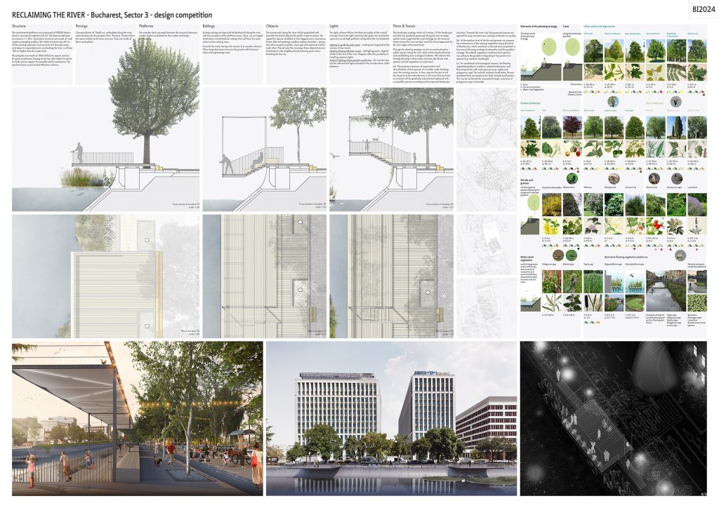
Structure.The cantilevered platforms are made of IPE200 beams fixed in concrete foundations(t.b.d.). The distance between two beams is 1.20m. Secondary structures are made of small simple rectangular profiles. The whole structure rises 42 cm off the existing sidewalk and connects to it through ramps and steps; its suspended part, overlooking the river, is at least 150cm higher than the water level. The pergolas are made of 100x100x5mm square sections for posts and beams, having on the top side cables for plants to climb and as support for possible textile membranes. The pavilions have round section 80x5mm columns.
Pavements. Concrete blocks of 15×60 cm, embedded along the river, make the base for the people’s flow. The trees’ frames follow the same module as the main structure. They are made of 8mm metal plates.
Platforms. The wooden deck mounted between the structural elements creates rhythm and detail for the smaller and larger interventions.
Railings. Existing railings are kept and refurbished all along the river, with the exception of the platform zones. Here, we envisaged metal plate vertical baluster railings that will have the same colour as the existing ones.
Towards the water the top rail consists of a wooden element 30cm large that hosts inclusive info panels with historical notes and sightseeing musts.
Objects. The promenade along the river will be populated with beautiful functional objects like public water fountains, designed for typical, disabled or four-legged users, lamp posts, kiosks, bike rail parkings, pedibus stations, benches – spaces that allow people to gather, meet, get informed and wait for each other. Placed near the crossings, these objects become landmarks for the neighbourhood and may grow into a branding for the city.
Light concept. The lights scheme follows the three principles of the overall concept. Ensure the light continuity along the river and at the same time avoid light pollution and protect the microhabitats. Thus, low and precise targeted lights define the anchor platforms of the project. The lighting system should not obstruct views towards the river, thus ensuring a visual transversality even at night starting from the first phase of the project. The proposal envisages three levels / types of lights: (1) Lighting to guide bicycle routes – small posts integrated at the corners of tree inserts; (2) Lighting along pedestrian routes – tall lighting posts, aligned similar to the rest of the river; Pergolas offer the possibility of installing catenary lights. (3) Ambient lighting where people would stop – the wooden top rail has referred led lights oriented to the wooden floor of the platforms.
Landscaping strategy. The landscape strategy works at 3 scales: (1) the landscape gradient proposed along the river at larger spatial scale, supported by a (2) strategy for the traversal streets across the river corridor, and (3) a local approach for the river edge at the street level. Through the planting strategy we create attractive public spaces along the river while enhancing biodiversity and establishing new habitats. We achieve this through planting in 3 strata: (a) trees, (b) shrubs and grasses and (c) vegetation at water level. (a) We propose a process of regeneration and diversification of tree species at a smaller scale, building upon the existing species. In time, species that put at risk the structure of the embankments or the ones that are hard to maintain will be gradually reduced and replaced with compatible species according to the proposed gradient. Towards the inner city, the proposed species are optimal for easy maintenance, cooling and better air quality. (b) At the medium level of shrubs and grasses we propose the maintenance of the existing vegetation along the bank of Dambovita, which would be continued and completed in key areas following ecological rationality and the gradient strategy. The added vegetation combines local species according to the gradient, integrating in key points new species (e.g. berberis thunbergii). (c) For aesthetical and ecological reasons, the floating vegetated platforms combine colored herbaceous and flowering shrubs with water grasses (e.g.: typha and polygomunspp). The colorful and perfumed herbs, flowers and plant fruits are attractive for both animals and humans. This can be achieved (for example) through insertions of polygomunspp or lavander.