


59 – CH2020 – Metapolis Architects BVBA, Atelier Mass, Ana Horhat
Autori principali: Atelier Mass, Ana Horhat, Metapolis Architects BVBA
Colaboratori arhitectură: Bogdan Simionescu, Alexandru Damian, Andrada Bolboacă, Ștefania Boca, Cătălin Pop, Erno Lenart, Roman Efros, Kevin Fenici
Asociere: Atelier Mass, SRL, Asociat 33,33%, Ana Horhat, Asociat 33,33%, Metapolis Architects, BVBA, Asociat 33,33%
ICON UNVEILED:
CETATUIA HILL
DESIGN COMPETITION
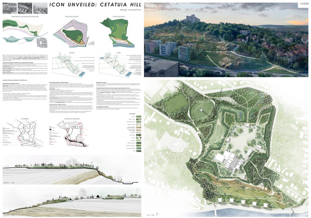
With its rocky face hanging 60m above the city, the Cetătuia Hill is the iconic Acropolis of Cluj-Napoca, playing a series of defining roles in the history and life of the city. Some of these roles are visible and acknowledged today – landmark, viewpoint, touristic and recreational destination, while others are less visible – the hill’s geological, ecological and historical/military nature. Given such rich layering, the logical redesign strategy is to reveal all the natures of the hill in their full complexity and interconnectedness.
LAND(SCAPE) FORMATION: ADDITION AND SUBSTRACTION PROCESSES
The proposed re-design toolbox builds upon the historical logic of the land(scape) formation processes: a sequence of additions and substractions, both natural and man-made.
Natural addition: sedimentation of geological strata, soil deposit, water infiltration and accumulation, vegetation development
Man-made addition: fortress land formation, plateau and slope colonization with buildings, retaining walls, roads, paths and stairs, cultivation of productive landscapes
Natural substraction: macro valley erosion, internal and surface rainwater erosion, natural caves system, landslides,
Man-made substraction: excavation for troglodyte dwellings in the rocky strata, excavation for ditches (military, drainage), excavation for construction of buildings, retaining walls, roads, paths and stairs
UNVEILING THE HIDDEN NATURE(S) OF THE CETĂȚUIA HILL
THE GEOLOGICAL NATURE OF THE HILL
Below the man-made landforms and the vegetal layer the site hosts a particularly rich and dynamic geoheritage. The main strata of the hill have formed originally through sedimentation during the Oligocen geological era, some 30 million years ago. The lower softer clay strata corresponds to a period when this area was the Paratethys Sea bed, while the more solid upper rock strata reveals the retreat of the sea but also the Grand Coupure extinction which left rich fossil base in the strata. Later on, the Somes river eroded these strata revealing the cuesta – the rocky outcrop on the upper banks of the valley.
This geodiversity is unveiled by making the strata more legible:
- the face of the rocky outcrop is cleared of bushes
- the top is cleared of the pathways, the walls and their foundations to make visible the solid strata; a new subtle pathway is realized in washed concrete made with selected aggregates recycled from the demolition of the existing walls.
- at the foot of the rock, a pathway follows the line separating the two geological layers, allowing the exploration of the strata and their fossils
THE HISTORIC/MILITARY NATURE OF THE HILL
As a venerable witness to the city’s history, the hill has many stories to tell.
Originally, the city is settled on its location not least due to the topographic feature of the hill along the river. With the construction of the Vauban fortification in the 18th century, the military potential of the hill is maximized. The construction of the parachute tower two centuries later still follows this military logic.
The citadel is unveiled by:
- reconstructing the few segments touched in the ‘70s
- levelling the microprotuberances on the slopes
- cleaning the slopes of low and medium vegetation in order to reveal a sharp military slope with neatly trimmed grass and the occasional trees that allow clear views under their high canopies
- defining a sober plateau inside the fortification, a shared space platform, able to host a variety of functions and
- defining the top: guard’s walk pathway on top of the fortification
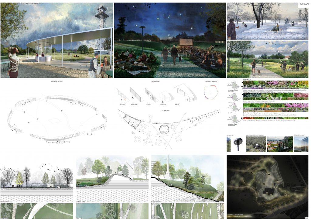
The parachute tower is staged by the development immediately outside its parcel of an activities device – a system of very light porticos – able of hosting several functions that serve the park areas around the tower. When the gates of the parcel are open this activities device creates a new centrality around the tower, linking the entire park.
The traces of the troglodyte caves become part of one of the thematic routes through the park.
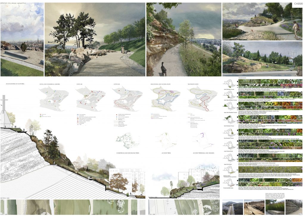
THE ECOLOGICAL NATURE OF THE HILL
The park is at the crossing point of two ecosystems: the Somes river corridor on the one hand and the forested ridge of the northern hills on the other hand. The traces of a structural biodiversity reveal a layered system, ranging form the lower wetlands, through the productive southern slopes, further through the upper meadows and the special rocky strata, reaching eventually the upper woodlands.
By reinforcing this latent landscape structure the hill becomes part of two metropolitan parks, connecting not only plant and animal life, but also the neighborhoods around it.
RESILIENCE BY DESIGN
Going one step further than fighting the (landslide) risk in a reactive and hyper engineered manner, the holistic approach of this project addresses the issue from the ground up: working with nature, rather than against it.
Understanding, protecting and enhancing natural/ geological phenomena
A look back at the local history of human interventions with impact on the stability of the hill revels that seasons with extreme storm surges correlate with landslides on the hill (1970, 1999 and 2010) and
in the context of climate change such events will become increasingly frequent.
A series of retention, drainage and stability measures are designed in complement to address this pressing issue.
- on the uppel level – the plateau – retention is key. New water bodies, but also a selection of appropriate vegetation hold the water and discharge it slower downhill, functioning as a crucial upstream buffer in case of storm-surge.
- at the foot the permeable rocky strata a large drainage collects the water that reaches nontheless this level, in order to channel it below the impervious clay strata, eliminating thus the risk of topsoil erosion
- furthermore, this topsoil on the impervious strata is planted with water retaining plans
- at the foot of the hill, rain gardens are put in place to buffer one last time the rainwater before discharging the eventual leftover quantity into the river
The park thus becomes an embedded component of the hydrological system of the river Someş
AN INTEGRATED ECOSYSTEM
The unveiled and reinforced natures of the landscape become one integrated ecosystem of symbiotic logics: the true nature of the Cetătuia Hill.