


51 – XK0153 – URBAN SYNAPSE SRL
Autori principali: urb. Damian Alexandru Ioan
Coautori: urb. Damian Laura
Colaboratori arhitectură: arh. Bucur Tiberiu Vlad, arh. Bucur Mădălina Smaranda, stud. arh. Nagy Krisztina
Colaboratori specialități: ing. Theiss Maria
CONCEPT
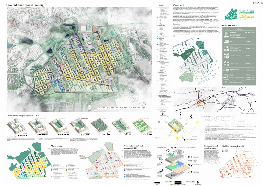
The urban layout chosen by our team is based on the grid, an urban development system that has been tested throughout the ages and has proved to be functional over and over again. It is adaptable, expandable and ready to grow and mature, along with the evolution of lifestyles, technology, education, transportation and leisure activities. Given the destructured urban surroundings of the study area and the disorganized way the city has evolved in recent times, the need for urban structure and control in new developments has become a necessity.
The orientation of the proposed built environment, tilted to an angle of 25 degrees, can also be seen in the historical center of the city and thus represents a tip of the hat to the old urban pattern of Cluj-Napoca, creating a new urban layout that has its roots in the urban city heritage.
Furthermore, this orientation was generated by the presence of NW-SE dominant winds in the area. Combined with the large green areas located north of the study area, dominant winds will act as a cooler to the entire district during the hot season, bringing cool air from the green areas, and the proposed linear green “blocks” that intertwine with the built environment will act as distributors of the cool, fresh air into the new district.
The proposal is conceived so that the surrounding agricultural landscape will intertwine with the built space, making a smooth transition from city to farmland, through the help of some experimental, local farming areas, proposed as a buffer area.
The animate natural layers of the whole masterplan is intertwined with the structured built space, through vast green spaces, plantations, ground and landscape modeling and water amenities, that all have an organic design. Combine that with a vibrant local community that loves where they live and work, and the result is a successful, functional, active and attractive district.
MAJOR ZONING
The mixed use that is promoted within the project supports a self sustainable functional urban area, with little need of visiting the crowded city centre and promotes a walkable lifestyle, supporting functions like education, culture, research and development, offices, retail, general / personal services, health, experimental and agri-urban uses, all mixed within residential buildings, which occupy more than 50% of the built surface within the area.
“THE WALK OF LIFE” AND COMMUNITY LIFE
The “Walk of Life” , an exclusive pedestrian and bike path, is a concept which, overlaid with all the green areas proposed within the masterplan, creates a continuous loop of leisure with natural amenities, which connects the entire area with itself and links it to the rest of the city’s leisure areas. This special path, combined with the network of bike paths integrated within the local street system, offers easy accessibility to any location with a social component (education, culture, public spaces etc.), and to the community and mobility centers scattered across the masterplan.
COMMUNITY AND MOBILITY CENTER
This building type represents the core of social life and mobility within the project. It is the place where people can easily switch from using their cars to using a more eco-friendly type of transport, like bikes, kick scooters or public buses. While performing this mobility switch, they can also repair their bike, charge their electric car, participate in a community meeting taking place, go grocery shopping, pay their bills, take their clothes to the dry cleaner or go to the dentist, because those are the types of uses promoted within these buildings.
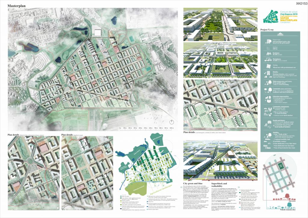
CITY GREEN AND BLUE
The surrounding green spaces from the north (Băile Someșeni, Între Lacuri, Centrul sportiv Gheorgheni) have been extended into the project as green strips of major parks, that act as a cooling agent of the whole project, the river Becaș representing their backbone. All the public and social uses have direct and easy access to green spaces.
The project also takes into account the vicinity of the orchards and agricultural landscape to the south, and proposes a smooth transition from city to farmland, through the help of some experimental urban gardens and local farming areas, proposed as a buffer.
The existing and proposed waterways and lakes, together with the green spaces, provide a local, safe and non destructive flood protection system.
The natural layer of the whole masterplan is intertwined with the built space, through vast green “blocks”, plantations, ground and landscape modeling, and water amenities, that all have an organic design.
TRAFFIC LAYOUT
The innovative mobility concept, with mega blocks (3×3 blocks), one way streets, and walkable neighborhoods, along with the promotion of mixed use, will lead to the development of a modern, energy efficient and lively urban area.
The major street system is represented by the existing roads (red), proposed as 4-lane two-way streets.
Also, our team proposed that the city bypass (brown) go underground, because keeping it above would create a major barrier between the city and the new development, and would isolate the whole Sopor district. Putting it underground will also facilitate direct access to the underground parking within the office building areas.
The local traffic layout is developed using the grid system, and is composed exclusively of one way streets.
The main one way streets (orange) have 2 lanes and go in loops of 3×3 urban blocks, resulting in intersections without conflict.
Car access on the one-way, one-lane local alleys (blue), is possible only for residents and local businesses.
PUBLIC TRANSPORT
Public transport within the area is going to be connected to the city transport, through a city bus, that will have a route on the major 4-lane street system and will use the existing terminal situated at the east of the site.
The project also proposes a local electric-bus route, that will connect all the main focus points of the district, going in a one-way loop throughout the day. This local bus line will have stops at most of the community and mobility centers and will be a sustainable alternative to personal cars. Also, the connection to the community centers will mean an easier switch between bike, bus and car, and will encourage people to use alternate means of transportation within the area.
Another important connection will be the one with the regional railway, where we propose a major station, connecting train, future metro, bus, bike and pedestrian transit.
SUPERBLOCK
The concept of the superblock (3×3 urban blocks) that we proposed means that a superblock is surrounded by main streets for general traffic, but within the superblock, car access is restricted to one-way local alleys, that only allow resident and local business access. These alleyways do not intersect with each other, leaving pedestrian space between them through which people can walk without being disturbed by cars, and without them disturbing car traffic.
Therefore, one can get from point A to point B on foot (700 m walk) without crossing any streets.
This concept gives the proposed masterplan the essential characteristic that is walkability.
Furthermore, each superblock contains at least one green block, and from any given location within the project, residents can reach a park within 5 minutes of walking (300 m).
OCCUPYING THE GRID
The SOPOR masterplan is built upon the idea of a new district that creates a functional urban connection between the existing city and the surrounding landscape.
The proposal envisions a multitude land use types and densities, satisfying the various types of owners and investors. From high to medium density, the built volumes create a gradual connection between the inner, dense core, and the outer agricultural environment at the southern project limits.
SUSTAINABILITY
is promoted within the new district through multiple factors, like
- imposing mixed use and avoiding single use buildings or areas
- evenly distributing social, public and educational functions throughout the district
- Avoiding high-rise buildings, but also avoiding urban sprawl proposals
- using community and mobility centers to respond to community needs and to facilitate mobility switches
- offering infrastructure for alternative means of transport
- using dominant winds to cool down the district
- designing an integrated system of public parks, green spaces and squares, and buildings with inner green courtyards, all interconnected with pedestrian and bike lanes, and with public transport routes
- using green spaces as floodable areas in case of extreme weather events, and designing artificial waterways for the excess water during heavy rainfall
- promoting walking, cycling, kick scooter-ing, electric bus use
- imposing that all the terraced buildings must be equipped with solar panels for the production of electricity, for local use or for powering the main grid supply.
ENERGY EFFICIENCY
- Given that legislation imposes that all buildings made in Romania after the year 2020 will have to be nZEB (near Zero Energy Buildings), the project proposes the integration of alternative energy production within each building.
- For example, Cluj is situated in an important solar energetic flux zone (1600kWh/mp/year).
- Another way of improving energy efficiency is by respecting a WWR (Window-to-wall ratio) of a maximum of 50%.
- Furthermore, the proposed urban pattern, with a 25 degree tilt, does not generate fully north or south facades and means that all facades of buildings get direct sunlight in certain moments of the day.
- Moreso, interior courtyards aid in ventilation and help preserve optimal temperatures and interior lighting.
PROJECT PHASING
The municipality must create a basic framework for implementation, within which the urban market may function, containing three major categories:
Land use regulations
- Primary infrastructure regulation
- Local fees and taxes
- All of these categories can be further transformed into sets of measures and tools of governance, that can be used in the process of implementation of the masterplan.
Financial
- Current market-based determination of land prices
- Final investment determination of land prices
- Imposed city/district tax for funding park and open space projects
- The city must develop a land acquisition/land swap program for landowners in the area
- Inform interested landowners and developers on possible transfer of development rights
Topography
- Clear topographical boundary of the implementation area (phase 1)
- Clear topographical boundary of different phasing areas (phase 1, then updated within every phase)
- Clear topographical plan for street system land designation (phase 1)
- Clear topographical plan for public and active (farming) / passive (parks) green space land designation
Urban regulations
- Clear regulations as to which land allows buildings and which land does not (phase 1)
- Imposed floor area percentages for each dominant use and its complementary uses, in order to promote mixed use (phase 1)
- Impose clear locations for community centers, educational, cultural and social developments (phase 1, then updated within every phase)
- Floor area ratio (FAR / C.U.T.) that allows medium to high density
Infrastructure
- Main city street modernisation (phase 1)
- Underground city bypass (phase 1)
- Development and extension plan for public infrastructure systems (updated within every phase)
- Development and extension plan for public mass transportation systems, including station locations (updated within every phase)
- Development of multi-modal transport hub that integrates regional and local rail (phase 3)
- Development of “Walk of life” – the pedestrian and bike dedicated path (phase 3)
- Development plan for bike paths integrated within the street profiles (phase 1, then updated within every phase)
- Implementation of bike and kick scooter sharing system, integrated with rental, storage and service facilities within each community and mobility center (phase 1, then updated with the construction of each new mobility center)
Community
- Create a special Agency that will offer financial and planning consultancy for local landowners, landowner associations or interested investors (phase 1, 2)
- Organize community meetings for informing the interested population on the development and implementation of the masterplan (phase 1, then updated within every phase)
- Agency headquarters must be located within the first community center that will be built within the area (phase 2)
- Agency must present mock-up (3d model) and brochure with masterplan to any interested landowner/resident/investor
- Organize a produce/fresh food fair that will take place within the proposed local farming area (phase 2)
Environment
- Impose the non-aedificandi regulation on all green areas within the project (all phases)
- Impose treelines on both sides of all streets (all phases, when new streets develop)
- Create the artificial waterway system, that alongside green spaces and local farming plots, functions as a hillside water collector and flood protection mechanism
- Impose that all new buildings within the area be nZEB (near Zero Energy Buildings)
- Impose solar panel use on roof for all new buildings
- Impose a maximum of 50% WWR (window-to-wall) ratio for all new buildings
For each phase, the local administration must go through all these measures and select the ones that apply to the phase in question, prioritising all the measures that refer to regulations concerning redistribution of land on the new plot system, accessibility, mobility, land designation for infrastructure, educational, cultural and social centers, and last but not least, land designation for green and public space. Also, before giving building permits within the area designated for each phase, the street and technical infrastructure must first be implemented.