


103 – PP1001 – PELINU PROJECTS SRL – BEROS ABDUL ARHITECȚI ASOCIAȚI SRL
Autori principali: PELINU PROJECTS SRL (Laura Cristea, Raphael Zuber) – BEROS ABDUL ARHITECTI ASOCIATI SRL (Christian Beros)
Coautor: Maurus Schifferli Landschaftsarchitekt AG
Colaboratori arhitectură: Edyta Filipczak, Michał Starzyński, Erich Babă, Ana Brebeanu, Mădălina Dobre, Bianca Dumitru, Ana-Maria Marțiș, Raluca Mihăilă, Andreea Stah, Adi Bratu (visualisations)
LIVING WATERS – ECOLOGICAL RESTORATION OF THE LAKE NECKLACE
Our starting point for this proposal is the water, and specifically the urban waters, as in the case of the “lakes necklace” in Bucharest.
This series of lakes that runs from the northwest to the southeast of the city represents not only an opportunity for the development of a pedestrian promenade for local users, but also the opportunity to build the city from the water, considering it a primordial and essential element of human life. It offers the chance to establish new linkages between disconnected urban fabrics and to highlight the importance of taking an ecological perspective when considering the cities of the future, especially under the constant threat of ongoing global warming.
The premise we established for this proposal is based on the need to focus on water as a limited resource. Without water, there is no border, and thus any future development opportunity falls into a void and loses all meaning.
Today, the level of knowledge about urban waters in Bucharest is both minimal and uncertain. There are not enough scientific studies to inform us about the water quality, its flow control or about its management throughout the city, and we certainly know much less about whether we will be able to rely on this resource in the next 25 or 50 years. The majority of information is spread across various institutions, public and private organizations, with little to no coordination and the detailed scientific studies are minimal or sectorial, in terms of hydrological engineering as well as about urban ecology and biodiversity.
With this question in mind, we decided to consider the urban border of the lakes from the perspective of the water itself and the need to protect it, and maintain it as a basic resource for the local ecology. From there, we devised three complementary strategies:
- Cleaning and preserving
First, how to establish systems for filtering, and purifying the water, with the goal of obtaining water suitable for use as a leisure space and also as a basis for complex ecological systems that will help maintain and extend local biodiversity. We propose a series of systems to address the issue. Floating filtration islands working with local species to purify naturally the water. Enclosed natural areas, hoping to renaturalise full patches of the existing wetlands and save them from future human intervention. Ancient water farming techniques as the Chinampas can provide different ecosystem services, particularly greenhouse gas sequestration and biodiversity diversification, as well as a high recreational potential. - Leisure activities
Second, the border itself, the meeting point between water and land, where the largest number of spaces, functions, and activities can be concentrated, seeking to activate the border and to build urban attractors that highlight an urban resource that the city has turned its back on. An exploratory path is proposed, having different stations with infrastructure for new leisure functions. This strategy aims to engage the community and to improve the local social and economic conditions of some of the neighborhoods which are segregated from the city’s activities. - Cooling and CO2 capturing
Lastly, the nearby land, the green space adjacent to the “lakes necklace,” which needs to be enhanced, structured, and densified as a green-blue corridor throughout Bucharest. This corridor can have a significant effect in cooling the city and capturing CO2. The adjacent green areas are key to establish a more comprehensive approach to the city, where we need to consider green and blue resources not as a thin border line, but more as corridors and large patches of biodiversity which can be developed through renaturalization strategies, increasing biodiversity and protecting the local ecology as a whole.
Following this definition, the proposal aims to give water a key role in the future development of Bucharest, reviving historical ideas from the interwar period when these lakes were envisioned as a space for leisure, navigation, and improving the quality of life of the inhabitants. Unfortunately, in the last 50 years, this vision has been abandoned.
The ideas presented here are a viewpoint from landscape architecture and from the development of cities through an urban ecology perspective. These ideas are outlined for what we believe should be a long-term effort, ideas that require technical work from engineering architecture and especially from ecology studies, involving much more complex analyses beyond the scope of this competition. Our actual design proposal has a surgical character. With few but highly precise interventions at neuralgic points, we aim to achieve the maximum effect with minimal use of resources.
However, we believe that the bigger concepts need to be discussed, confronted, and applied in order to think about how Bucharest can project itself into a complex future in the face of global warming, climate change, and the increasing scarcity of the resource in question – water.
LOT 1 – Premiul I
“Propunerea pentru Lotul 1 cuprinde o zonă naturală de îmbăiere, care, privită de pe pod, se bucură de un caracter scenografic ce asigură o poartă de intrare pentru întreg proiectul. Soluția oferă o bună conectivitate între Parcul Verdi și această zonă de îmbăiere, printr-o nouă alee a arborilor ornamentali cu flori. În rest, parcul se bucură de o flexibilitate în amenajare care se poate definitiva în colaborare cu autoritatea contractantă. Juriul a apreciat că această primă amenajare a parcului s-ar putea realiza cu ușurință încă din prima fază de implementare a proiectului.
Soluția pentru Lotul 1 utilizează strategii bazate pe natură pentru a asigura filtrarea apei concomitent cu îmbunătățirea ambianței și a caracterului peisagistic al zonei. În acest sens se propun o serie de paliere de vegetație ce se constituie într-un peisaj intermediar între suprafața apei și maluri. Pentru acest Lot, peisajul propus are un caracter mai urban, diferitele intervenții reușind să fie lecturate ca și componente ale unui peisaj unitar.” – aprecierea Juriului
TEI AND PLUMBUITA LAKES – Regenerative peninsulas
The first section of the lake sequence begins immediately after Herăstrău and Floreasca lakes, which are perhaps the best maintained in terms of volume, flow, and quality of the water, as they are some of the most established public spaces in the city. This section features a strong urban component, yet its borders are more deteriorated, and in some areas abandoned, lacking the necessary functions to activate their use, or to invite users to appreciate its potential. The water, being regulated to supply the northern lakes, faces issues such as stagnation, algae growth, and accumulation of debris, which needs to be treated. This stage serves as an invitation to consider a regenerative approach, where ecological restoration can be established through interventions both in the water and along its edges.
The ecological objective is to establish filtration “peninsulas” and “islands”—interventions using floating devices along the lake’s edge, planted with specific species to facilitate natural water purification. These features are intended to serve as attractors for the activities and events described below.
- The Start – Natural Urban Pool
The most central and urbanized part of the lake necklace begins with a distinctive lagoon-like space located just after the Floreasca Dam. Nestled between the busy streets of Barbu Văcărescu and Calea Floreasca, this lagoon, despite its prime location in a wealthy north-central neighborhood, currently appears neglected, rarely accessed, and underutilized. The water quality is poor, characterized by algae buildups, and the inclined concrete edge is unclean, uninviting, and disruptive.
The proposal aims to transform this lagoon into a naturally cleansed open lake swimming pool. By incorporating floating filtration systems and border wetlands, the area would be revitalized into a unique urban leisure spot, serving as a key starting point for a broader ecological lake restoration initiative. In the long term, the abandoned sports facility to the north could be repurposed into a beach-sport area with open and covered sports fields.
The natural pool would be encircled by a spacious wooden deck, functioning as a sunbathing area, with piers extending into the water beyond the filtration zone. The promenade on land would be lined with Albizia Julibrissin trees, enhancing its significance and connecting it to the adjacent Verdi Park. - Verdi Park – Blooming Path Leading to the Lakes
The park’s current layout is largely preserved. The grid of trees is to be densified, with new plantings replacing unhealthy trees as needed to restore a robust ecosystem.
The existing path, flanked by tall wild chestnut trees, will be retained but reshaped into a slightly curved ‘banana’ profile to facilitate inclusive access from the surrounding elevated streets. A new, gently curved perpendicular path will lead towards the lagoon, its importance accentuated by lining it with the same Albizia trees that border the natural pool.
This path will culminate in a park entrance plaza, partially covered by a fragmented roof designed to integrate with the existing trees. The plaza will offer minimal facilities, including a kiosk, toilet, benches, and sheltered spaces for year-round use. The area will be further enriched by the addition of shrubs and bushes that retain their color during the winter. - Tei South: Sports and Clubs Complex
The existing promenade is to be primarily preserved and restored where necessary, with the addition of new tree alignments and densely planted wider pockets. The lake’s edge will be visually extended with a series of filtration peninsulas and wetlands, reconnecting the sports park to the lake’s ecosystem.
In the long term, the circulation path will be cleared of the clustered bars, clubs, and their annexes. Designated areas for restaurants or clubs may remain at intervals, subject to strict regulations regarding their relationship to the water, with opportunities for terraces that open towards the lake.
Given the strong tradition of water leisure and bathing during the communist era, the proposal includes the reuse of the old, abandoned pools as artificial outdoor pools. These could be managed by the city or leased to local clubs. - Tei North: New Neighborhood
Currently under development, the proposal suggests the creation of an urban path well-connected to existing streets, with a long-term vision of linking the new neighborhood to the city and Tei South via the water, potentially through pedestrian piers or a cable ferry. The urban promenade will vary in width and form loops according to the anticipated future density, but will consistently feature new vegetation and piers with distinctive characters that serve as landmarks and can be used for various activities. - Plumbuita Lake: The Start of a Larger Natural Area
The natural area is to be preserved in its current state, with a minimal loop path constructed from stabilized gravel. The right shore will remain closed to the public, allowing nature to flourish. Nesting areas will be created in the water, along with minimal filtration wetland interventions to improve water quality and maintain a healthy ecosystem. A viewing platform on the water’s edge will be the sole resting point. The paths will connect further to Tei North and Plumbuita via a floating path under the bridge, enhancing the connectivity of the entire area.
Moving towards Plumbuita North, the long-term vision is to enhance the natural character of the northern shore, creating a green corridor that extends to the Valea Saulei natural area.
LOT 2 – PREMIUL I
“ Echipa prezintă mai multe propuneri poetice de transformare a peisajului, care nu numai că îmbunătățesc calitatea apei și a habitatului, dar sporesc și experiența publicului în natură. Echipa are o abordare sugestivă și de tip „land art”, folosește idei relativ simple, ușor de înțeles, care sunt deja experimentate și implementabile. Autorii fac referire la utilizarea istorică a „Chinampas” sau a grădinilor agricole flotante ca o modalitate de utilizare a articulării Văii Saulei în acest lot. Propunerea va oferi un experiment interesant privind producția alimentară urbană plutitoare, și ar crea și zone de cuibărit pentru păsări. Zonele de stufăriș propuse pot contribui la depoluarea apei și ar putea fi explorate chiar din apă, eventual cu caiacul.
Echipa a recurs la o abordare tehnică și funcțională pentru crearea unui peisaj deosebit, care are și o componentă educațională. Propunerea turnului de observație va permite vizitatorilor să privească de la înălțime Valea Saulei pentru a admira elementele peisajului. Turnul în sine are un gabarit care se potrivește cu cel al traseului prin natură și al estuarului și deveni punct de reper.
De asemenea, echipa sugerează folosirea elementelor existente și crearea de forme geometrice simple cu acestea. Activitățile antropice pe care le imaginează în natură contrastează cu formele organice ale habitatelor naturale sau cu soluția de împădurire propusă. Echipa s-a gândit la structura de vegetație înaltă, medie și joasă și sugerează o intervenție simplă, dar poetică, cu flori sălbatice, pentru o pajiște tăiată între arbori. Poiana din parc, cu oglinda sa interactivă de apă adresată copiilor, este în spiritul inserțiilor geometrice simple din cadrul unei structuri organice la care echipa apelează în conturarea soluțiilor.” – aprecierea Juriului.
PLUMBUITA AND VALEA SAULEI LAKES – Constructed wetlands
The second section of lakes takes on the characteristics of wetlands, where efforts to restore and regenerate the aquatic environment are intensified through the use of ancient techniques such as Chinampas. These aquatic agricultural units not only enable the effective local production of fruits and vegetables but also contribute to the filtration, purification, and enrichment of water biodiversity. New floating islands and water jets are proposed in front of Plumbuita, aiming to enhance water movement and natural filtration, thereby creating new public spaces for the city, as described below.
- Natural Areas
The Plumbuita natural area extends with a dual connection under Petricani Street toward the Plumbuita area. One arm of this connection leads to the wilder landscape on the Plumbuita North shore, currently unstructured and unused. The proposal suggests densifying the existing vegetation and creating a non-invasive exploratory path, thereby establishing a green corridor towards the Valea Saulei natural area. - Water Farming: Chinampas
In the long term, the abandoned and dried-out fish ponds between Plumbuita Lake and the A3 highway present an opportunity for revitalization through the ancient Aztec water farming technique, Chinampas. This system of alternating water channels and planting islands offers multiple benefits, including water filtration and land enrichment for farming. The area could serve as a tree nursery for the entire lake necklace, a botanical water garden with unique landscaping features, and a tourist attraction. Its strategic position between Valea Saulei and Plumbuita Lake positions it as a potential central cleaning station in a future water management strategy, where interconnected lakes could support each other. - Domestic Area: Tei Toboc
For the promenade in the low-rise, high-density neighborhood of Tei Toboc, the proposal recommends minimal intervention, retaining the existing street as a shared space and reducing vehicle speeds. The unstructured pockets along the street could be transformed into a large orchard, planted with fruit trees and berry bushes, creating a social and playful space for the neighborhood. This orchard would reflect the intimate and domestic atmosphere typical of Romanian village life. - The Magic Island with Flower Fields
The centrally located island, with its unique and privileged position, is envisioned as an elegant and special gathering place where residents from both adjacent peninsulas can meet, akin to an outdoor common “guest room.” A large, colorful flower field, hidden by densely planted borders, would be revealed only when crossing from one side to the other. This flower field would also support a rich ecosystem for bees and other insects. - Plumbuita Monastery Island and Objective Park
The existing promenade will be preserved with improvements to the shortcut connecting the Magic Island to Plumbuita II Park. Vegetation throughout the area will be densified using a grid system.
Internal streets connecting both shores will be planted with fruit trees, continuing the domestic character of Tei Toboc. Park connections will be maintained and extended, leading from an entrance area with a roof and kiosk to a circular shallow children’s pool and a main round path lined with fruit trees. The pond will provide a safe space for children to interact with water and learn about water plants, promoting ecological awareness. The existing free-style paths and circular themes in Plumbuita parks will be preserved and enhanced. - New Developments
New developments in Plumbuita North, on the eastern shore, will be connected by an urban-like promenade, featuring a newly planted wide stripe of trees providing large canopies. The supermarket, as a neighborhood attractor, will be linked to an exploratory and fishing pier, potentially with a boat or cable ferry connection to the Monastery Island. Additionally, the proposal includes targeted renaturation of the inclined concrete surface, with holes allowing for filtration and shore stabilization plants to establish direct contact with the water while maintaining a firm border.
LOT 3 – Premiul I
“ Propunerea include o plajă publică – o idee interesantă care trebuie studiată pentru a se asigura că nu afectează cursul de apă. Amplasarea plajei în apropierea parcului Cosmos, a altor activități sportive și de agrement este una potrivită. Juriul apreciază faptul că propunerea nu modifică în mod semnificativ Parcul Cosmos, acesta fiind relativ nou construit, ceea ce reprezintă o abordare viabilă din punct de vedere economic. Sunt propuse structuri pavilionare simple, inclusiv o belvedere spre terenurile de sport existente și lacuri. Proiectul include mai multe poduri cu un design simplu și elegant. Elementele arhitecturale sunt simple și bine concepute și completează propunerile peisagistice.” – aprecierea Juriului
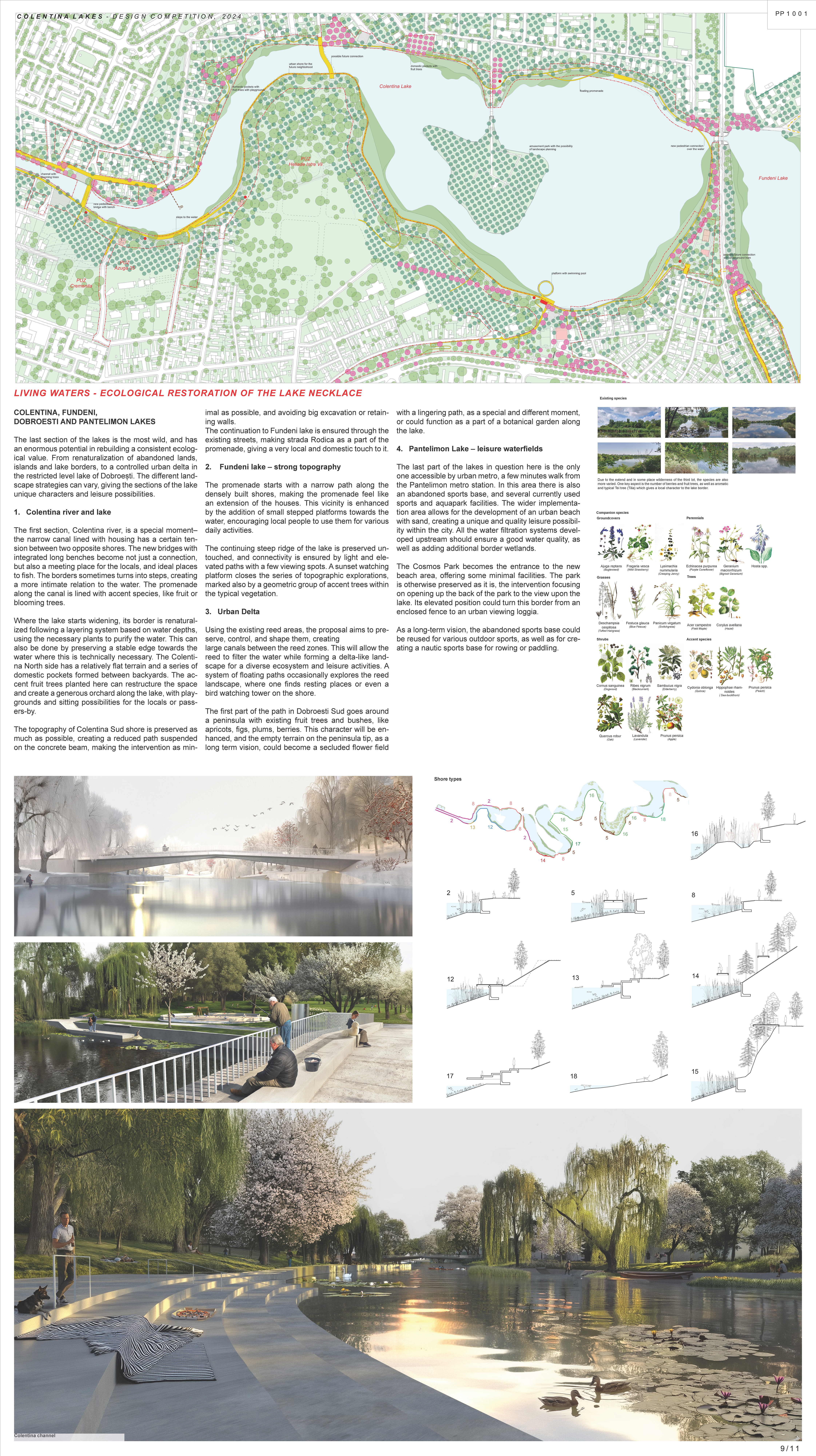
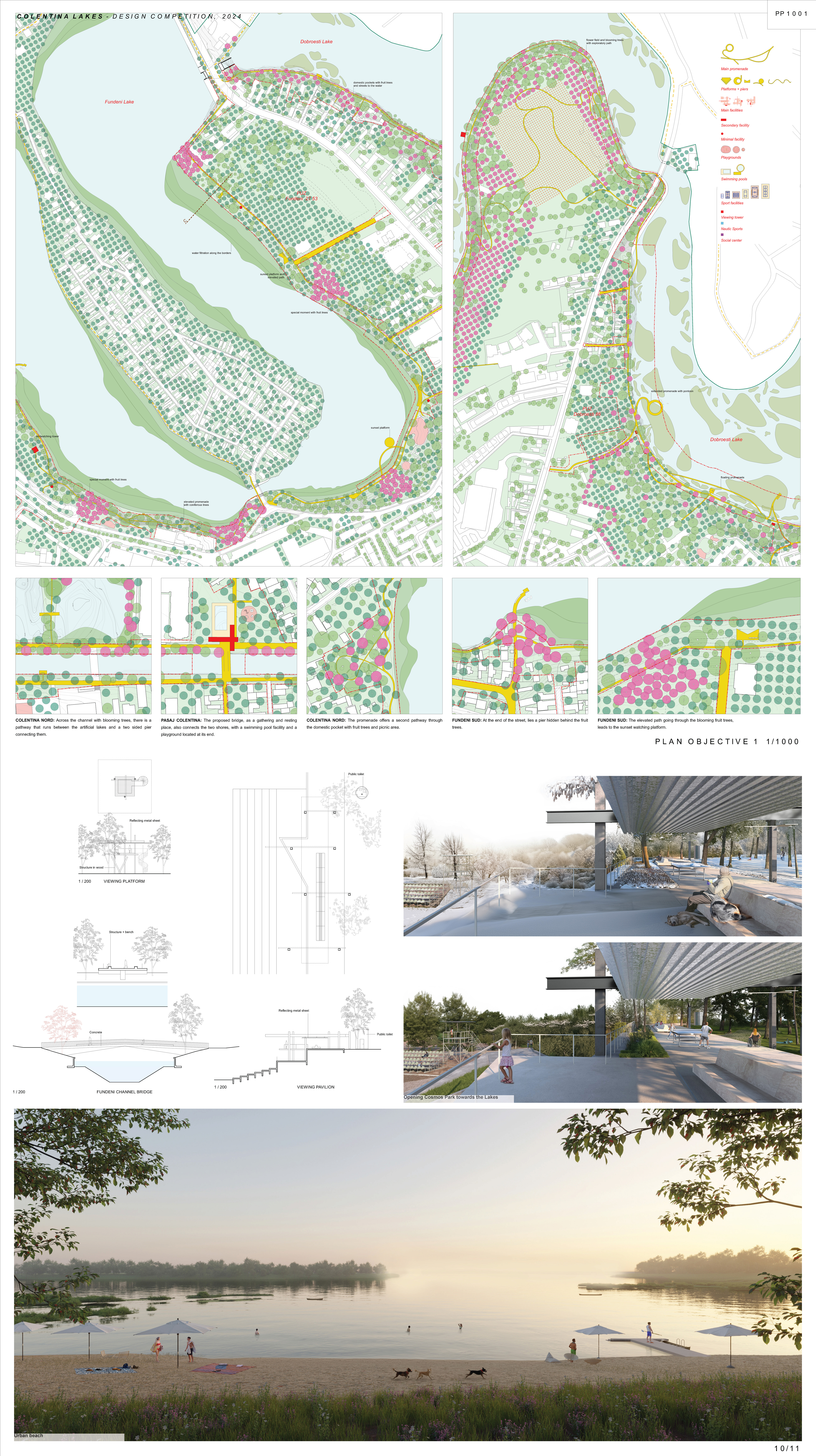
COLENTINA, FUNDENI, DOBROESTI AND PANTELIMON LAKES
The last section of the lakes is the most wild, and has an enormous potential in rebuilding a consistent ecological value. From renaturalization of abandoned lands, islands and lake borders, to a controlled urban delta in the restricted level lake of Dobroești. The different landscape strategies can vary, giving the sections of the lake unique characters and leisure possibilities.
- Colentina river and lake
The first section, Colentina river, is a special moment– the narrow canal lined with housing has a certain tension between two opposite shores. The new bridges with integrated long benches become not just a connection, but also a meeting place for the locals, and ideal places to fish. The borders sometimes turns into steps, creating a more intimate relation to the water. The promenade along the canal is lined with accent species, like fruit or blooming trees.
Where the lake starts widening, its border is renaturalized following a layering system based on water depths, using the necessary plants to purify the water. This can also be done by preserving a stable edge towards the water where this is technically necessary. The Colentina North side has a relatively flat terrain and a series of domestic pockets formed between backyards. The accent fruit trees planted here can restructure the space and create a generous orchard along the lake, with playgrounds and sitting possibilities for the locals or passers-by.
The topography of Colentina Sud shore is preserved as much as possible, creating a reduced path suspended on the concrete beam, making the intervention as minimal as possible, and avoiding big excavation or retaining walls.
The continuation to Fundeni lake is ensured through the existing streets, making strada Rodica as a part of the promenade, giving a very local and domestic touch to it. - Fundeni lake – strong topography
The promenade starts with a narrow path along the densely built shores, making the promenade feel like an extension of the houses. This vicinity is enhanced by the addition of small stepped platforms towards the water, encouraging local people to use them for various daily activities.
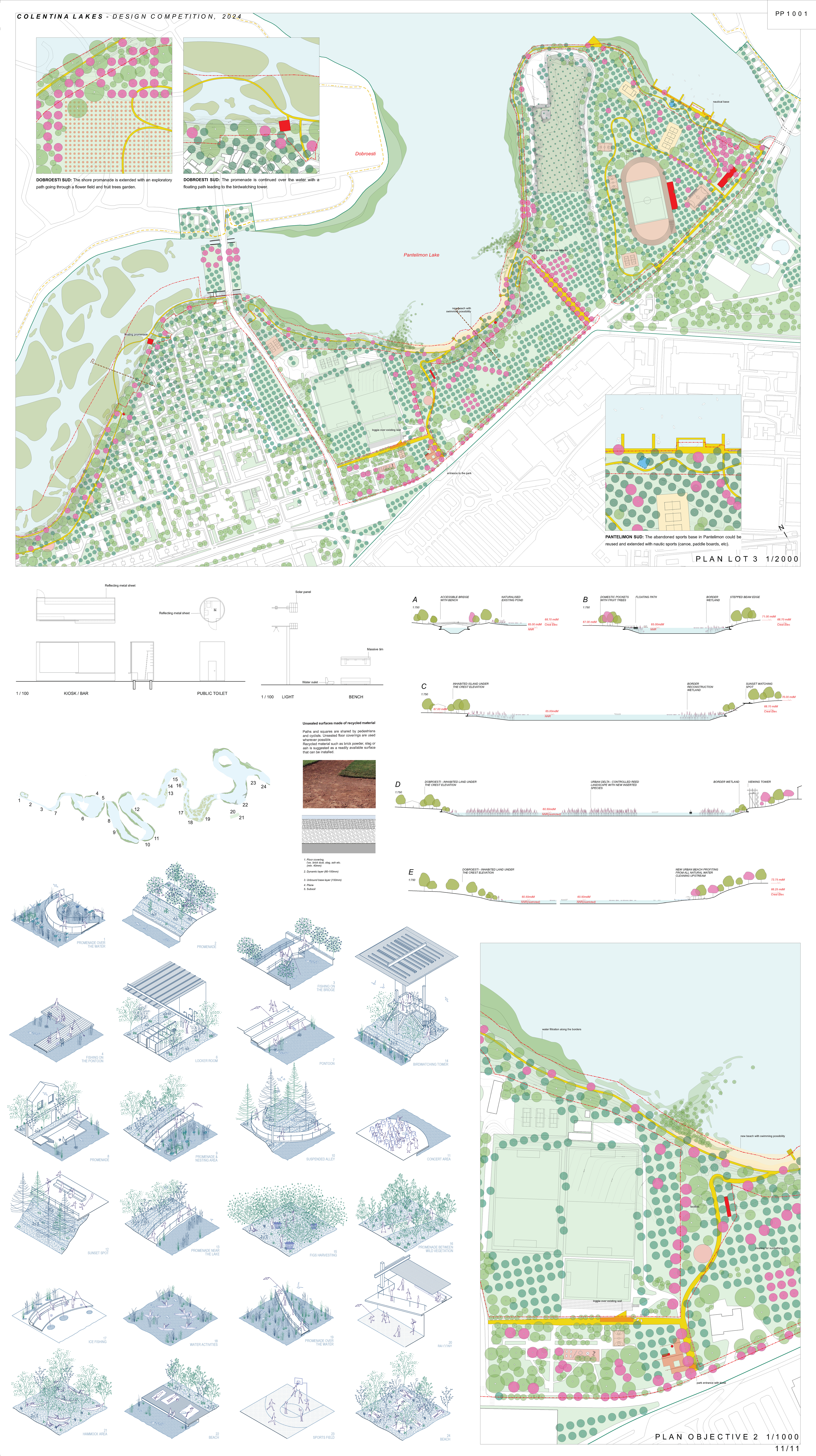
The continuing steep ridge of the lake is preserved untouched, and connectivity is ensured by light and elevated paths with a few viewing spots. A sunset watching platform closes the series of topographic explorations, marked also by a geometric group of accent trees within the typical vegetation. - Urban Delta
Using the existing reed areas, the proposal aims to preserve, control, and shape them, creating large canals between the reed zones. This will allow the reed to filter the water while forming a delta-like landscape for a diverse ecosystem and leisure activities. A system of floating paths occasionally explores the reed landscape, where one finds resting places or even a bird watching tower on the shore.
The first part of the path in Dobroesti Sud goes around a peninsula with existing fruit trees and bushes, like apricots, figs, plums, berries. This character will be enhanced, and the empty terrain on the peninsula tip, as a long term vision, could become a secluded flower field with a lingering path, as a special and different moment, or could function as a part of a botanical garden along the lake. - Pantelimon Lake – leisure waterfields
The last part of the lakes in question here is the only one accessible by urban metro, a few minutes walk from the Pantelimon metro station. In this area there is also an abandoned sports base, and several currently used sports and aquapark facilities. The wider implementation area allows for the development of an urban beach with sand, creating a unique and quality leisure possibility within the city. All the water filtration systems developed upstream should ensure a good water quality, as well as adding additional border wetlands.
The Cosmos Park becomes the entrance to the new beach area, offering some minimal facilities. The park is otherwise preserved as it is, the intervention focusing on opening up the back of the park to the view upon the lake. Its elevated position could turn this border from an enclosed fence to an urban viewing loggia.
As a long-term vision, the abandoned sports base could be reused for various outdoor sports, as well as for creating a nautic sports base for rowing or paddling.
KEY INTERVENTIONS
Cleaning and preserving water
Without water no live. Without cleaning the water of the lakes and ensuring their existence in future, any intervention is useless. For that, several strategies to naturally clean the lakes and to improve their water quality are locally implemented. These can be floating gardens like peninsulas, islands or archipelagos functioning as filtration station, hydroagriculture as the Chinampas, renaturalised borders or enhanced already existing wetlands.
Densifying of vegetation
In order to create a strong green-blue corridor as a three-dimensional body, the existing vegetation is densified and supplemented as much as possible using various planting strategies. Additionally, carefully selected and arranged native fruit trees, flowers and berries are planted along the entire belt. These blooming species create special moments in the landscape or cityscape, give the neighbourhoods their specific identity and connect the areas into one greater spatial unity.
KEY RESULTS
Urban leisure space
Cleaning up the lakes offers huge potential for recreation and leisure. Together with the existing parks and sports facilities, extensive green spaces and water sports facilities including various swimming options and beaches will reduce the need to travel to the seaside at weekends and leave an empty city behind. The lake district is easily accessible by public transport and offers a wide variety of leisure activities and attractions.
Cooling the city
All over the world, overheated cities are a growing problem. The water bodies of the Colentina Lakes, which extend in an east-west direction, provide an ideal basis for significantly cooling the city of Bucharest. Together with dense vegetation, a closed water cycle can be created that stores water and cools the air. The hot air that is heated by the sealed surfaces and facades of the city is replaced by cool air flowing in from the northern lake district.