


123 – TH2340 – MONOCROM STUDIO SRL, ETAJUL ZERO SRL, ATELIER IOTA SRL-D
Co-autori: arh. Oana Alecu, arh. Daniela Crăciunoiu, arh. Loredana Enache, arh. Laura Ichim, arh. Daniel Miroțoi, arh. Francoise Pamfil, arh. Andreea Petre, arh. Ștefan Sălăvăstru, arh. Ioana Tănăsie, arh. Tiberiu Tudor
Colaboratori Arhitectură: stud. arh. Daria Băloi, stud. arh. Simeon Chirilov, stud. arh. Ana-Maria Drăgoi, stud. arh. Maria Fălcescu, stud. arh. Denisa Popa-Becheru, stud. arh. Irina Popescu, stud. arh. Maria Popescu, stud. arh. Alexia Pricop
Colaboratori Specialități: peisagist/ landscape architect Alexandru Gheorghe
LOT 1 – Locul 7
Plansa 1
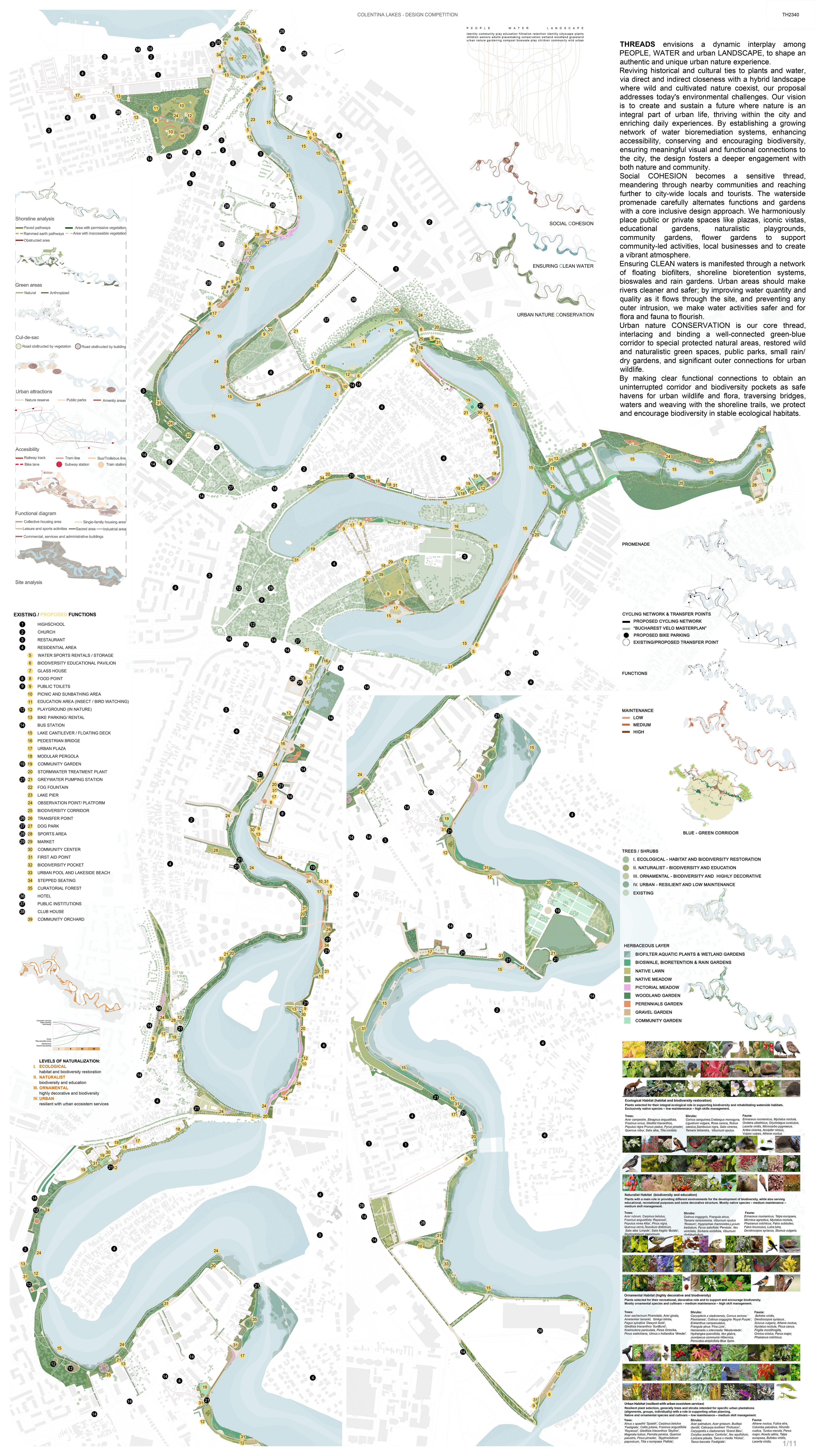
THREADS envisions a dynamic interplay among PEOPLE, WATER and urban LANDSCAPE, to shape an authentic and unique urban nature experience.
Reviving historical and cultural ties to plants and water, via direct and indirect closeness with a hybrid landscape where wild and cultivated nature coexist, our proposal addresses today’s environmental challenges. Our vision is to create and sustain a future where nature is an integral part of urban life, thriving within the city and enriching daily experiences. By establishing a growing network of water bioremediation systems, enhancing accessibility, conserving and encouraging biodiversity, ensuring meaningful visual and functional connections to the city, the design fosters a deeper engagement with both nature and community.
Social COHESION, becomes a sensitive thread, meandering through nearby communities and reaching further to city-wide locals and tourists. The waterside promenade carefully alternates functions and gardens with a core inclusive design approach. We harmoniously place public or private spaces like plazas, iconic vistas, educational gardens, naturalistic playgrounds, community gardens, flower gardens to support community-led activities, local businesses and to create a vibrant atmosphere.
Ensuring CLEAN waters, is manifested through a network of floating biofilters, shoreline bioretention systems, bioswales and rain gardens. Urban areas should make rivers cleaner and safer; by improving water quantity and quality as it flows through the site, and preventing any outer intrusion, we make water activities safer and for flora and fauna to flourish.
Urban nature CONSERVATION is our core thread, interlacing and binding a well-connected green-blue corridor to special protected natural areas, restored wild and naturalistic green spaces, public parks, small rain/ dry gardens, and significant outer connections for urban wildlife.
By making clear functional connections to obtain an uninterrupted corridor and biodiversity pockets as safe havens for urban wildlife and flora, traversing bridges, waters and weaving with the shoreline trails, we protect and encourage biodiversity in stable ecological habitats.
Plansa 2
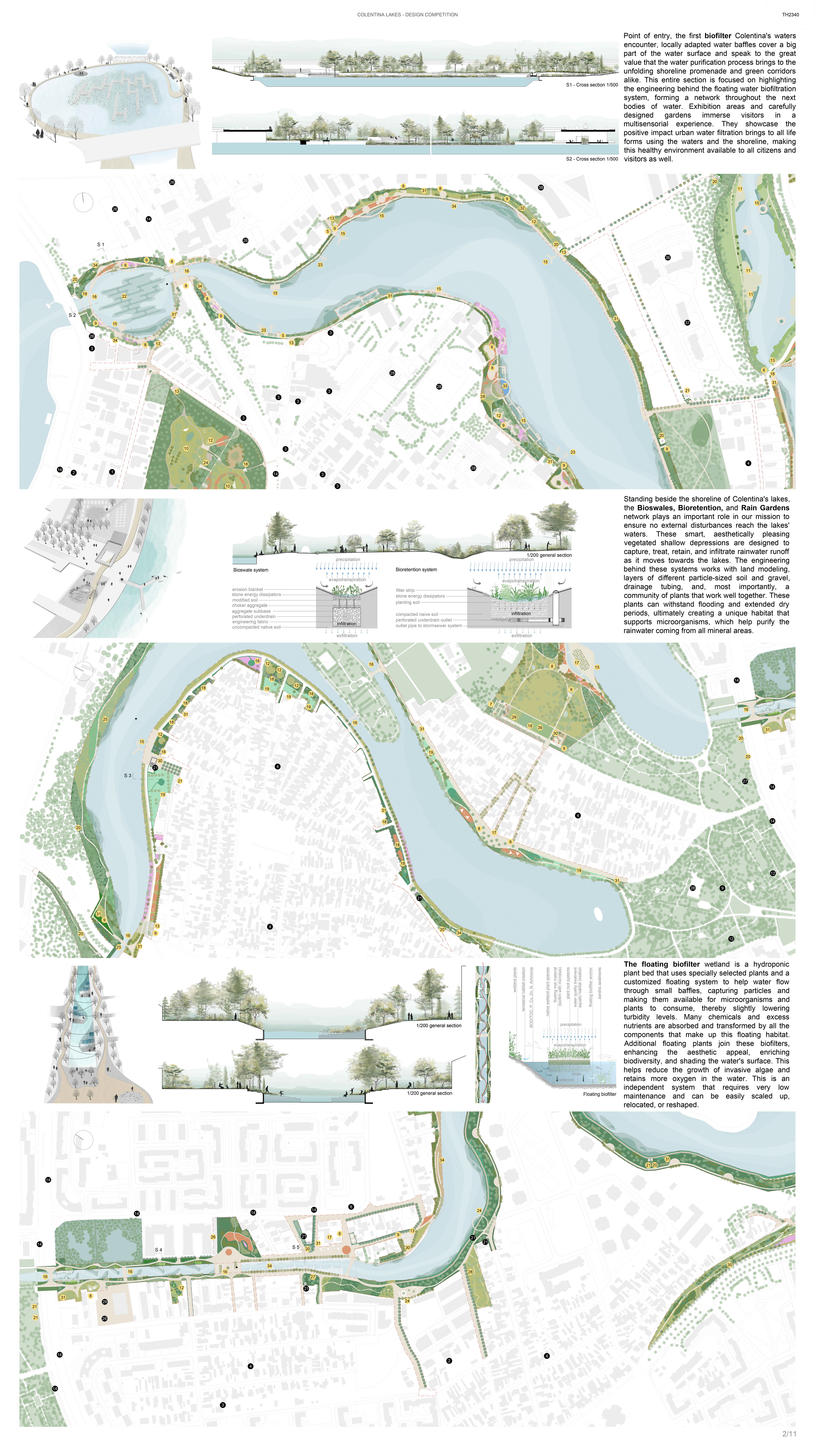
Point of entry, the first biofilter Colentina’s waters encounter, locally adapted water baffles that covers a big part of the water surface and speaks to the great value that the water purification process brings to the unfolding shoreline promenade and green corridors alike. This entire section is focused on highlighting the engineering behind the floating water biofiltration system, forming a network throughout the following bodies of water. Expositional areas and carefully designed gardens immerse visitors in a multisensorial experience, perfectly showcasing the positive impact urban water filtration brings to all life forms using the waters and the shoreline, making this healthy environment available to all citizens and visitors as well.
Standing beside the shoreline of Colentina’s lakes, the Bioswales, Bioretention, and Rain Gardens network plays an important role in our mission to ensure no external disturbances reach the lakes’ waters. These smart, aesthetically pleasing vegetated shallow depressions are designed to capture, treat, retain, and infiltrate rainwater runoff as it moves towards the lakes. The engineering behind these systems works with land modeling, layers of different particle-sized soil and gravel, drainage tubing, and, most importantly, a community of plants that work well together. These plants can withstand flooding and extended dry periods, ultimately creating a unique habitat that supports microorganisms, which help purify the rainwater coming from all mineral areas.
The floating biofilter wetland is a hydroponic plant bed that uses specially selected plants and a customized floating system to help water flow through small baffles, capturing particles and making them available for microorganisms and plants to consume, thereby slightly lowering turbidity levels. Many chemicals and excess nutrients are absorbed and transformed by all the components that make up this floating habitat. Additional floating plants join these biofilters, enhancing the aesthetic appeal, enriching biodiversity, and shading the water’s surface. This helps reduce the growth of invasive algae and retains more oxygen in the water. This is an independent system that requires very low maintenance and can be easily scaled up, relocated, or reshaped.
Planșa 3
Plansa 4
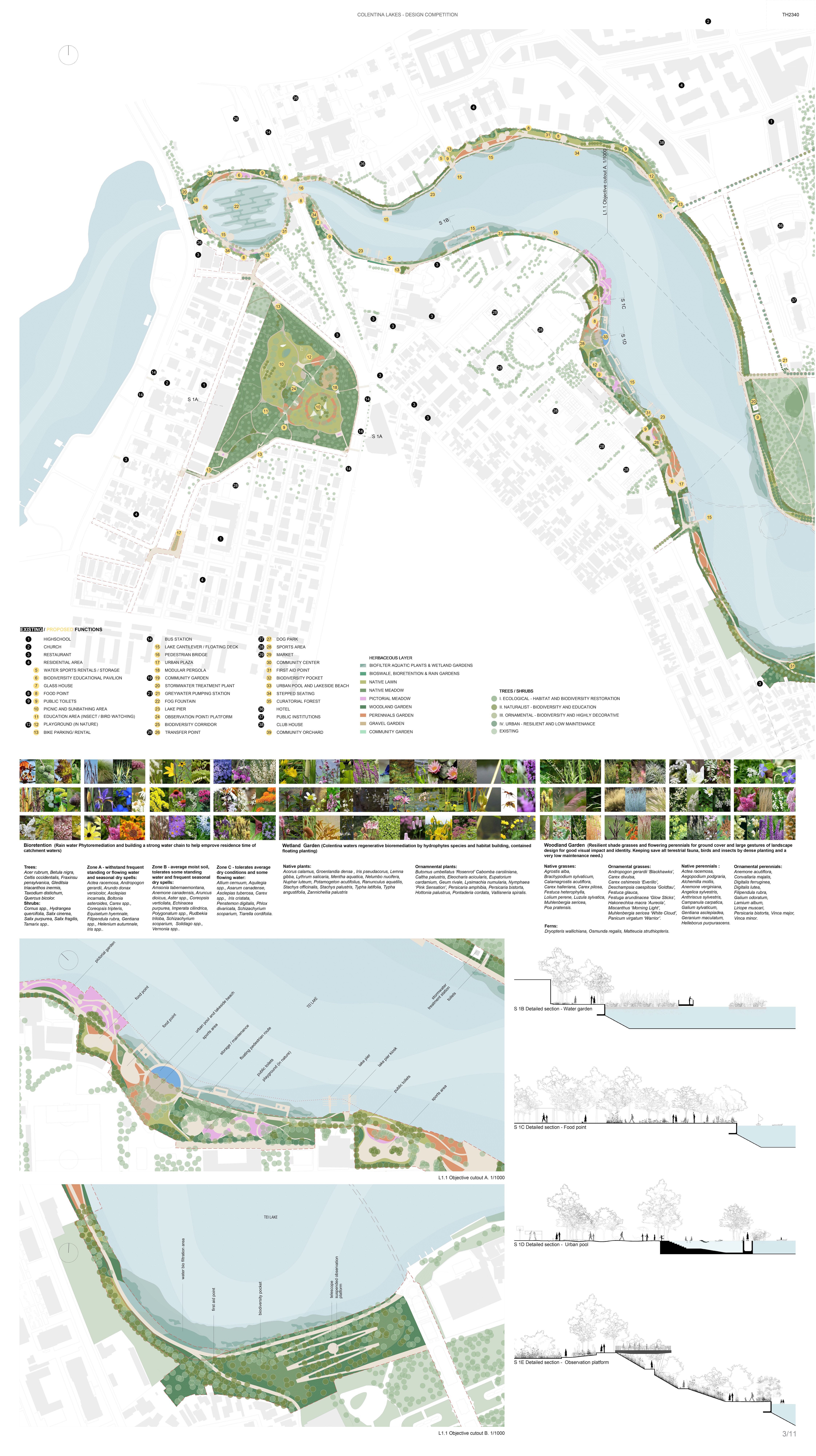
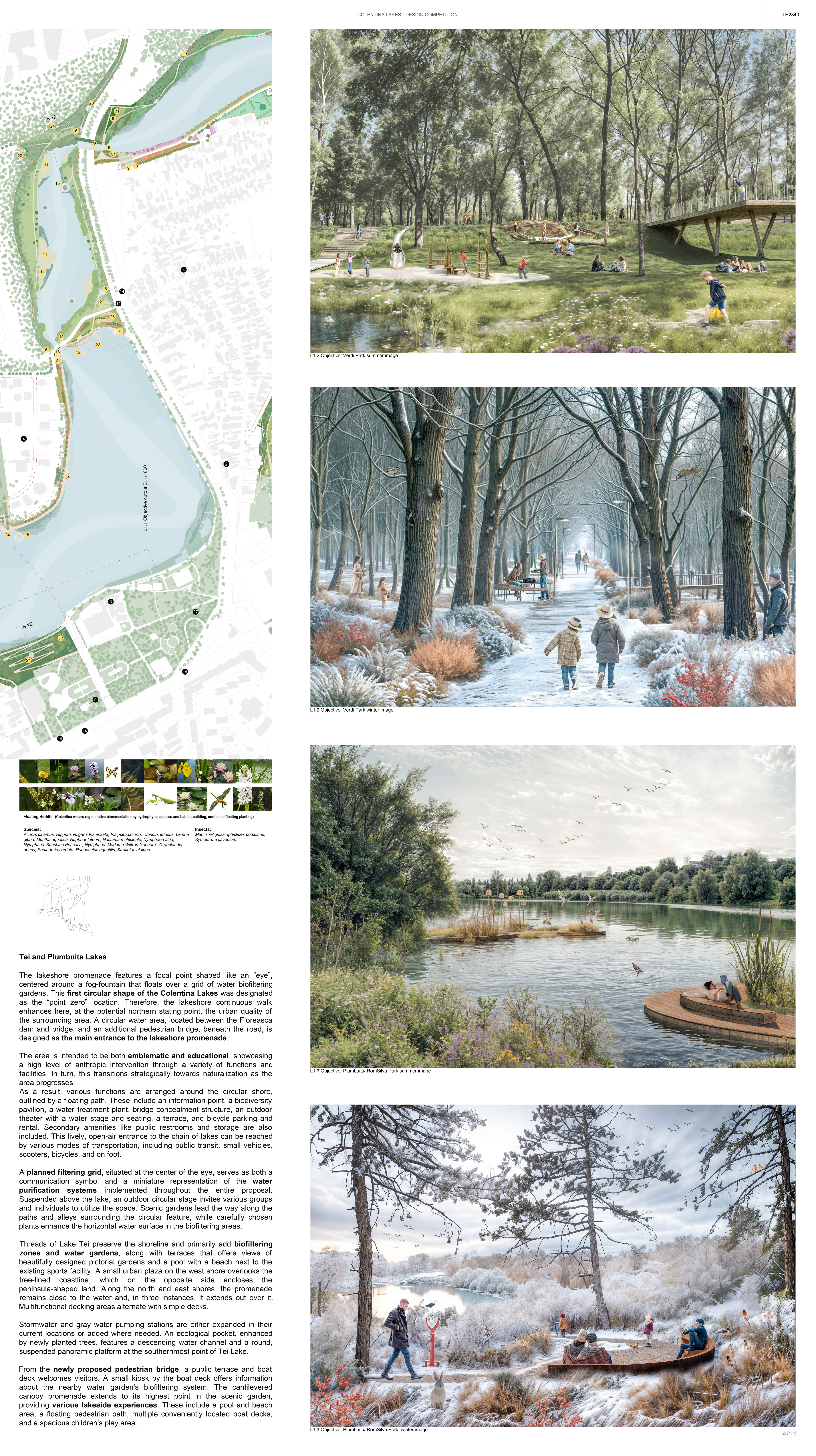
The lakeshore promenade features a focal point shaped like an “eye”, centered around a fog-fountain that floats over a grid of water biofiltering gardens. This first circular shape of the Colentina Lakes was designated as the “point zero” location. Therefore, the lakeshore continuous walk enhances here, at the potential northern stating point, the urban quality of the surrounding area. A circular water area, located between the Floreasca dam and bridge, and an additional pedestrian bridge, beneath the road, is designed as the main entrance to the lakeshore promenade.
The area is intended to be both emblematic and educational, showcasing a high level of anthropic intervention through a variety of functions and facilities. This, in turn, transitions strategically towards naturalization as the area progresses.
As a result, various functions are arranged around the circular shore, outlined by a floating path. These include an information point, a biodiversity pavilion, a water treatment plant, bridge concealment structure, an outdoor theater with a water stage and seating, a terrace, and bicycle parking and rental. Secondary amenities like public restrooms and storage are also included. This lively, open-air entrance to the chain of lakes can be reached by various modes of transportation, including public transit, small vehicles, scooters, bicycles, and on foot.
A planned filtering grid, situated at the center of the eye, serves as both a communication symbol and a miniature representation of the water purification systems implemented throughout the entire proposal. Suspended above the lake, an outdoor circular stage invites various groups and individuals to utilize the space. Scenic gardens lead the way along the paths and alleys surrounding the circular feature, while carefully chosen plants enhance the horizontal water surface in the biofiltering areas.
Threads of Lake Tei preserve the shoreline and primarily add biofiltering zones and water gardens, along with terraces that offers views of beautifully designed pictorial gardens and a pool with a beach next to the existing sports facility. A small urban plaza on the west shore overlooks the tree-lined coastline, which on the opposite side encloses the peninsula-shaped land. Along the north and east shores, the promenade remains close to the water and, in three instances, it extends out over it. Multifunctional decking areas alternate with simple decks.
Stormwater and gray water pumping stations are either expanded in their current locations or added where needed. An ecological pocket, enhanced by newly planted trees, features a descending water channel and a round, suspended panoramic platform at the southernmost point of Tei Lake.
From the newly proposed pedestrian bridge, a public terrace and boat deck welcomes visitors. A small kiosk by the boat deck offers information about the nearby water garden’s biofiltering system. The cantilevered canopy promenade extends to its highest point in the scenic garden, providing various lakeside experiences. These include a pool and beach area, a floating pedestrian path, multiple conveniently located boat decks, and a spacious children’s play area.
Plansa 5
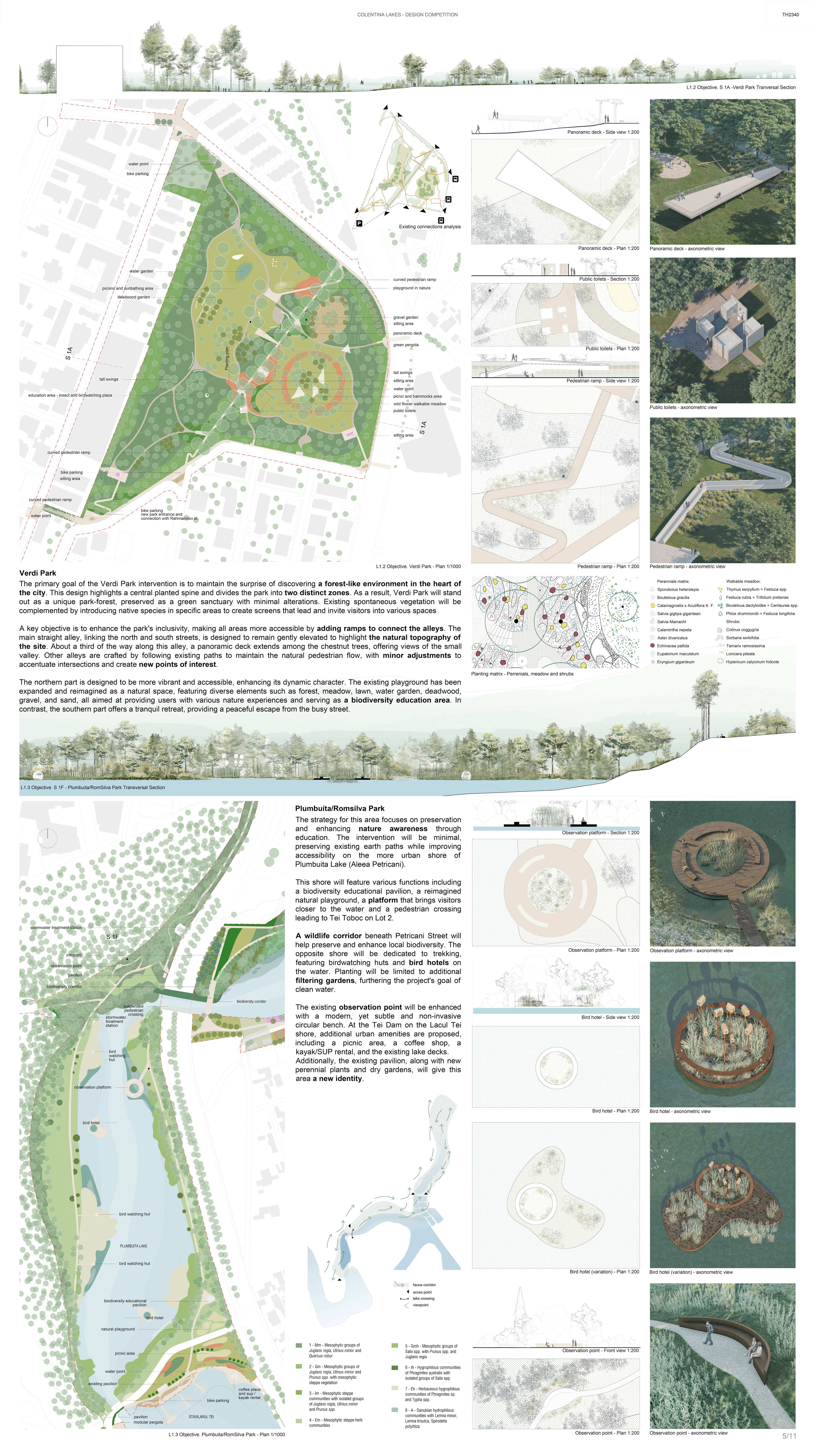
Verdi park
The primary goal of the Verdi Park intervention is to maintain the surprise of discovering a forest-like environment in the heart of the city. This design highlights a central planted spine and divides the park into two distinct zones. As a result, Verdi Park will stand out as a unique park-forest, preserved as a green sanctuary with minimal alterations. Existing spontaneous vegetation will be complemented by introducing native species in specific areas to create screens that lead and invite visitors into various spaces
A key objective is to enhance the park’s inclusivity, making all areas more accessible by adding ramps to connect the alleys. The main straight alley, linking the north and south streets, is designed to remain gently elevated to highlight the natural topography of the site. About a third of the way along this alley, a panoramic deck extends among the chestnut trees, offering views of the small valley. Other alleys are crafted by following existing paths to maintain the natural pedestrian flow, with minor adjustments to accentuate intersections and create new points of interest.
The northern part is designed to be more vibrant and accessible, enhancing its dynamic character. The existing playground has been expanded and reimagined as a natural space, featuring diverse elements such as forest, meadow, lawn, water garden, deadwood, gravel, and sand, all aimed at providing users with various nature experiences and serving as a biodiversity education area. In contrast, the southern part offers a tranquil retreat, providing a peaceful escape from the busy street.
Plumbuita Lake/RomSilva
The strategy for this area focuses on preservation and enhancing nature awareness through education. The intervention will be minimal, preserving existing earth paths while improving accessibility on the more urban shore of Plumbuita Lake (Aleea Petricani).
This shore will feature various functions including a biodiversity educational pavilion, a reimagined natural playground, a platform that brings visitors closer to the water and a pedestrian crossing leading to Tei Toboc on Lot 2.
A wildlife corridor beneath Petricani Street will help preserve and enhance local biodiversity. The opposite shore will be dedicated to trekking, featuring birdwatching huts and bird hotels on the water. Planting will be limited to additional filtering gardens, furthering the project’s goal of clean water.
The existing observation point will be enhanced with a modern, yet subtle and non-invasive circular bench. At the Tei Dam on the Lacul Tei shore, additional urban amenities are proposed, including a picnic area, a coffee shop, a kayak/SUP rental, and the existing lake decks.
Additionally, the existing pavilion, along with new perennial plants and dry gardens, will give this area a new identity.
LOT 2 – MENȚIUNEA 3
Plansa 6
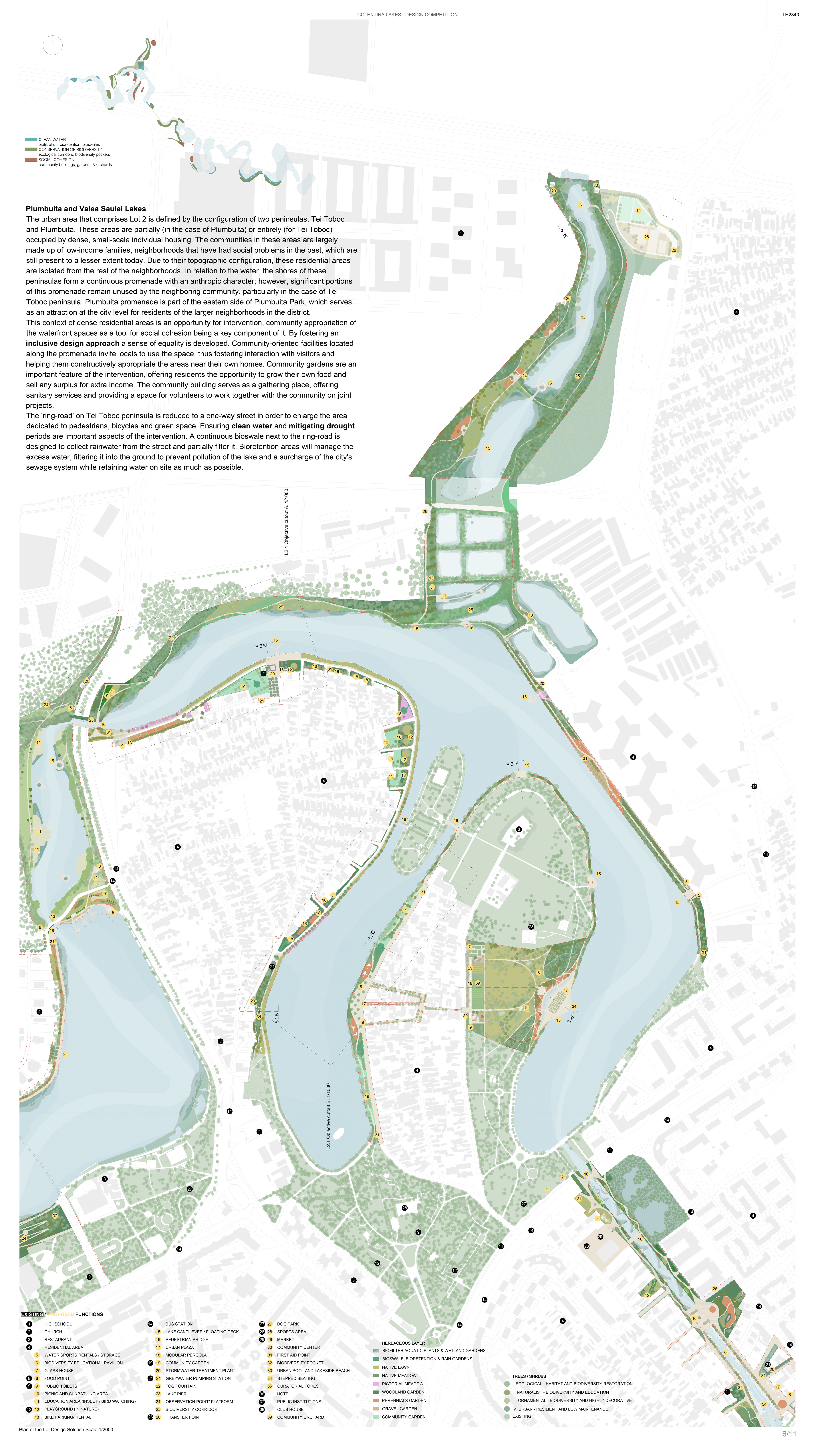
Plumbuita and Valea Saulei Lakes
The urban area that comprises Lot 2 is defined by the configuration of two peninsulas: Tei Toboc and Plumbuita. These areas are partially (in the case of Plumbuita) or entirely (for Tei Toboc) occupied by dense, small-scale individual housing. The communities in these areas are largely made up of low-income families, neighborhoods that have had social problems in the past, which are still present to a lesser extent today. Due to their topographic configuration, these residential areas are isolated from the rest of the neighborhoods. In relation to the water, the shores of these peninsulas form a continuous promenade with an anthropic character; however, significant portions of this promenade remain unused by the neighboring community, particularly in the case of Tei Toboc peninsula. Plumbuita promenade is part of the eastern side of Plumbuita Park, which serves as an attraction at the city level for residents of the larger neighborhoods in the district.
This context of dense residential areas is an opportunity for intervention, community appropriation of the waterfront spaces as a tool for social cohesion being a key component of it. By fostering an inclusive design approach a sense of equality is developed. Community-oriented facilities located along the promenade invite locals to use the space, thus fostering interaction with visitors and helping them constructively appropriate the areas near their own homes. Community gardens are an important feature of the intervention, offering residents the opportunity to grow their own food and sell any surplus for extra income. The community building serves as a gathering place, offering sanitary services and providing a space for volunteers to work together with the community on joint projects.
The ‘ring-road’ on Tei Toboc peninsula is reduced to a one-way street in order to enlarge the area dedicated to pedestrians, bicycles and green space. Ensuring clean water and mitigating drought periods are important aspects of the intervention. A continuous bioswale next to the ring-road is designed to collect rainwater from the street and partially filter it. Bioretention areas will manage the excess water, filtering it into the ground to prevent pollution of the lake and a surcharge of the city’s sewage system while retaining water on site as much as possible.
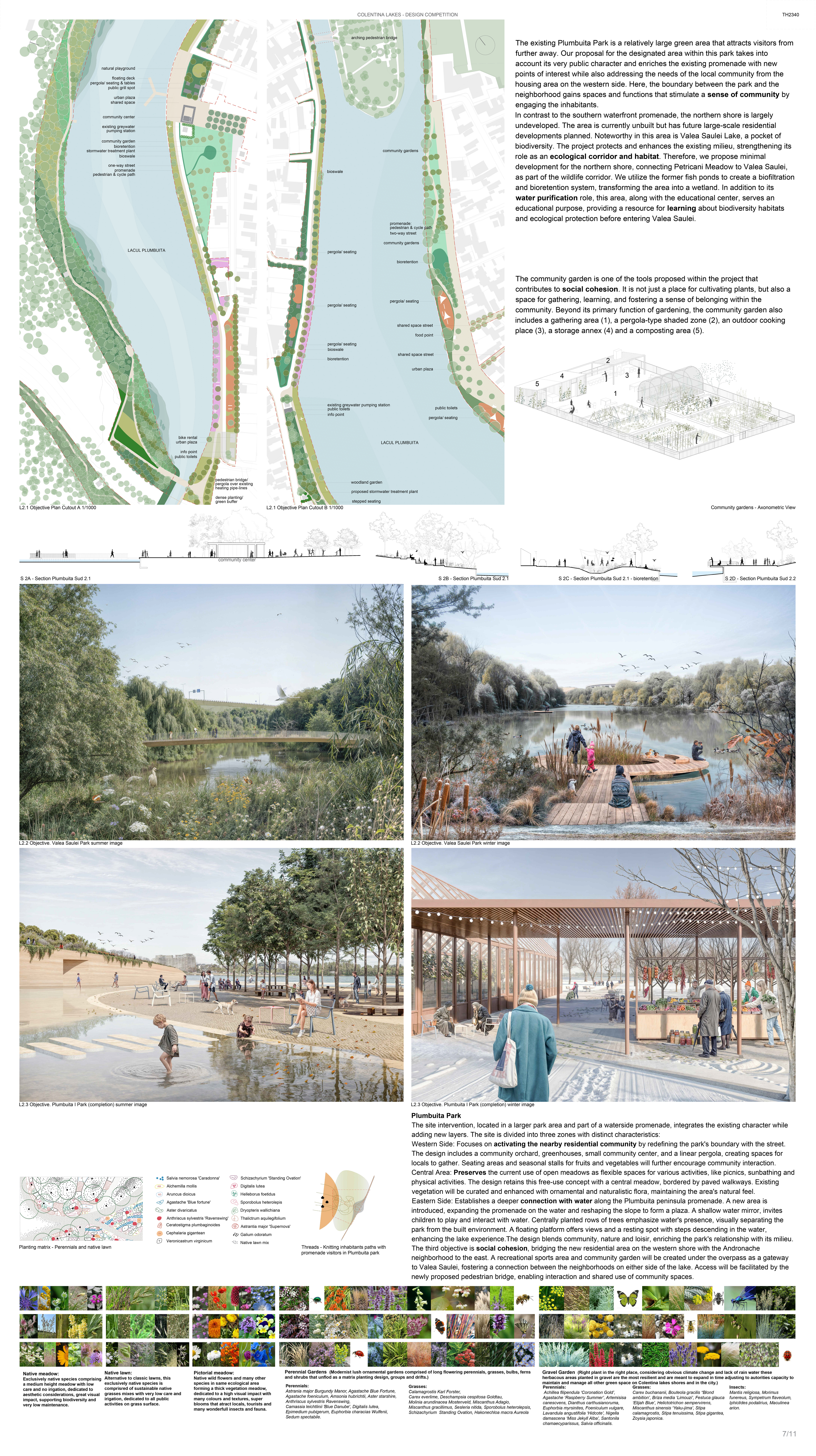
The existing Plumbuita Park is a relatively large green area that attracts visitors from further away. Our proposal for the designated area within this park takes into account its very public character and enriches the existing promenade with new points of interest while also addressing the needs of the local community from the housing area on the western side. Here, the boundary between the park and the neighborhood gains spaces and functions that stimulate a sense of community by engaging the inhabitants.
In contrast to the southern waterfront promenade, the northern shore is largely undeveloped. The area is currently unbuilt but has future large-scale residential developments planned. Noteworthy in this area is Valea Saulei Lake, a pocket of biodiversity. The project protects and enhances the existing milieu, strengthening its role as an ecological corridor and habitat. Therefore, we propose minimal development for the northern shore, connecting Petricani Meadow to Valea Saulei, as part of the wildlife corridor. We utilize the former fish ponds to create a biofiltration and bioretention system, transforming the area into a wetland. In addition to its water purification role, this area, along with the educational center, serves an educational purpose, providing a resource for learning about biodiversity habitats and ecological protection before entering Valea Saulei.
The community garden is one of the tools proposed within the project that contributes to social cohesion. It is not just a place for cultivating plants, but also a space for gathering, learning, and fostering a sense of belonging within the community. Beyond its primary function of gardening, the community garden also includes a gathering area (1), a pergola-type shaded zone (2), an outdoor cooking place (3), a storage annex (4) and a composting area (5).
Plansa 7
Plumbuita Park
The site intervention, located in a larger park area and part of a waterside promenade, integrates the existing character while adding new layers. The site is divided into three zones with distinct characteristics:
Western Side: Focuses on activating the nearby residential community by redefining the park’s boundary with the street. The design includes a community orchard, greenhouses, small community center, and a linear pergola, creating spaces for locals to gather. Seating areas and seasonal stalls for fruits and vegetables will further encourage community interaction.
Central Area: Preserves the current use of open meadows as flexible spaces for various activities, like picnics, sunbathing and physical activities. The design retains this free-use concept with a central meadow, bordered by paved walkways. Existing vegetation will be curated and enhanced with ornamental and naturalistic flora, maintaining the area’s natural feel.
Eastern Side: Establishes a deeper connection with water along the Plumbuita peninsula promenade. A new area is introduced, expanding the promenade on the water and reshaping the slope to form a plaza. A shallow water mirror, invites children to play and interact with water. Centrally planted rows of trees emphasize water’s presence, visually separating the park from the built environment. A floating platform offers views and a resting spot with steps descending in the water, enhancing the lake experience.The design blends community, nature and loisir, enriching the park’s relationship with its milieu.
The third objective is social cohesion, bridging the new residential area on the western shore with the Andronache neighborhood to the east. A recreational sports area and community garden will be created under the overpass as a gateway to Valea Saulei, fostering a connection between the neighborhoods on either side of the lake. Access will be facilitated by the newly proposed pedestrian bridge, enabling interaction and shared use of community spaces.
Plansa 8
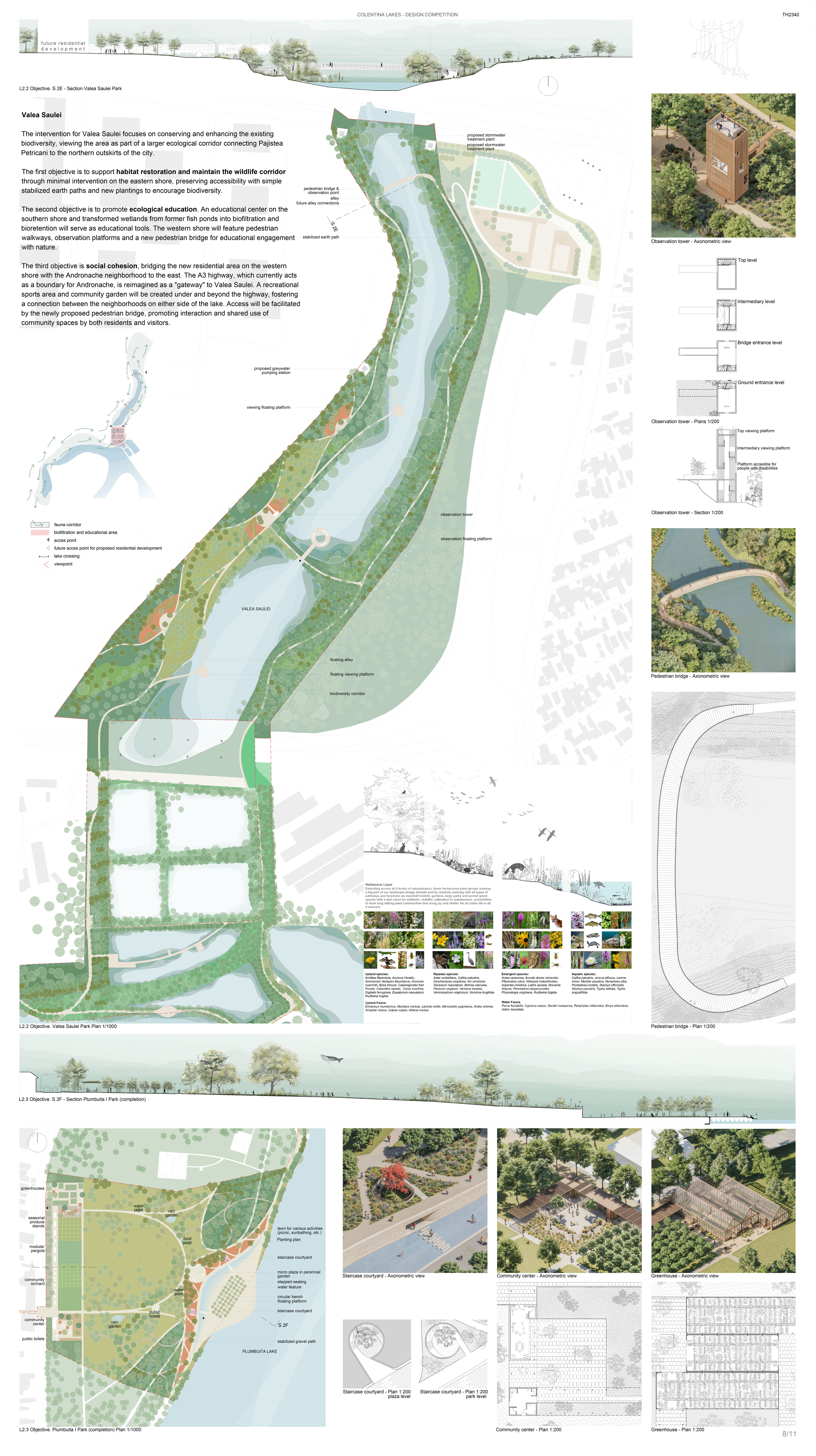
Valea Saulei
The intervention for Valea Saulei focuses on conserving and enhancing the existing biodiversity, viewing the area as part of a larger ecological corridor connecting Pajistea Petricani to the northern outskirts of the city.
The first objective is to support habitat restoration and maintain the wildlife corridor through minimal intervention on the eastern shore, preserving accessibility with simple stabilized earth paths and new plantings to encourage biodiversity.
The second objective is to promote ecological education. An educational center on the southern shore and transformed wetlands from former fish ponds into biofiltration and bioretention will serve as educational tools. The western shore will feature pedestrian walkways, observation platforms and a new pedestrian bridge for educational engagement with nature.
The third objective is social cohesion, bridging the new residential area on the western shore with the Andronache neighborhood to the east. The A3 highway, which currently acts as a boundary for Andronache, is reimagined as a “gateway” to Valea Saulei. A recreational sports area and community garden will be created under and beyond the highway, fostering a connection between the neighborhoods on either side of the lake. Access will be facilitated by the newly proposed pedestrian bridge, promoting interaction and shared use of community spaces by both residents and visitors.