


117 – UB2207 – URBAN SCOPE SRL
Autor principal: arh. Claudia Slivinschi, Ana-Maria Furnică – urbanist, Anca Elena Rusovici – urbanist, Simina Stan – urbanist, Raluca Vișan – urbanist, Alexandru Rusovici – urbanist
Colaboratori arhitectură: arh. Albert Sebastian Dobrin
Colaboratori specialități: Atena Ioana Gârjoabă – urbanist peisagist
LOT 1 – Locul 14
LOT 2 – Locul 11
LOT 3 – Locul 11
Sheet 1(EN)
Text 1:The proposed general concept aims to create a continuous green-blue corridor that integrates the ecological, recreational, social, and cultural functions of the areas. This initiative seeks to improve the quality of life for residents and increase the attractiveness of both Sector 2 and the Municipality of Bucharest.
Text 2: One of the project’s main objectives is to restore the continuity of the public pathway along the lake shores. This green-blue corridor will provide an uninterrupted promenade, suitable for both pedestrian and bicycle traffic.
Text 3: The primary objective of the concept is to enhance the relationship between the lake shores and the surrounding urban neighborhoods by proposing development solutions that incorporate existing natural elements, such as spontaneous vegetation and local wildlife. The goal is to preserve and enhance these elements as part of the urban landscape, contributing to the creation of an attractive and healthy environment. The concept also encourages preserving the site’s memory by integrating historical and cultural elements into the new developments.
Text 4: The general landscape design concept is based on the development of an integrated green system, oriented along two main directions. The first direction, east-west, aims at achieving visual and functional coherence of the landscape along the lake shores. The second direction, north-south, focuses on connecting the landscape of the chain of lakes with the green space system of Bucharest and the surrounding localities.
Sheet 2 (EN)
Text 1: The lake shores will be equipped with urban furniture and amenities to ensure user comfort and safety. Additionally, the project proposes the development of themed areas of interest on the lakes, such as floating platforms, designed in a way that does not interfere with the natural functions of the water. The project adopts a flexible approach, allowing for adaptation and further development in subsequent phases, depending on available resources and the evolving needs of the community.
Text 2: The landscape proposal approached the implementation area through two components: landscape segments and landscape nodes/poles. The segments aim to highlight the identity of the areas along the shoreline, which differ functionally, historically, and ecologically. The nodes serve as key points in the design, connecting either two segments or the implementation area with adjacent spaces.
Sheet 3 (EN)
Text 1: The development project for Lot 1 aims to revitalize and integrate the area into a coherent system of green and blue spaces, tailored to the needs of the local community and visitors. Lot 1 includes the lakeshores, part of Tei Park, and Verdi Park, and is structured into various spatial typologies, connected by promenades and bicycle paths. Each area benefits from specific interventions, contributing to the creation of an attractive, functional, and sustainable public space.
The landscape is designed to connect two main objectives: Verdi Park and Petricani Meadow, using promenade paths. This connection is achieved through rows of tall vegetation (deciduous trees) and medium-height vegetation (ornamental grasses), creating a natural transition between the two green spaces and integrating the meadow into the urban context.
Text 2: The development project for Lot 1 places a strong emphasis on integrating vegetation and architectural elements to create an attractive and functional public space that meets the needs of the community. The selection of plant species adjacent to the promenade took into account adjacent functions, as well as thermal and visual comfort during passage, and the available space for implementation.
The “entrance gateway” at the western end of Lot 1 is highlighted by groups of ornamental grasses on the northern side and a row of deciduous trees on the southern side. The yellow ornamental grasses enliven the space with golden blooms in the autumn and yellow leaves during the cold season. These plants retain their shape and color in winter, and in spring, they are pruned to allow for regeneration. Along the secondary paths, silver linden trees (Tilia tomentosa) are proposed, becoming a visual landmark in spring and summer due to their blossoms and distinctive form.
Along the main promenade, species with both aesthetic and functional roles are used: Populus for height, Quercus rubra for color accents, and groups of Salix babylonica along the waterfront to create a natural rhythm. The access area near Tei Park is marked by a mass of deciduous trees, evergreen shrub clusters that enliven the space in winter, and deciduous shrubs with red foliage for a vibrant visual effect in the warm season.
Architecturally, contemplation and relaxation points will be developed. On the northern shore of Lake Tei, bordered by proposed tall vegetation, there will be contemplation areas, short secondary paths, and minimal pontoons large enough to host small events that will animate the space.
On the southern shore, existing platforms will become public open spaces, and minimal food service points will be installed. South of the proposed lake crossing, multifunctional bleachers will be built, capable of hosting various events. In Tei Park, the “House of Horrors” building will be transformed into a flower market, and the rollercoaster platform will host a farmer’s market. The stairs descending to the lakeshore will be repurposed into four distinct plazas, arranged at different heights.
Sheet 5 (EN)
Text 1: The four main access points proposed for Verdi Park are emphasized by planting deciduous trees of the Quercus rubra species, which provide a distinctive red color, contributing to a vibrant landscape year-round. Given the park’s proximity to private lands on the western side, the need for a clear physical boundary was recognized. To separate the two areas, a mass of evergreen trees has been proposed, providing a visual and functional barrier throughout the year. Symmetrically, on the eastern side along Barbu Văcărescu Street, a mass of deciduous trees has been proposed to highlight this section adjacent to the park.
The main circulation axis, which already exists, has been preserved and marked by groups of red-colored shrubs placed on either side of the path, creating a natural and orderly rhythm as people traverse the space. Compositional groups of three types of shrubs, each differing in form, color, and height, have been introduced to provide visual animation year-round.
To increase the park’s attractiveness, multiple activities have been planned, including playgrounds, community spaces, and picnic areas. The pathway system has been optimized, offering four main access points, each marked by larger paved areas where small food service points and public restroom facilities will be installed. Additionally, the local streets surrounding the park have been transformed into shared spaces.
Text 2: Given the ecological value of Petricani Meadow, the proposed interventions in this area have been limited and carefully planned to maintain the natural balance. In the western part, small groups of ornamental grasses have been proposed to mark the access points from both the south and the north. The same types of ornamental grasses have been planted on the eastern shore, in the southern area, to indicate access to the meadow and suggest the possibility of “crossing” the lake.
Also, on the eastern shore, three trees of the Tilia tomentosa species have been proposed, serving as olfactory landmarks during the warm season due to the pleasant scent of their flowers. In the northern part of the site, columnar trees from the Populus genus have been planted, acting as tall visual markers, indicating the eastern entrance to the meadow.
The proposals for this area focus on creating an integrated and sustainable public space that highlights the natural and scenic potential of the Colentina lakes.
One of the major interventions in this area is the construction of a perforated floating pontoon, where aquatic plants will be placed, contributing to the lake’s biodiversity. In the western part, minimal organic gravel paths are proposed to minimize environmental impact, and there will be observation points for studying the fauna, offering visitors a direct connection with nature.
Text 3: A lightweight structure with a rectangular, modular composition designed to adapt to various functional needs. To better integrate with the natural environment, treated wood and recycled materials are preferred.
Text 4: A lightweight structure with a rectangular, modular composition designed to adapt to various functional needs. To integrate with the natural environment, treated wood and recycled materials are preferred.
Text 5: The bicycle workshop complements the future recreational/ sport cycling infrastructure. These serve as small quick-intervention points in case of a bike malfunction.
Text 6: A mineral construction of strict public necessity, these structures will serve various areas throughout the proposed development. They are designed to meet essential needs and ensure functionality across different zones of the site.
Text 7: The bird observation tower is a lightweight structure with a minimalist design. The slats allow the structure to be naturally ventilated and illuminated, while also providing some concealment for bird watchers, reducing the likelihood of startling nearby birds.
Text 8: Functional points placed along the cycling paths, designed as markers, made from wood and equipped with a small air pump.
Text 9: The proposed furniture includes modern benches made of solid concrete in varying shades, paired with hardwood or thermally treated wood slats. They feature galvanized or stainless steel elements and can be anchored to pavement. The adaptable trash bins are designed for public spaces, with options for perforated steel, wood, or aluminum slats, supported by a steel-aluminum structure and secure lid.
Sheet 6 (EN)
Lot 2 represents an essential segment of the Colentina Lakes rehabilitation project in Sector 2 of Bucharest. The development proposals aim to capitalize on the ecological, recreational, and cultural potential of this area by combining the modernization of existing infrastructure with biodiversity conservation and the creation of new spaces for socializing and nature observation.
A distinctive feature of Lot 2 is the presence of numerous connection nodes relative to its surface area. In addition to the two existing nodes at the eastern and western extremities, the area is connected to two other important points in the urban network along the lake shores. The first node is the island linking the Tei Toboc neighborhood to Plumbuita Park, while the second is the basins in the access area toward Valea Saulei. Considering these compositional elements, the design of the promenade path has been planned to ensure landscape continuity between these nodes while also differentiating the segments with varied scenic elements, offering visual diversity.
For the two objectives adjacent to the promenade, distinct approaches have been adopted, tailored to the specific character of each area. Valea Saulei Park has been treated minimally regarding new plant species insertions, considering its high ecological value and the existing tall, dense vegetation. In contrast, for Plumbuita Park, known for its recreational role, a diversified landscape design has been proposed, introducing a variety of colors and plant species, enhancing the visual and functional appeal of the space.
Sheet 7 (EN)
The promenade adjacent to the shores included in Lot 2 is defined by landscape diversity, reflecting the functional and morphological mix of the surrounding urban fabric. This variety is evident in the different segments, described from west to east, with a dendrological approach adapted to each area.
At the western end of the lot, both on the northern and southern shores, groups and rows of deciduous trees with red foliage, evergreen shrubs, and yellow ornamental grasses have been proposed, bringing visual and functional dynamism. The spaces dedicated to recreational and sports activities are accentuated by the inclusion of red-foliage trees, providing a strong visual impact and creating an attractive setting for these activities. The access to Valea Saulei Park is marked by ground-cover plants and groups of evergreen shrubs, contributing to a natural and pleasant boundary along the path.
In the eastern part of Plumbuita Island, solitary trees are proposed for recreational and sports areas, providing thermal comfort during the warm season. On the southern segment of the island, rows of deciduous trees are proposed, creating a rhythm throughout the space, accompanied by compositional groups of varied plant species in terms of shape, color, and height. Additionally, evergreen trees will provide continuity and visual appeal during the cold season, contributing to a balanced landscape year-round.
In the northeastern part of Plumbuita Park, a minimalist approach has been chosen to avoid competing visually with the silhouette of Plumbuita Monastery on the opposite shore. Here, rows of green deciduous trees will maintain a natural and simple aesthetic. Continuing along this segment, solitary trees and groups of ornamental grasses are planned, subtly enhancing the landscape’s diversity without visually overloading the area.
To ensure a complete and well-defined circuit between the northern and southern shores, a pedestrian and bicycle overpass is proposed in the western area of the lot, supported by a system of poles and cables, facilitating easy access between the two sides. In the Tei-Toboc area, where the shores are wider, multiple community spaces, playgrounds, and sports fields are planned, creating additional activity areas for residents. Furthermore, the perimeter circulation is designed as shared space, emphasizing the proposed activities and promoting social interaction in a safe and accessible environment.
On both shores, south of Plumbuita Island, shared spaces are proposed, allowing for the coexistence of pedestrian and vehicular activities. In areas where interventions are possible, small squares with leisure and social functions will be created, along with contemplation points, offering attractive spaces for relaxation and nature observation. These measures contribute to creating a dynamic and accessible landscape, harmoniously integrated into the urban context.
Sheet 8 (EN)
Text 1: Valea Saulei Park is recognized for its ecological value, and this aspect, along with the presence of existing tree masses, justified the need for minimal intervention in the area. Regarding the landscape design, groups of ornamental grasses have been proposed to mark the locations of temporary constructions while preserving the natural appearance of the zone.
Given the limited possibilities for intervention in Valea Saulei Park, clearly marking access to this area was considered essential. Adjacent to Lake Plumbuita, a green recreational space has been proposed, where a solitary red-foliage tree will serve as a chromatic landmark, adding a distinct visual element. This tree is surrounded by ground-cover plants, creating a natural transition in the landscape. Around this recreational space, masses of deciduous trees will be planted, accompanied by compositional groups of evergreen shrubs, to accentuate the boundary and maintain aesthetic balance throughout the seasons.
This arrangement extends northward toward Valea Saulei Park through rows of deciduous trees surrounding the aquifers, guiding the pathway along the lakeshore. The path directs visitors toward Valea Saulei, currently separated from the rest of the development by the A3 highway. To maintain the area’s natural character, only gravel pedestrian paths are proposed, ensuring minimal environmental impact.
Observation points for vegetation and wildlife will be discreet, strategically placed within the existing and newly proposed vegetation, offering visitors opportunities to observe nature without disturbing the sensitive ecosystem. These measures help maintain ecological balance and protect biodiversity while ensuring access and comfort for visitors.
Text 2:The area in Plumbuita Park proposed for development is defined by a pedestrian circulation system that has been preserved in the new landscape design. These paths are bordered by red and yellow vegetation to animate the space throughout the year, regardless of the season. The main access from Plumbuita Street is marked by a group of red-foliage trees framed by two groups of green-foliage trees, creating an attractive and contrasting visual effect.
The main path, which crosses the park from east to west, is highlighted by red-foliage shrubs from the species Photinia x fraseri, which can be used either as a row of shrubs or as a hedge.
To mark the proposed structure as a height landmark within the park, ground-cover plants are proposed.
The main architectural feature in this area is the multifunctional pavilion, located near the lakeshore. It is designed to serve as an architectural landmark for the entire chain of lakes.
Through these proposals, the Lake Plumbuita area will be transformed into a hub for recreation, education, and ecological conservation, harmoniously integrated into the urban landscape of Sector 2.
Text 3: The bird observation tower is a lightweight structure with a minimalist design. The slats allow the structure to be naturally ventilated and illuminated, while also providing some concealment for bird watchers, reducing the likelihood of startling nearby birds.
Text 4: A lightweight structure with a rectangular, modular composition designed to adapt seamlessly to various functional needs. To integrate with the natural environment, treated wood and recycled materials are primarily preferred for use.
Text 5: The bicycle workshop complements the future recreational/ sport bcycling infrastructure. These serve as small quick-intervention points in case of a bicycle breakdown or as simple resting spots for cyclists. They are placed to provide essential services, ensuring and enjoyable cycling experience.
Text 6: It serves as a small quick-intervention point in case of a bike malfunction. These strategically placed stations ensure convenience for cyclists along their routes
Text 7: A mineral construction of strict public necessity, these structures will serve various areas throughout the proposed development. They are designed to meet essential needs and ensure functionality across different zones of the site.
Text 8: Functional points placed along the cycling paths, designed as markers, made from wood and equipped with a small air pump.
Text 9: The proposed furniture includes modern benches made of solid concrete in varying shades, paired with hardwood or thermally treated wood slats. They feature galvanized or stainless steel elements and can be anchored to pavement. The adaptable trash bins are designed for public spaces, with options for perforated steel, wood, or aluminum slats, supported by a steel-aluminum structure and secure lid.
Text 10: The pavilion will be constructed from natural materials and earth-toned paints, with the main structure made of glass to integrate the building into the natural landscape. To emphasize this integration, the pavilion will not have direct access from the main pathway. Its architecture focuses on fluidity, interaction with the environment, and the seamless integration of interior and exterior spaces.
Sheet 9 (EN)
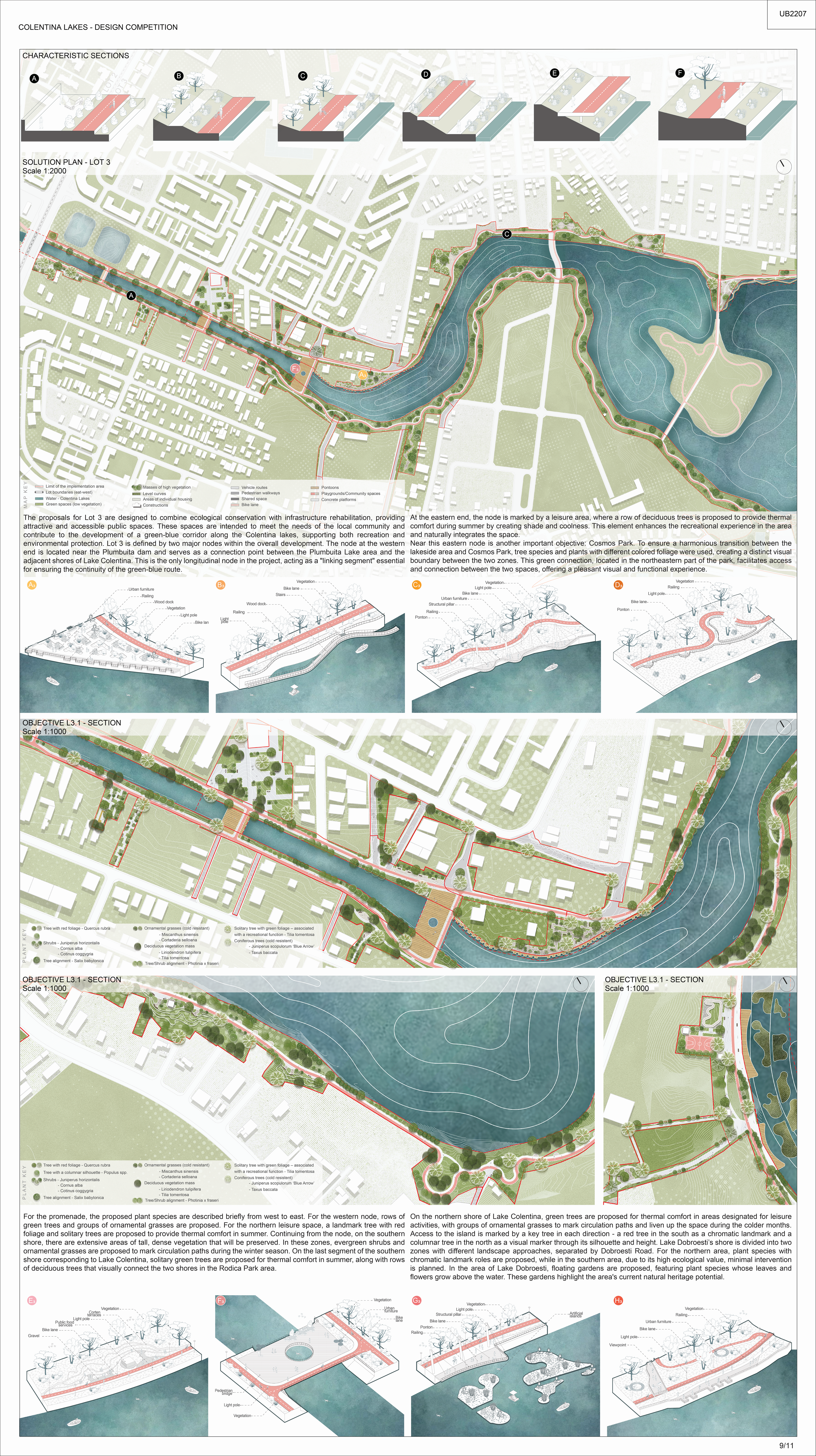
Text 1: The proposals for Lot 3 are designed to combine ecological conservation with infrastructure rehabilitation, providing attractive and accessible public spaces. These spaces are intended to meet the needs of the local community and contribute to the development of a green-blue corridor along the Colentina lakes, supporting both recreation and environmental protection.
Lot 3 is defined by two major nodes within the overall development. The node at the western end is located near the Plumbuita dam and serves as a connection point between the Plumbuita Lake area and the adjacent shores of Lake Colentina. This is the only longitudinal node in the project, acting as a “linking segment” essential for ensuring the continuity of the green-blue route.
At the eastern end, the node is marked by a leisure area, where a row of deciduous trees is proposed to provide thermal comfort during summer by creating shade and coolness. This element enhances the recreational experience in the area and naturally integrates the space.
Near this eastern node is another important objective: Cosmos Park. To ensure a harmonious transition between the lakeside area and Cosmos Park, tree species and plants with different colored foliage were used, creating a distinct visual boundary between the two zones. This green connection, located in the northeastern part of the park, facilitates access and connection between the two spaces, offering a pleasant visual and functional experience.
Text 2: For the promenade, the proposed plant species are described briefly from west to east. For the western node, rows of green trees and groups of ornamental grasses are proposed. For the northern leisure space, a landmark tree with red foliage and solitary trees are proposed to provide thermal comfort in summer. Continuing from the node, on the southern shore, there are extensive areas of tall, dense vegetation that will be preserved. In these zones, evergreen shrubs and ornamental grasses are proposed to mark circulation paths during the winter season. On the last segment of the southern shore corresponding to Lake Colentina, solitary green trees are proposed for thermal comfort in summer, along with rows of deciduous trees that visually connect the two shores in the Rodica Park area.
On the northern shore of Lake Colentina, green trees are proposed for thermal comfort in areas designated for leisure activities, with groups of ornamental grasses to mark circulation paths and liven up the space during the colder months. Access to the island is marked by a key tree in each direction— a red tree in the south as a chromatic landmark and a columnar tree in the north as a visual marker through its silhouette and height.
Lake Dobroesti’s shore is divided into two zones with different landscape approaches, separated by Dobroesti Road. For the northern area, plant species with chromatic landmark roles are proposed, while in the southern area, due to its high ecological value, minimal intervention is planned. In the area of Lake Dobroesti, floating gardens are proposed, featuring plant species whose leaves and flowers grow above the water. These gardens highlight the area’s current natural heritage potential.
Sheet 10 (EN)
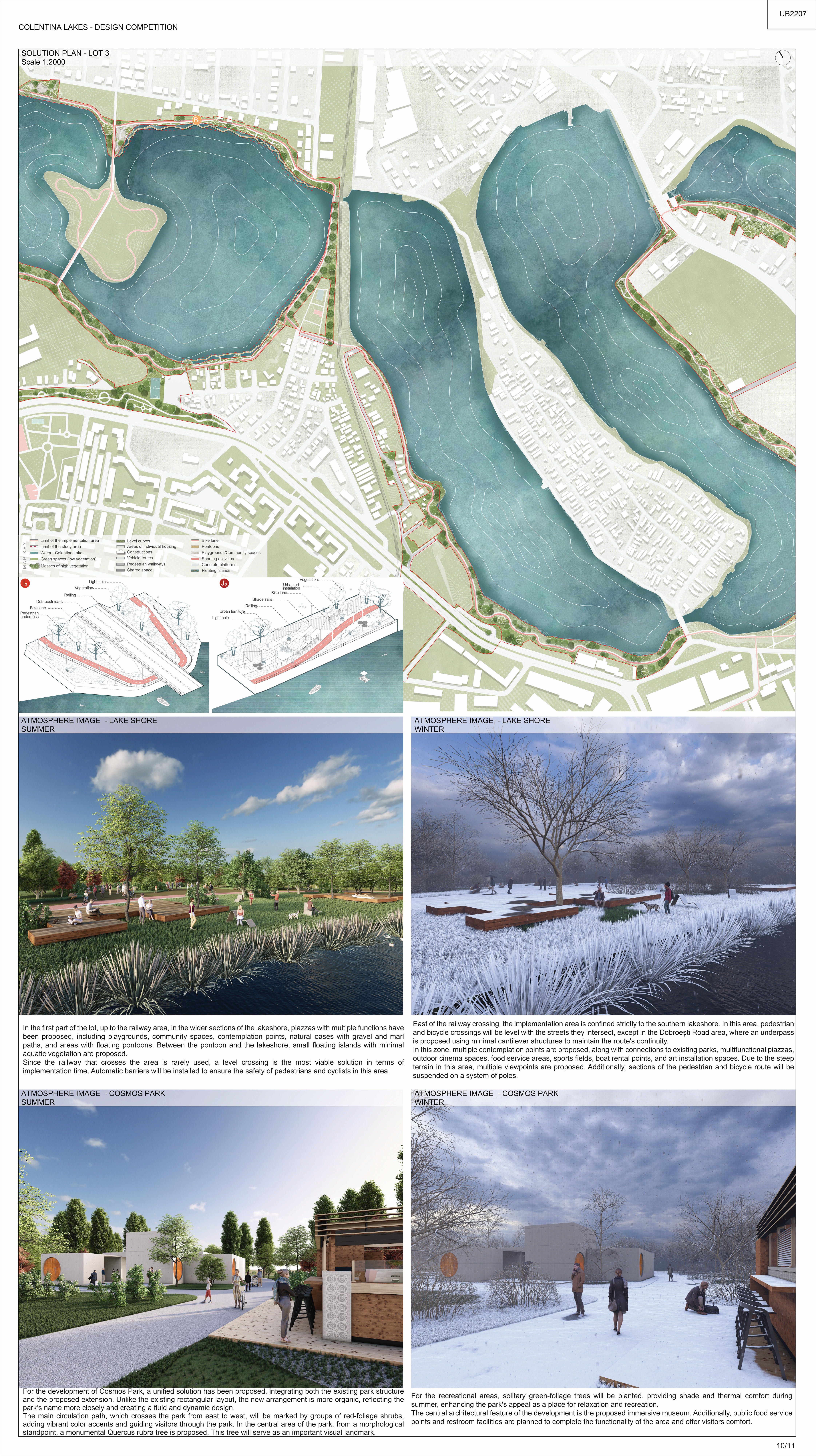
Text 1: In the first part of the lot, up to the railway area, in the wider sections of the lakeshore, piazzas with multiple functions have been proposed, including playgrounds, community spaces, contemplation points, natural oases with gravel and marl paths, and areas with floating pontoons. Between the pontoon and the lakeshore, small floating islands with minimal aquatic vegetation are proposed.
Since the railway that crosses the area is rarely used, a level crossing is the most viable solution in terms of implementation time. Automatic barriers will be installed to ensure the safety of pedestrians and cyclists in this area.
East of the railway crossing, the implementation area is confined strictly to the southern lakeshore. In this area, pedestrian and bicycle crossings will be level with the streets they intersect, except in the Dobroești Road area, where an underpass is proposed using minimal cantilever structures to maintain the route’s continuity.
In this zone, multiple contemplation points are proposed, along with connections to existing parks, multifunctional piazzas, outdoor cinema spaces, food service areas, sports fields, boat rental points, and art installation spaces. Due to the steep terrain in this area, multiple viewpoints are proposed. Additionally, sections of the pedestrian and bicycle route will be suspended on a system of poles.
Text 2: For the development of Cosmos Park, a unified solution has been proposed, integrating both the existing park structure and the proposed extension. Unlike the existing rectangular layout, the new arrangement is more organic, reflecting the park’s name more closely and creating a fluid and dynamic design.
The main circulation path, which crosses the park from east to west, will be marked by groups of red-foliage shrubs, adding vibrant color accents and guiding visitors through the park. In the central area of the park, from a morphological standpoint, a monumental Quercus rubra tree is proposed. This tree will serve as an important visual landmark.
For the recreational areas, solitary green-foliage trees will be planted, providing shade and thermal comfort during summer, enhancing the park’s appeal as a place for relaxation and recreation.
The central architectural feature of the development is the proposed immersive museum. Additionally, public food service points and restroom facilities are planned to complete the functionality of the area and offer visitors comfort.
Sheet 11 (EN)
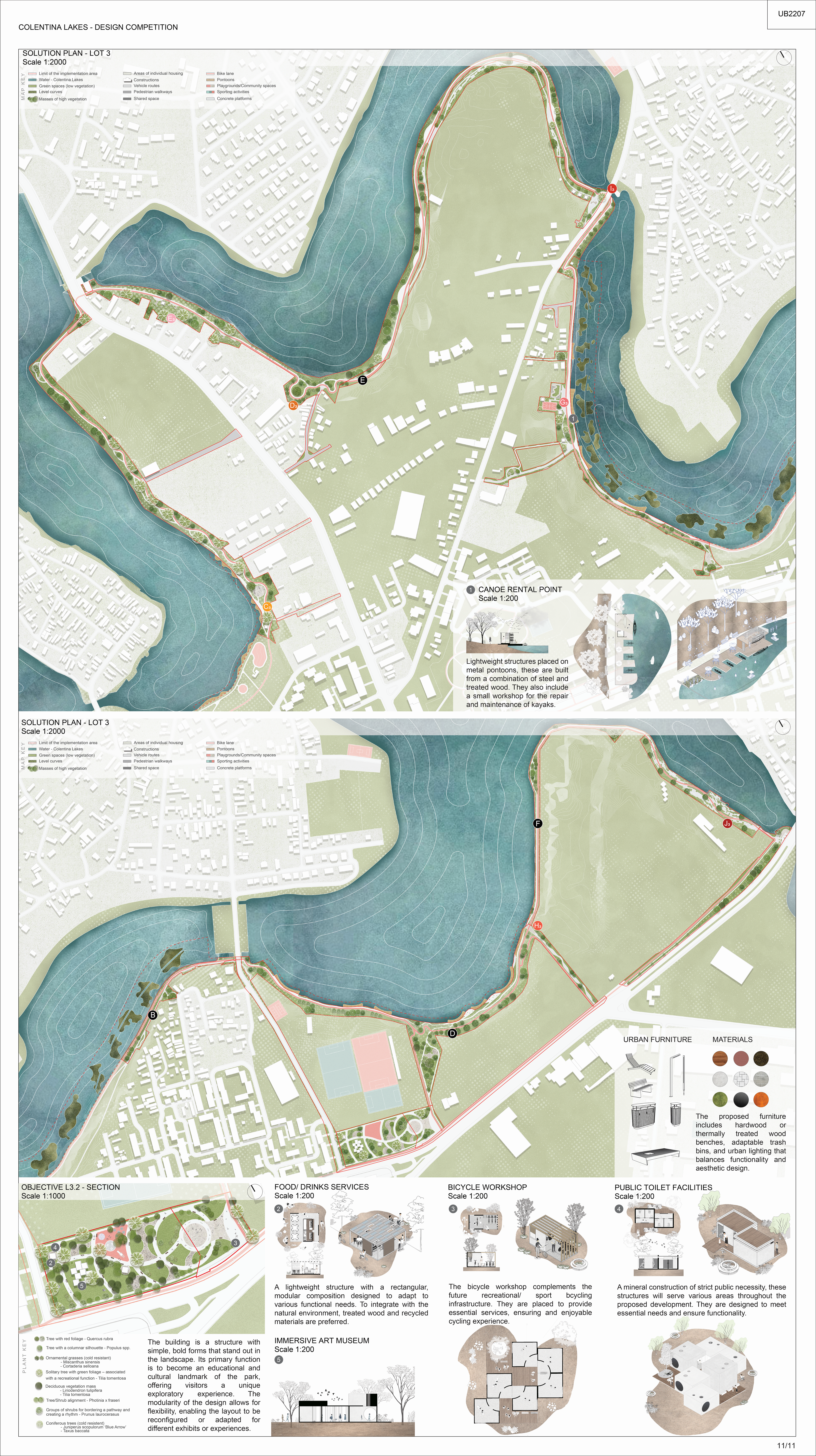
Text 1: The construction is a structure with simple, bold forms that stand out in the landscape. Its primary function is to become an educational and cultural landmark of the park, offering visitors a unique exploratory experience. The modularity of the design allows for flexibility, enabling the layout to be reconfigured or adapted for different exhibits or experiences.
Text 2: Lightweight structures placed on metal pontoons, these are built from a combination of steel and treated wood. They also include a small workshop for the repair and maintenance of kayaks.
Text 3: A lightweight structure with a rectangular, modular composition designed to adapt to various functional needs. To integrate with the natural environment, treated wood and recycled materials are preferred.
Text 4 The bicycle workshop complements the future recreational/ sport bcycling infrastructure. They are placed to provide essential services, ensuring and enjoyable cycling experience.
Text 5: A mineral construction of strict public necessity, these structures will serve various areas throughout the proposed development. They are designed to meet essential needs and ensure functionality.
Text 6: The proposed furniture includes hardwood or thermally treated wood benches, adaptable trash bins and urban lighting that balances functionality and aesthetics design.