


111 – DN2825 – STARH – ARHITECTURĂ, CONSTRUCȚII, DESIGN SRL
Autori principali: Florian Stanciu, Roberta Iulia Frumușelu, Eduard Dumitru Untaru, Cosmin Gălățianu, Octavian Bîrsan, David Sebastian Mihai
Coautori: Maria-Iulia Stanciu, Alexandru Cristian Beșliu, Nela Andrieș, Adelina Marin, Andrei Dobriță, Tudor Stănilă
Colaboratori Specialități: peis. Alexandru Gheorghe
DN3C Park
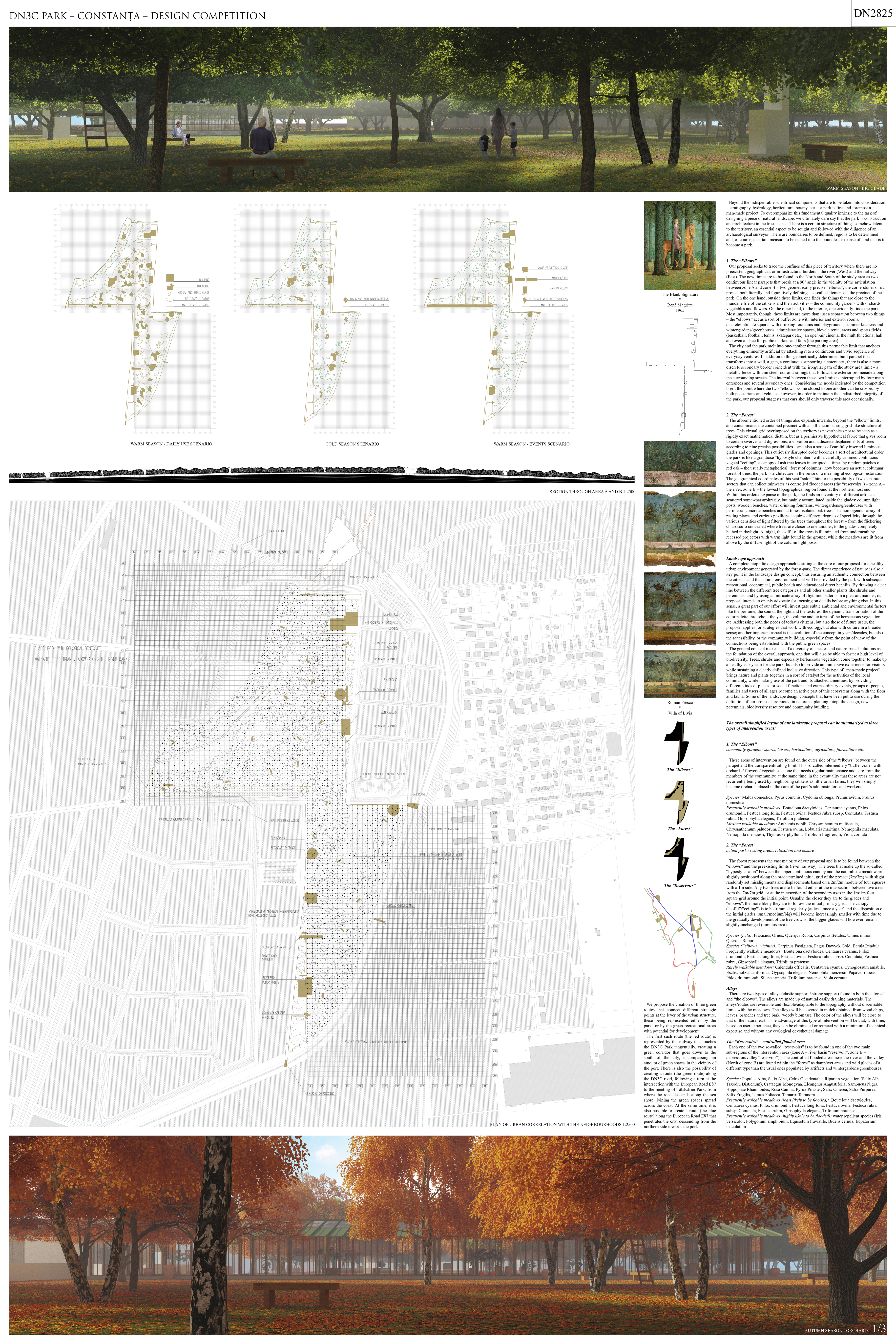
Beyond the indispensable scientifical components that are to be taken into consideration – stratigraphy, hydrology, horticulture, botany, etc. – a park is first and foremost a man-made project. To overemphasize this fundamental quality intrinsic to the task of designing a piece of natural landscape, we ultimately dare say that the park is construction and architecture in the truest sense. There is a certain structure of things somehow latent to the territory, an essential aspect to be sought and followed with the diligence of an archaeological surveyor. There are boundaries to be defined, regions to be determined and, of course, a certain measure to be etched into the boundless expanse of land that is to become a park.
The “Elbows”
Our proposal seeks to trace the confines of this piece of territory where there are no preexistent geographical, or infrastructural borders – the river (West) and the railway (East). The new limits are to be found to the North and South of the study area as two continuous linear parapets that break at a 90° angle in the vicinity of the articulation between zone A and zone B – two geometrically precise “elbows”, the cornerstones of our project both literally and figuratively defining a so-called “temenos”, the precinct of the park. On the one hand, outside these limits, one finds the things that are close to the mundane life of the citizens and their activities – the community gardens with orchards, vegetables and flowers. On the other hand, to the interior, one evidently finds the park. Most importantly, though, these limits are more than just a separation between two things – the “elbows” act as a sort of buffer zone with interior and exterior rooms, discrete/intimate squares with drinking fountains and playgrounds, summer kitchens and wintergardens/greenhouses, administrative spaces, bicycle rental areas and sports fields (basketball, football, tennis, skatepark etc.), an open-air cinema, the multifunctional hall and even a place for public markets and fairs (the parking area).
The city and the park melt into one-another through this permeable limit that anchors everything eminently artificial by attaching it to a continuous and vivid sequence of everyday ventures. In addition to this geometrically determined built parapet that transforms into a wall, a gate, a continuous supporting element etc., there is also a more discrete secondary border coincident with the irregular path of the study area limit – a metallic fence with thin steel rods and railings that follows the exterior promenade along the surrounding streets. The interval between these two limits is interrupted by four main entrances and several secondary ones. Considering the needs indicated by the competition brief, the point where the two “elbows” come closest to one another can be crossed by both pedestrians and vehicles, however, in order to maintain the undisturbed integrity of the park, our proposal suggests that cars should only traverse this area occasionally.
The “Forest”
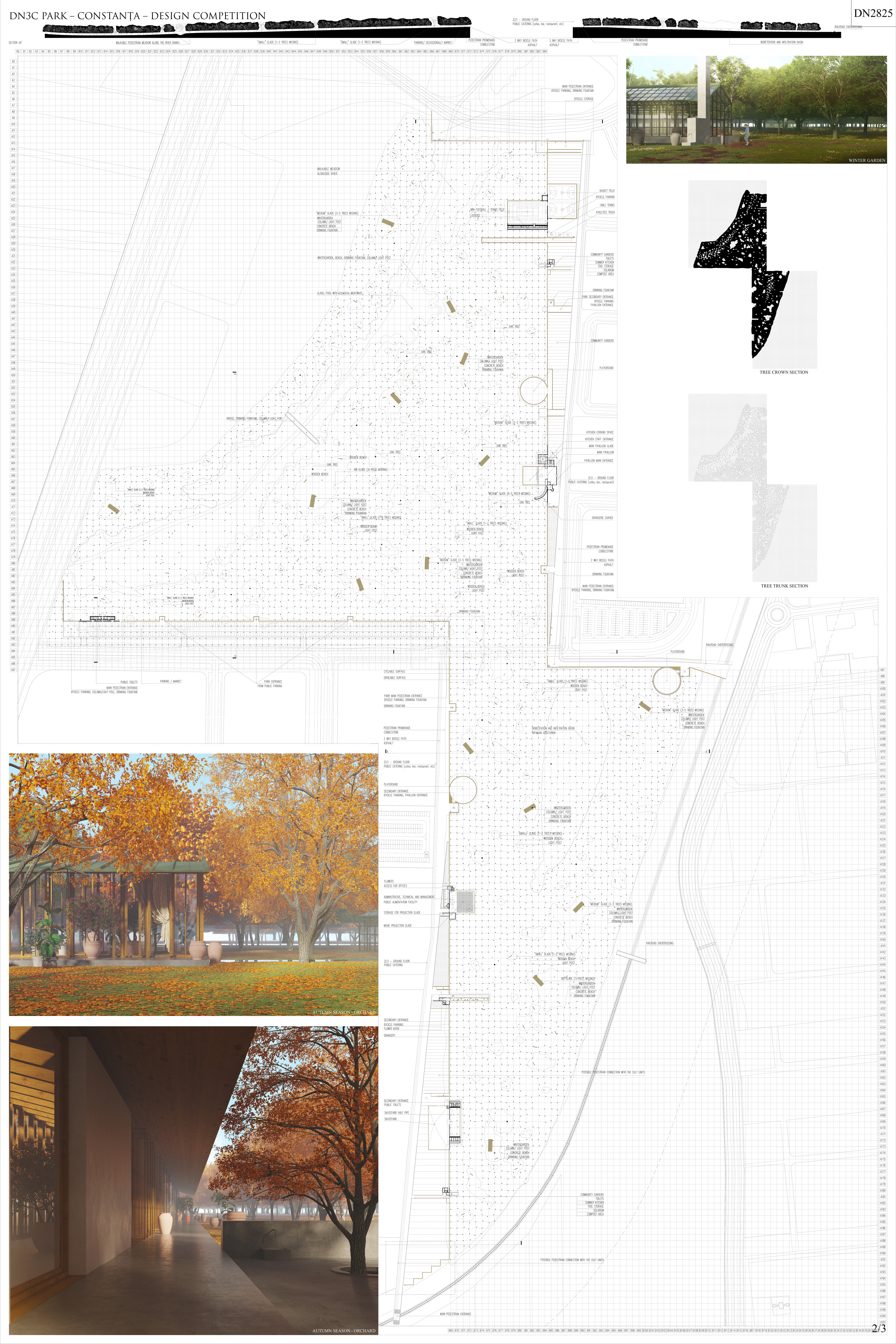
The aforementioned order of things also expands inwards, beyond the “elbow” limits, and contaminates the contained precinct with an all-encompassing grid-like structure of trees. This virtual grid overimposed on the territory is nevertheless not to be seen as a rigidly exact mathematical dictum, but as a permissive hypothetical fabric that gives room to certain swerves and digressions, a vibration and a discrete displacements of trees – according to nine precise possibilities – and also a series of carefully inserted luminous glades and openings. This curiously disrupted order becomes a sort of architectural order, the park is like a grandiose “hypostyle chamber” with a carefully trimmed continuous vegetal “ceiling”, a canopy of ash tree leaves interrupted at times by random patches of red oak – the usually metaphorical “forest of columns” now becomes an actual columnar forest of trees, the park is architecture in the sense of a meaningful ecological restoration. The geographical coordinates of this vast “salon” hint to the possibility of two separate sectors that can collect rainwater as controlled flooded areas (the “reservoirs”) – zone A – the river, zone B – the lowest topographical region found at the northernmost end.
Within this ordered expanse of the park, one finds an inventory of different artifacts scattered somewhat arbitrarily, but mainly accumulated inside the glades: column light posts, wooden benches, water drinking fountains, wintergardens/greenhouses with perimetral concrete benches and, at times, isolated oak trees. The homogenous array of resting places and curious pavilions acquires different degrees of specificity through the various densities of light filtered by the trees throughout the forest – from the flickering chiaroscuro concealed where trees are closer to one-another, to the glades completely bathed in daylight. At night, the soffit of the trees is illuminated from underneath by recessed projectors with warm light found in the ground, while the meadows are lit from above by the diffuse light of the column light posts.

Landscape approach
A complete biophilic design approach is sitting at the core of our proposal for a healthy urban environment generated by the forest-park. The direct experience of nature is also a key point in the landscape design concept, thus ensuring an authentic connection between the citizens and the natural environment that will be provided by the park with subsequent recreational, economical, public health and educational direct benefits. By drawing a clear line between the different tree categories and all other smaller plants like shrubs and perennials, and by using an intricate array of rhythmic patterns in a pleasant manner, our proposal intends to openly advocate for focusing on details before anything else. In this sense, a great part of our effort will investigate subtle ambiental and environmental factors like the perfume, the sound, the light and the textures, the dynamic transformation of the color palette throughout the year, the volume and textures of the herbaceous vegetation etc. Addressing both the needs of today’s citizens, but also those of future users, the proposal applies for strategies that work with ecology, but also with culture in a broader sense; another important aspect is the evolution of the concept in years/decades, but also the accessibility, or the community building, especially from the point of view of the connections being established with the public green spaces.
The general concept makes use of a diversity of species and nature-based solutions as the foundation of the overall approach, one that will also be able to foster a high level of biodiversity. Trees, shrubs and especially herbaceous vegetation come together to make up a healthy ecosystem for the park, but also to provide an immersive experience for visitors while sustaining a clearly defined inclusive direction. This type of “man-made project” brings nature and plants together in a sort of catalyst for the activities of the local community, while making use of the park and its attached amenities; by providing different kinds of places for social functions and extra-ordinary events, groups of people, families and users of all ages become an active part of this ecosystem along with the flora and fauna. Some of the landscape design concepts that have been put to use during the definition of our proposal are rooted in naturalist planting, biophilic design, new perennials, biodiversity resource and community building.
The overall simplified layout of our landscape proposal can be summarized to three types of intervention areas:
The “Elbows” – community gardens / sports, leisure, horticulture, agriculture, floriculture etc.
These areas of intervention are found on the outer side of the “elbows” between the parapet and the transparent/railing limit. This so-called intermediary “buffer zone” with orchards / flowers / vegetables is one that needs regular maintenance and care from the members of the community; at the same time, in the eventuality that these areas are not recurrently being used by neighboring citizens as little urban farms, they will simply become orchards placed in the care of the park’s administrators and workers.
Species: Malus domestica, Pyrus comunis, Cydonia oblonga, Prunus avium, Prunus domestica
Frequently walkable meadows: Bouteloua dactyloides, Centaurea cyanus, Phlox drumondii, Festuca longifolia, Festuca ovina, Festuca rubra subsp. Comutata, Festuca rubra, Gipsophylla elegans, Trifolium pratense
Medium walkable meadows: Anthemis nobili, Chrysanthemum multicaule, Chrysanthemum paludosum, Festuca ovina, Lobularia maritima, Nemophila maculata, Nemophila menziesii, Thymus serphyllum, Trifolium fragiferum, Viola cornuta
The “Forest” – actual park / resting areas, relaxation and leisure
The forest represents the vast majority of our proposal and is to be found between the “elbows” and the preexisting limits (river, railway). The trees that make up the so-called “hypostyle salon” between the upper continuous canopy and the naturalistic meadow are slightly positioned along the predetermined initial grid of the project (7m/7m) with slight randomly set misalignments and displacements based on a 2m/2m module of four squares with a 1m side. Any two trees are to be found either at the intersection between two axes from the 7m/7m grid, or at the intersection of the secondary axes in the 1m/1m four square grid around the initial point. Usually, the closer they are to the glades and “elbows”, the more likely they are to follow the initial primary grid. The canopy (“soffit”/”ceiling”) is to be trimmed regularly (at least once a year) and the disposition of the initial glades (small/medium/big) will become increasingly smaller with time due to the gradually development of the tree crowns; the bigger glades will however remain slightly unchanged (tumulus area).
Species (field): Fraxisnus Ornus, Querqus Rubra, Carpinus Betulus, Ulmus minor, Querqus Robur
Species (“elbows” vicinity): Carpinus Fastigiata, Fagus Dawyck Gold, Betula Pendula
Frequently walkable meadows: Bouteloua dactyloides, Centaurea cyanus, Phlox drumondii, Festuca longifolia, Festuca ovina, Festuca rubra subsp. Comutata, Festuca rubra, Gipsophylla elegans, Trifolium pratense
Rarely walkable meadows: Calendula officalis, Centaurea cyanus, Cynoglossum amabile, Eschscholzia californica, Gypsophila elegans, Nemophila menziesii, Papaver rhoeas, Phlox drummondi, Silene armeria, Trifolium pratense, Viola cornuta
Alleys: There are two types of alleys (elastic support / strong support) found in both the “forest” and “the elbows”. The alleys are made up of natural easily draining materials. The alleys/routes are reversible and flexible/adaptable to the topography without discernable limits with the meadows. The alleys will be covered in mulch obtained from wood chips, leaves, branches and tree bark (woody biomass). The color of the alleys will be close to that of the natural earth. The advantage of this type of intervention will be that, with time, based on user experience, they can be eliminated or retraced with a minimum of technical expertise and without any ecological or esthetical damage.
The “Reservoirs” – controlled flooded area
Each one of the two so-called “reservoirs” is to be found in one of the two main sub-regions of the intervention area (zone A – river basin “reservoir”, zone B – depression/valley “reservoir”). The controlled flooded areas near the river and the valley (North of zone B) are found within the “forest” as damp/wet areas and wild glades of a different type than the usual ones populated by artifacts and wintergardens/greenhouses.
Species: Populus Alba, Salix Alba, Celtis Occidentalis, Riparian vegetation (Salix Alba, Taxodiu Distichum), Crataegus Monogyna, Eleangnus Angustifolia, Sambucus Nigra, Hippophae Rhamnoides, Rosa Canina, Pyrux Piraster, Salix Cinerea, Salix Purpurea, Salix Fragilis, Ulmus Foliacea, Tamarix Tetrandra
Frequently walkable meadows (least likely to be flooded): Bouteloua dactyloides, Centaurea cyanus, Phlox drumondii, Festuca longifolia, Festuca ovina, Festuca rubra subsp. Comutata, Festuca rubra, Gipsophylla elegans, Trifolium pratense
Frequently walkable meadows (highly likely to be flooded): water repellent species (Iris versicolor, Polygonum amphibium, Equisetum fluviatile, Bidens cernua, Eupatorium maculatum
We propose the creation of three green routes that connect different strategic points at the lever of the urban structure, these being represented either by the parks or by the green recreational areas with potential for development.
The first such route (the red route) is represented by the railway that touches the DN3C Park tangentially, creating a green corridor that goes down to the south of the city, encompassing an amount of green spaces in the vicinity of the port. There is also the possibility of creating a route (the green route) along the DN3C road, following a turn at the intersection with the European Road E87 to the meeting of Tăbăcăriei Park, from where the road descends along the sea shore, joining the green spaces spread across the coast. At the same time, it is also possible to create a route (the blue route) along the European Road E87 that penetrates the city, descending from the northern side towards the port.