


100 – PE2030 – Metapolis Architects SPRL & Studio de Peisaj Ana Horhat SRL & Atelier Mass SRL
Autori principali: Metapolis Architects, Studio de Peisaj Ana Horhat, Atelier Mass
ASOCIERE
Metapolis Architects SPRL, Asociat 33,33%
Studio de Peisaj Ana Horhat SRL, Asociat 33,33%
Atelier Mass SRL, Asociat 33,33%
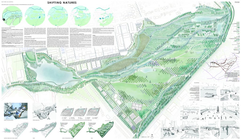
SHIFTING CONFLUENCES
I. TRACING LANDSCAPE DYNAMICS
The site finds itself at the intersection of a diversity of geo-morphological systems:
- Geologically, it is at the edge of the Western salt diapir alignment, where it meets the Badenian sedimentary strata, topped by the alluvial deposits. This creates the conditions for places like the Someseni Baths, but also has an impact on the wetland areas in the park, as they are all interconnected by the “ROSO10” aquifer. In different spots throughout the site there are slightly different values of salinity, which in turn encourages slightly different ecosystems to evolve.
- Topographically, it is at the confluence of the Becas creek and the Somes river plain. The ancient side branch of the river Somes shaped the higher terrace and left behind some steeper edges, before encountering resistance on the natural dam formed by the harder strata next to the Someseni Baths. It is also here that the Becas creek reaches the Somes plain, creating a confluence wetland behind the natural dam.
These ground conditions set the stage for the emergence of a thriving, but also very dynamic wetland. A mapping of its traces over the past centuries reveals its shifting waters and the shifting ecosystems that go with them.
In the last centuries however, as the city expanded on the surrounding higher grounds, the leftover marshes and lakes started to receive complementary (sub)urban functions. In the first half of the 20th century it was already an acknowledged green-blue leisure destination, known as the “lakes of the city”. At the same time, other functions such as garbage disposal were putting a strain on its ecology. The development of the tree nursery on the other hand, with its characteristic exploitation, rationalized the tip of the higher plateau and introduced yet another dynamic layer, this time man-driven. Last but not least, the place attracted further development around it in the last decades, reducing the open space significantly.
II. SHIFTING NATURES
The shifting ecosystems on site must sit at the core of its future protection and regeneration.
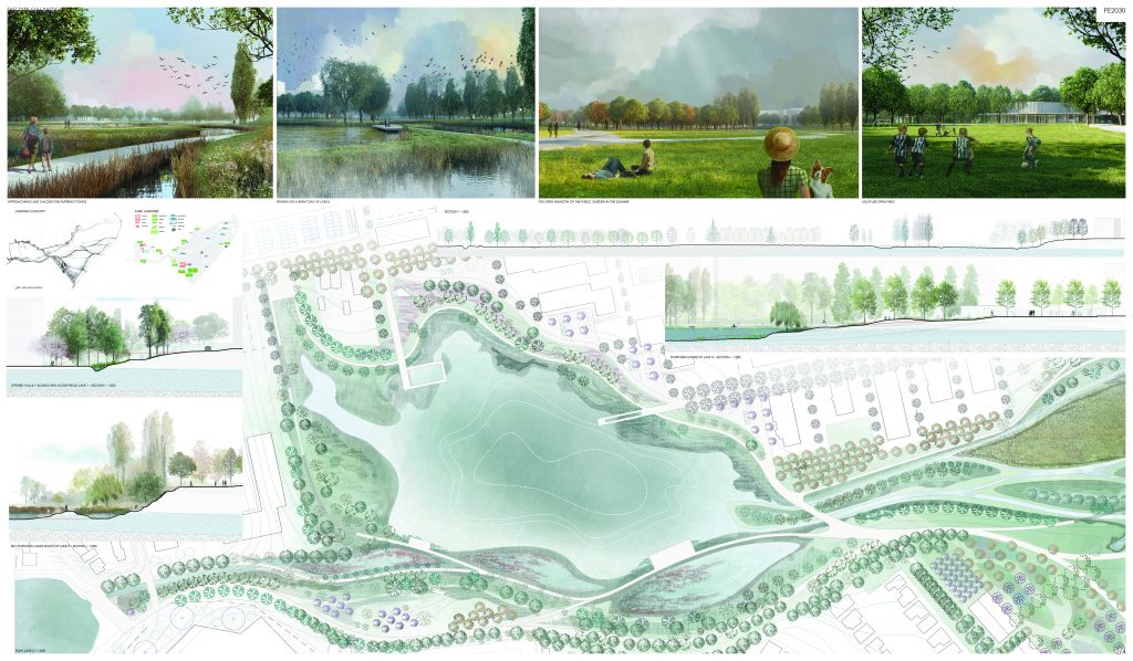
Unveiled landscape, expanded ecology
The starting point of the project is the mapping over time of the various habitats forming this fragile ecosystem (marsh, swamp, upland, wet meadow, dry meadows, riparian forest corridors along the river, tree clumps and tiny forests, all with their fauna), in order to create the best conditions for each of them, but also to reveal the real nature of each habitat to the public in a non-invasive manner.
In the next step, the goal is to allow nature to further take over the site. This is done by enriching the biodiversity of certain habitats within their boundaries, such as the local amplification of the water edge, or by creating new areas of expansion into large buffer zones between the biotope reserve and the most active parts of the park. Similar ecologies can develop here as in the protected areas, but with a slightly more permissive human presence. Finally, the nature reclamation can be realised through the renaturation of degraded landscapes, such as the re-expansion of the Becas valley.
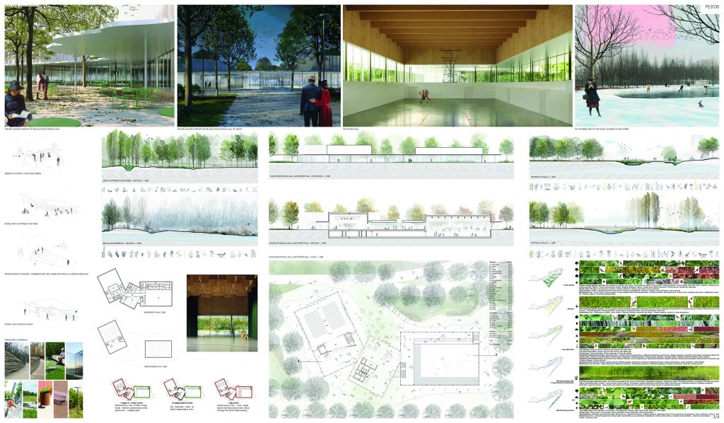
A park for both an intimate connection to nature and for human interaction
A series of thematic circuits will raise awareness and allow for educational-recreational experiences for all types of public, understanding the local habitats, while placing them in the bigger contexts on different scales. The park thus becomes also a window into the bigger dynamics of the city, its surrounding landscapes, the region. Furthermore, the diversity of spaces in the park, big and small, allow for a wide spectrum of experiences from the individual to the shared and communal.
While the protected areas are excluded from the circuits of the park, by doubling these zones with a similar natural buffer, the visitors can experience the richness of the wetland without having to reach the protected secluded area.
Last but not least, the park becomes a green-blue infrastructure for the inhabitants, a backbone for the soft mobility connections of the surrounding neighbourhoods, following the future inter-connected planted corridors with no car-traffic and hosting the collector system of harvested rainwater. The park can thus become the spine for the future green transition of these areas.
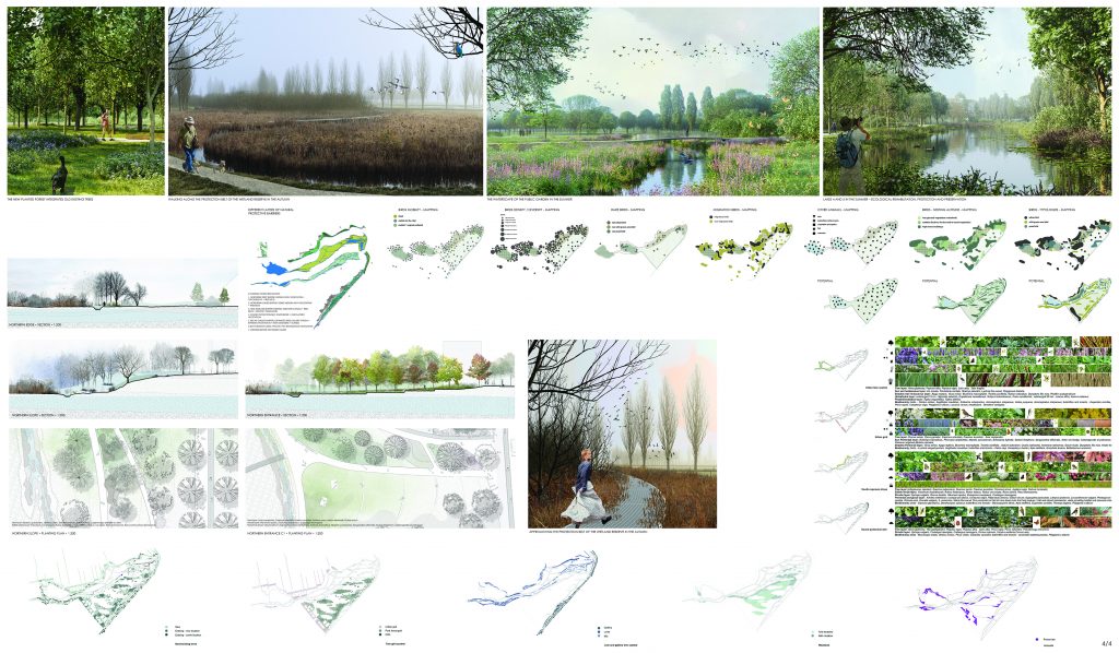
An ever-evolving landscape in time
Continuous change and transformation of both organic and mineral worlds is the defining dynamic of a landscape. During these continuous transformation processes there are moments when the ecosystem is rich and diverse but also moments of decay characterized by a decreasing variety of species. These moments of low and high variety of species seem to be regulated by the presence of water and the absence of human intervention.
Our design proposes different island environments linked in one park as a unifying landscape. These islands are bordered by water which regulates the perfect life conditions for flora and fauna and protects them from intrusion.
Water links the islands offering a variety of habitats from marshland to dry meadows and river landscape.
This initial configuration of islands and situations proposed by our design is not static, some islands will be occasionally submerged while others will dry out offering a surprising new evolution of the landscape and inviting new species during the coming years.
The proposed water network works as communicating vessels between the different habitats. Regulated by water these habitats will balance themselves offering resilience and guaranteeing a good dynamic for the whole landscape ecosystem.
In order to prevent the visitors from disturbing the wildlife we provide hidden passages soundproofed by dense structures of vegetation or light structures like pavilions.
Elevated paths are protecting the regeneration of flora and fauna.
The wet ditches and water bodies are strong ecological corridors.
III. PHASING
As a general rule, the implementation process will go from up- to downstream and from the surrounding urban fringes towards the biotope. In the initial phases, the piping needed for the recondition will be installed, increasing phytoremediation treatment upstream from wetland, improving thus the site’s native wetland areas. In subsequent phases the infrastructure needed to divert treated effluent into downstream ponds will be installed, the watershore will be renovated to facilitate public access and environmental education, the native wetland and the riparian habitat will start to be restored. This will be done over time, with initial tests on a smaller scale and subsequent iterative processes of tuning and adaptation, all while conducting water quality monitoring. Several workshops will be conducted to educate the public and community leaders on the importance of wetlands and to provide information about the project.